Giza
| Giza الجيزة | |||
|---|---|---|---|
| City | |||
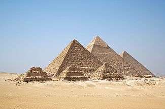
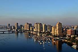 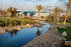   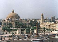 Clockwise from top: Giza panorama, Pyramids of Giza, Cairo University, Four Seasons Giza, Smart Village | |||
| |||
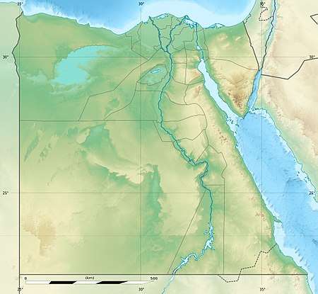 Giza Location of Giza within Egypt | |||
| Coordinates: 30°01′N 31°13′E / 30.017°N 31.217°ECoordinates: 30°01′N 31°13′E / 30.017°N 31.217°E | |||
| Country |
| ||
| Governorate | Giza | ||
| Founded | 642 AD | ||
| Area | |||
| • Total | 1,579.75 km2 (609.94 sq mi) | ||
| Elevation | 19 m (62 ft) | ||
| Population (2012) | |||
| • Total | 3,628,062 | ||
| • Density | 2,300/km2 (5,900/sq mi) | ||
| Time zone | UTC+2 (EET) | ||
| Area code(s) | (+20) 2 | ||
| Website | www.giza.gov.eg | ||


Giza (/ˈɡiːzə/; sometimes spelled Gizah or Jizah; Arabic: الجيزة al-Jīzah, Egyptian Arabic pronunciation: [el ˈgiːze]; Coptic: ϯⲡⲉⲣⲥⲏⲥ, ⲅⲓⲍⲁ Tiperses, Giza) is the third-largest city in Egypt and the capital of the Giza Governorate. It is located on the west bank of the Nile, 4.9 km (3 mi) southwest of central Cairo. Along with Cairo Governorate, Shubra El Kheima, Helwan, 6th October City and Obour, the five form Greater Cairo metropolis.
Giza lies less than 20 km (12.43 mi) north of "Mn Nefer" (Memphis, in Greek), which means "the beautiful wall" in the ancient Egyptian language, and which was the capital city of the first unified Egyptian state since the days of Pharaoh Narmer.
Giza is most famous as the location of the Giza Plateau: the site of some of the most impressive ancient monuments in the world, including a complex of ancient Egyptian royal mortuary and sacred structures, including the Great Sphinx, the Great Pyramid of Giza, and a number of other large pyramids and temples. Giza has always been a focal point in Egypt's history due to its location close to Memphis, the ancient Pharaonic capital of the Old Kingdom. Its St. George cathedral is the episcopal see of the Coptic Catholic Eparchy of Giza.
Geography
The "city" of Giza is the capital of the Giza Governorate, and is located near the northeast border of this governorate. The city's population was 2,681,863 in the 2006 national census, while the governorate had 6,272,571 at the same census. Technically, Giza may not be an incorporated municipal unit at all (and therefore not a city) at all, in a typical Egyptian fashion, there are two districts within the Governorate with the same name: a kism/qasm and associated markiz. Some 9 urban kisms collectively of Giza Governorate form a contiguous area of 98.4km2 directly opposite side of the Nile from Cairo, and recorded a population of 4,146,340 in 2017 census count[1], not including the Al-Ḥawāmidiyah kism separated by Giza markiz. Its unclear that the 9 urban kisms represent a single entity; the structure may be similar to that of 23 wards of Tokyo in that all local units are simply subordinate to the Governorate without any intermediate municipal structure.
Giza's most famous land form and archaeological site, the Giza Plateau, holds some major monuments of Egyptian history, and is home to the Great Sphinx. Once thriving with the Nile that flowed right into the Giza Plateau, the pyramids of Giza were built overlooking the ancient Egyptian capital city of Memphis, across the river from modern day Cairo. The Giza Plateau is also home to Egyptian monuments such as the tomb of Pharaoh Djet of the First Dynasty, as well as that of Pharaoh Ninetjer of the Second Dynasty. The Great Pyramid of Giza at one time was advocated (1884) as the location for the Prime Meridian, a reference point used for determining a base longitude.[2]
Climate
Giza experiences a hot desert climate like arid climate (Köppen: BWh). Its climate is similar to Cairo, owing to its proximity. Wind storms can be frequent across Egypt in spring, bringing Saharan dust into the city during the months of March and April. High temperatures in winter range from 16 to 20 °C (61 to 68 °F), while nighttime lows drop to below 7 °C (45 °F). In summer, the highs are 40 °C (104 °F), and the lows can drop to about 20 °C (68 °F). Rain is infrequent in Giza; snow and freezing temperatures are extremely rare.
Up to August 2013, the highest recorded temperature was 46 °C (115 °F) on 13 June 1965, while the lowest recorded temperature was 2 °C (36 °F) on 8 January 1966.[3]
| Climate data for Giza | |||||||||||||
|---|---|---|---|---|---|---|---|---|---|---|---|---|---|
| Month | Jan | Feb | Mar | Apr | May | Jun | Jul | Aug | Sep | Oct | Nov | Dec | Year |
| Record high °C (°F) | 28 (82) |
30 (86) |
36 (97) |
41 (106) |
43 (109) |
46 (115) |
41 (106) |
43 (109) |
39 (102) |
40 (104) |
36 (97) |
30 (86) |
46 (115) |
| Average high °C (°F) | 19.3 (66.7) |
20.9 (69.6) |
24.2 (75.6) |
28.4 (83.1) |
32.0 (89.6) |
34.9 (94.8) |
34.5 (94.1) |
34.4 (93.9) |
32.4 (90.3) |
30.2 (86.4) |
25.4 (77.7) |
21.1 (70) |
28.1 (82.6) |
| Daily mean °C (°F) | 13.0 (55.4) |
14.0 (57.2) |
17.2 (63) |
20.5 (68.9) |
24.0 (75.2) |
27.1 (80.8) |
27.5 (81.5) |
27.5 (81.5) |
25.6 (78.1) |
23.5 (74.3) |
19.2 (66.6) |
15.0 (59) |
21.2 (70.1) |
| Average low °C (°F) | 6.8 (44.2) |
7.2 (45) |
10.3 (50.5) |
12.7 (54.9) |
16.1 (61) |
19.3 (66.7) |
20.6 (69.1) |
20.7 (69.3) |
18.9 (66) |
16.8 (62.2) |
13.0 (55.4) |
8.9 (48) |
14.3 (57.7) |
| Record low °C (°F) | 2 (36) |
4 (39) |
5 (41) |
8 (46) |
11 (52) |
16 (61) |
17 (63) |
17 (63) |
16 (61) |
11 (52) |
4 (39) |
4 (39) |
2 (36) |
| Average precipitation mm (inches) | 4 (0.16) |
3 (0.12) |
2 (0.08) |
1 (0.04) |
0 (0) |
0 (0) |
0 (0) |
0 (0) |
0 (0) |
0 (0) |
3 (0.12) |
4 (0.16) |
17 (0.68) |
| Source #1: Climate-Data.org[4] | |||||||||||||
| Source #2: Voodoo Skies[3] for record temperatures | |||||||||||||
Districts and neighbourhoods
- Dokki District: 93,660 93,025
- Agouza District: 174,460 162,851
- Giza District: 180,568 246,325, Kism Al Jizah 238,567 248,897
- Bulaq ad Dakrur: 453,884 564,791
- Imbabah: 287,357 389,049, Kism Imbabah 523,265 597,160
- Haram District: 200,076 295,704
- Omrania
- Monib
- Kafr Tuhurmus
The centre of the city is Giza Square.
- Faisal district
History
Ancient era
The area in what is now Giza served as the necropolis of several pharaohs who ruled ancient Egypt, during the 2nd millennium BC. Three of these tombs, in the form of giant pyramids, are what is now the famed Three Pyramids of Giza.
Classical to medieval era
As ancient Egypt passed under several conquests under the Persians, Greeks, Romans and Byzantines, so did the area in what is now Giza. A Byzantine village named Teresa, located south of Giza, existed before the Muslim conquest of the region.[5][6]
Native Egyptians called the area Tiperses (also Tiperses Nbabylon (which most likely refers to Babylon Fortress but may as well refer to Babylon in Mesopotamia) Tipersoi, Perso), which may correspond to Persians (as the name may be literally translated as "Persians of/from Babylon"), but the exact origin of this name remains unclear.[7][8]
As Muslims of the fledging Islamic caliphate went on with their conquest of Egypt from the Byzantine Empire beginning in 639 AD, three years after their victory at the battle of Yarmouk in 636 AD, they conquered all of the land by the time they have captured the city of Alexandria in 641 AD. A year later in 642 AD (year 21 in Islamic calendar), they founded the city of Giza. Its name, al-Jizzah in Arabic, means "the valley" or "the plateau", pertaining to the area's topography.
Infrastructure
Giza has seen many changes over time. Changes in infrastructure during the different occupations of Egypt by various rulers, including the British in the 18th and early 20th century, focused on the construction of roads, streets, and buildings in the area. Giza is a thriving centre of Egyptian culture and is quite heavily populated, with many facilities and buildings in the current area. Giza saw much attention in particular to its vast amount of ancient Egyptian monuments found on the Giza Plateau, and has astonished thousands of visitors and tourists over the years. Giza's infrastructure saw much attention from both the British government prior to the 1952 coup d'état, as well as the current Egyptian government due to the city's importance in tourism.
The city hosts the first zoo on the entire African continent and one of the oldest in the Mediterranean region, the Giza Zoo. In addition, there are several parks, the most famous among them is Orman Park, which means "Forest Park" in the Turkish language.
Health
Giza has advanced level of medical care just like its elder twin Cairo.
A list of famous hospitals in Giza:
- Agooza in Agouza district.
- Al Salam in Mohandessin neighbourhood.
- Badran in Dokki district.
- El Safa.
- Haram Hospital in Haram.
- El Shoruk Hospital.
- Cairo Medical Lab.
- El Giza hospital in Haram
- Tabarak children Hospital in Haram
- Nour El-oYoun Hospital in Haram
In addition to hospitals there are numerous medical facilities, private clinics, medical check laboratories etc.
Transportation
Transportation in Giza comprises an extensive road network, rail system, subway system, and maritime services. Road transport is facilitated by personal vehicles, taxi cabs, privately owned public buses and microbuses.
Giza shares with Cairo a subway system, officially called the "Metro (مترو)", a fast and efficient way of getting around. An extensive road network connects Giza with 6th of October City, Cairo and other cities. There are flyovers and bridges such as the 15th. Giza traffic is known to be overwhelming and overcrowded.
Economy
Industries here include movies, chemicals, machinery and cigarettes. In addition, Giza has many luxury apartment buildings along the Nile, making it a popular place to live.
International access
Access to the city of Giza, which has its own governorate adjacent to the Governorate of Cairo, is dependent on the Cairo International Airport. Another local airport is found in Giza, called the Imbaba Airport, but recently the Egyptian government has decided to shut down the area and turn it into a cultural or an athletic area.
Sphinx International Airport is scheduled to open in 2018.
Education
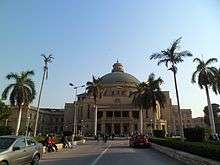
Giza's learning institutions include Cairo University, which was moved to Giza in 1924. The city is a hub of education and educational services not only for Egypt but also for the entire Mediterranean Region. Giza has numerous schools, kindergartens, and institutes of higher learning.
The Cairo Japanese School, a Japanese international school, is in Giza.[11] The Deutsche Evangelische Oberschule, a German international school, is located in Dokki in Giza.[12] Previously the Pakistan International School of Cairo had its campus in Giza.[13]
Sports
The city hosts the second most successful club in Egypt and Africa, El Zamalek, which is located in the Meet Okba neighbourhood near the Mohandesin neighbourhood. Beside El Zamalek there are other clubs like El Tersana and Seid Shooting Club which is one of the elite clubs in Egypt
Twin towns and sister cities


Memphis, Tennessee
See also
References
- ↑ http://citypopulation.de/php/egypt-admin.php
- ↑ "The Canary Islands and the Question of the Prime Meridian: The Search for Precision in the Measurement of the Earth", Wilcomb E. Washburn. link Archived 29 May 2007 at the Wayback Machine.
- 1 2 "El-Giza, Egypt". Voodoo Skies. Archived from the original on 29 October 2013. Retrieved 16 August 2013.
- ↑ "Climate: Giza – Climate graph, Temperature graph, Climate table". Climate-Data.org. Retrieved 16 August 2013.
- ↑ موسوعة " القاموس الجغرافى للبلاد المصرية " – محمد رمزى بك (قسم ثانى ج3 – ص4): مركز وثائق وتاريخ مصر المعاصر الهيئة المصرية العامةللكتاب ط 1994
- ↑ جغرافية مصر في العصر القبطى – الفرنسى أميلينو : الهيئة المصرية العامة للكتاب2013 ترجمة ميخائيل مكسى إسكندر – استدراكات العلامة محمد رمزى على الكتاب في الجزء الثالث من ص 274: نشر المعهد العلمى الفرنسى
- ↑ Amélineau, Emile (1893). La géographie de l’Egypte à l’époque copte. Paris: Imprimerie nationale. p. 190.
- ↑ "Trismegistos". www.trismegistos.org. Retrieved 2017-11-22.
- ↑ "Ya Om El Donia. Your Uber Has Just Arrived, Cairo! - Uber Blog". Uber.com. 20 November 2014. Retrieved 16 October 2017.
- ↑ "Ride or Drive with Careem in Cairo, Egypt - Careem". Careem.com. Retrieved 16 October 2017.
- ↑ Home (Archive). Cairo Japanese School. Retrieved on 2 January 2014. "NAZLET EL BATRAN EL AHRAM GIZA, A.R.EGYPT"
- ↑ "Kontakt." Deutsche Evangelische Oberschule. Retrieved on 18 January 2015. "6, El Dokki St. Dokki / Giza"
- ↑ "Contact Us." Pakistan International School Cairo. Retrieved on 21 April 2015. "12 Midan Tehran, Dokki, Cairo."
Further reading
- Der Manuelian, Peter. 2017. Digital Giza: Visualizing the Pyramids. Cambridge, Massachusetts: Harvard University Press.
- Hawass, Zahi A. 2010. Wonders of the Pyramids: The Sound and Light of Giza. Cairo: Misr Company for Sound, Light, & Cinema.
- --. 2011. Newly-Discovered Statues From Giza, 1990-2009. Cairo: Ministry of State for Antiquities.
- Magli, G. 2016. "The Giza 'written' landscape and the double project of King Khufu." Time & Mind-the Journal of Archaeology Consciousness and Culture 9, no.1: 57–74.
- Khattab, Hind A. S., Nabil Younis, and Huda Zurayk. 1999. Women, Reproduction, and Health In Rural Egypt: The Giza Study. Cairo, Egypt: American University in Cairo Press.
- Kormysheva, Ė. E., Svetlana Malykh, and Sergey Vetokhov. 2010. Giza, Eastern Necropolis: Russian Archaeological Mission In Giza. Moscow: Institute of Oriental Studies, Russian Academy of Sciences.
- Lawton, Ian, and Chris Ogilvie-Herald. 2000. Giza: The Truth: the People, Politics and History Behind the World's Most Famous Archaeological Site. Rev. ed. London: Virgin.
- Lehner, Mark, and Zahi A. Hawass. 2017. Giza and the Pyramids: The Definitive History. Chicago: The University of Chicago Press.
External links
| Library resources about Giza |


| 1,000,000 and more | |
|---|---|
| 300,000–999,999 | |
| 100,000–299,999 | |
| <99,999 | |
Ancient Egypt topics | ||
|---|---|---|
| ||
|  | |
| ||