Madinaty
| Madinaty | |
|---|---|
| suburb | |
 | |
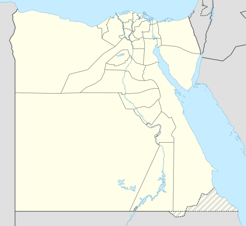 Madinaty Location in Egypt | |
| Coordinates: 30°05′30″N 31°37′50″E / 30.09167°N 31.63056°ECoordinates: 30°05′30″N 31°37′50″E / 30.09167°N 31.63056°E | |
| Country |
|
| Governorate | Cairo Governorate |
| Time zone | UTC+2 (EST) |
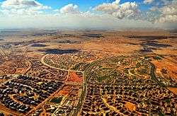
Madinaty (Arabic: مدينتى Egyptian Arabic pronunciation: [mæˈdenti], "My City") is a suburb, aimed at becoming a complete city, in northeast Cairo Governorate, Egypt. It is south of Shorouk and northeast of New Cairo.
Overview
The project is being constructed by Talaat Mostafa Group. The Master Planners are HHCP Design International, Inc. The landscape architects are the SWA group. Construction began on July 2006.
The contract by which the land was granted to the company was challenged in the Egyptian court. The Egyptians were angered that the land had been sold below value to Talaat Mostafa Group during Mubarak's rule.[1]
Madinaty is being built over an area of 3,200 hectares (8,000 acres), with a total budget of 60 Billion Egyptian pounds.[2]
In 2016, around 3900 residential units were sold in Madinaty by the Ministry of Housing.[3]
Madinaty has an advantage over El Rehab another project by Talaat Mostafa Group. that it has wider streets and the city is designed in terms of subcompounds where each subcompound has its facilities in terms of food store, mosque, clinic, parks for children to play and having a picnic.
Now in 2017 Madinaty has Arabsk Mall which contain lots of shops for selling utility items and a mechanic's shop and restaurants as well. Also a new restaurant compound called south park with over dozens of brand restaurants as supreme, pottery and chillies.
There’s also nurseries and schools as MILS and MIS school for all grades.
Madinaty has a large club with several pools, playgrounds, gym and clubhouse. It provides the residents to play sports and enjoy swimming all the year and do a lot of activities in it.
The environment is quite safe and it is very encouraging to take a walk in the parks or between the villas and buildings.
Infrastructure
Madinaty uses Advanced Metering Infrastructure for water and electricity distribution which is supplied by Manas Energy Management.
Climate
Köppen-Geiger climate classification system classifies its climate as hot desert (BWh)[4] as the rest of Egypt.
| Climate data for Madinaty | |||||||||||||
|---|---|---|---|---|---|---|---|---|---|---|---|---|---|
| Month | Jan | Feb | Mar | Apr | May | Jun | Jul | Aug | Sep | Oct | Nov | Dec | Year |
| Average high °C (°F) | 18 (64) |
19.7 (67.5) |
23.2 (73.8) |
27.9 (82.2) |
32.2 (90) |
34.4 (93.9) |
34.9 (94.8) |
34.5 (94.1) |
31.9 (89.4) |
29.7 (85.5) |
24.8 (76.6) |
20 (68) |
27.6 (81.6) |
| Daily mean °C (°F) | 12.8 (55) |
13.8 (56.8) |
16.6 (61.9) |
20.4 (68.7) |
24.2 (75.6) |
26.8 (80.2) |
27.8 (82) |
27.7 (81.9) |
25.5 (77.9) |
23.4 (74.1) |
19.2 (66.6) |
14.6 (58.3) |
21.1 (69.9) |
| Average low °C (°F) | 7.8 (46) |
8 (46) |
10.1 (50.2) |
12.9 (55.2) |
16.3 (61.3) |
19.3 (66.7) |
20.7 (69.3) |
21 (70) |
19.1 (66.4) |
17.1 (62.8) |
13.7 (56.7) |
9.3 (48.7) |
14.6 (58.3) |
| Average precipitation mm (inches) | 6 (0.24) |
4 (0.16) |
4 (0.16) |
2 (0.08) |
0 (0) |
0 (0) |
0 (0) |
0 (0) |
0 (0) |
1 (0.04) |
4 (0.16) |
5 (0.2) |
26 (1.04) |
| Source: Climate-Data.org (altitude: 230m)[4] | |||||||||||||
See also
References
- ↑ Rios, Lorena. "Egypt's Capital Mirage". Roads & Kingdoms. Retrieved 30 October 2016.
- ↑ جريدة الرياض : «مدينتي» أكبر مشروع عمراني في مصر بكلفة 60 مليار جنيه (in Arabic)
- ↑ "The Ministry of Housing Achieves a EGP 22.2 bn Profit in 2016". Invest Gate. December 29, 2016.
- 1 2 "Climate: Madinaty - Climate graph, Temperature graph, Climate table". Climate-Data.org. Retrieved 2014-02-23.
External links
Districts and suburbs of Greater Cairo | ||||||||||
|---|---|---|---|---|---|---|---|---|---|---|
| Cairo Governorate |
|  | ||||||||
| Giza Governorate |
| |||||||||
| Qalyubia Governorate |
| |||||||||