Arbury Hill
| Arbury Hill | |
|---|---|
.JPG) Arbury Hill from the west | |
| Highest point | |
| Elevation | 225 m (738 ft) |
| Listing | County top |
| Coordinates | 52°13′27″N 1°12′36″W / 52.2243°N 1.2101°WCoordinates: 52°13′27″N 1°12′36″W / 52.2243°N 1.2101°W |
| Geography | |
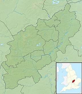 Arbury Hill Arbury Hill in Northamptonshire | |
| Location | Northamptonshire, England |
| OS grid | SP540587 |
| Topo map | OS Explorer 206 |
Arbury Hill, at 225 m (738 ft), is the joint highest point in the English county of Northamptonshire.[1] It is 9 km (5.6 mi) southwest of the town of Daventry.
The slopes of Arbury Hill are a drainage divide between three major river catchment areas, with the Nene to the north, east and south, the Cherwell (a tributary of the Thames) to the south-west and the Leam (a tributary of the Severn) to the west and north-west.
Earthworks
On the summit of Arbury Hill there are the vestiges of an Iron Age Fort (grid reference SP540587), although this is disputed. The remains are in the form of a square ditch and embankment about 200 metres across.[2]
There is a motor-cross track[3] on the east side and top of the hill that is used for competitions about three times a year.
Gallery
.JPG) The headwater of the River Nene, on the north east slope of Arbury Hill in 2008
The headwater of the River Nene, on the north east slope of Arbury Hill in 2008.JPG) The southern side of the hill in 2008
The southern side of the hill in 2008
References
- ↑ OS Explorer Map 207: Newport Pagnell & Northampton South (1:25 000) ISBN 0319 46387 7
- ↑ 'Badby', in An Inventory of the Historical Monuments in the County of Northamptonshire, Volume 3: Archaeological Sites in North-West Northamptonshire (London, 1981), pp. 7-12. British History Online, accessed 25 October 2017.
- ↑ moto-cross track
External links
| Wikimedia Commons has media related to Arbury Hill. |