A14 road (England)
| |
|---|---|
 | |
| Route information | |
|
Part of | |
| Length | 127 mi (204 km) |
| Major junctions | |
| From | M1 Junction 19 & M6 at Catthorpe |
|
[[Image:Motorway Left.svg|[ |x30px|link=]] [[Image:Motorway Left.svg|[ |x30px|link=]] [[Image:Motorway Left.svg|[ |x30px|link=]] [[Image:Motorway Left.svg|[ |x22px|link=]] | |
| To | Felixstowe |
| Location | |
| Primary destinations |
Rugby Kettering Huntingdon Cambridge Newmarket Bury St Edmunds Ipswich |
| Road network | |
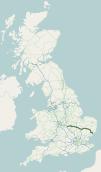
The A14 is a trunk road in England, running 127 miles (204 km) from the Port of Felixstowe, Suffolk to its western end at the Catthorpe Interchange; a major intersection at the southern end of the M6 and junction 19 of the M1 in Leicestershire. The road forms part of the unsigned Euroroutes E24 and E30.
Route
From the Port of Felixstowe the road heads west, bypassing Ipswich to the south via the Orwell Bridge and to Stowmarket, Bury St Edmunds, Newmarket and Cambridge where it meets the M11, then past St Ives, Huntingdon and the junction with the A1, from there through Kettering, Northamptonshire, ending at junction 19 of the M1 and the start of the M6.
The road is a dual carriageway, most with two lanes each way, but there are two dual three-lane sections: on the Newmarket bypass (between Junctions 36 and 38) where it runs concurrent with the A11, and a short stretch between the Girton Interchange and Bar Hill. There are three at-grade junctions: with the B663 at Bythorn in Cambridgeshire (junction 15); at the Leighton Bromswold turn a few miles to the east (junction 17); and at the Dockspur Roundabout at the edge of Felixstowe (junction 60), although at the A14/A1 junction (junction 21) and at the A14/A141 junction (junction 23), the road's main route does have to negotiate a roundabout (in the case of the latter, the A14 southbound and a spur goes underneath the roundabout, as the A1 does at the former).
History
The current A14 includes parts of the former A45 between Felixstowe and Cambridge, the A604 between Cambridge and Kettering, a short stretch of the former A6 west of Kettering, plus a new link road which was constructed in the early 1990s between there and the M1/M6 interchange at Catthorpe, Leicestershire. Prior to the current A14, the main route from Birmingham to the Haven ports followed the M6, M1, the A428 and A45 road via Coventry, Rugby, Northampton, Bedford, St Neots, Cambridge and then through all the towns on the A14 to Felixstowe. Prior to its use for the current route the A14 designation had been used for a section of road between the A10 at Royston and the A1 at Alconbury following part of the route of Ermine Street which now, in most parts, is designated the A1198.
The M45 motorway was constructed in 1959 parallel to part of the old A45 in the Midlands. It opened on the same day as the M1 motorway and was soon one of the busiest sections of motorway. The M6 opened in the late 1960s and early 1970s, after which more traffic to the ports used the route from junction 1 of the M6 via the A427 to Market Harborough followed by a short section of the A6 to Kettering and then the A604 to Cambridge before joining the old A45 to the ports as above.[1] The M45 now carries little traffic.
The sections from Huntingdon east to the ports were upgraded first, starting with the Huntingdon bypass in 1973, followed by the Girton to Bar Hill section in 1975/76 and the Cambridge northern bypass and Cambridge/Newmarket section in 1976/77.[2] The Bar Hill to Huntington section opened in 1979 prior to the M11 which was fully opened in 1980.[3] The Ipswich southern bypass including the Orwell Bridge opened in 1982.[4]
The M1-A1 link road was constructed between 1989 and 1991 following a lengthy period of consultation. The first inquiry was in 1974 and then a series of inquiries for sections of the preferred route from September 1984 until June 1985, during which objections came from some 1,130 sources. Subsequent public inquiries were held regarding Supplementary Orders. The route close to the site of the Battle of Naseby was particularly difficult and was taken to the High Court.[5] The link was opened by John MacGregor, Transport Secretary on 15 July 1994.[6]
Work to create a compact grade-separated junction (Junction 45/Rougham) and to re-align a 2-mile (3.2 km) stretch of carriageway was completed in 2006.[7]
Vehicles over 7.5 tonnes traveling east were banned from using the outside lane on a dual 2-lane section on a 2-mile (3.2 km) steep climb to Welford summit close to Junction 1 (A5199) from spring 2007; a similar scheme covered 2 miles (3.2 km) of the westbound carriageway from Junction 2, including a particularly steep climb to Naseby summit. The bans are active between 6am and 8pm and are intended to reduce delays to other traffic from lorries attempting to pass on these climbs.[8]
Between 2007 and 2008 a new section of two-lane dual carriageway was constructed at the Haughley Bends, one of Suffolk's most notorious accident blackspots,[9] to rationalise access using a new grade-separated junction.[10] The road opened in the summer of 2008[10] with some associated local works being completed early in 2009.[11]
Variable Message Signs (VMS), traffic queue detection loops and closed circuit TV (CCTV) were installed at a cost of 58m euros during 2009 to 2010[12][13][14] Both carriageways between Junction 52 (Claydon) and Junction 55 (Copdock) were refurbished during 2010 at a cost of £9 million. Work was being carried out a year earlier than scheduled as part of a UK government’s fiscal stimulus package.[15]
The Cambridgeshire Guided Busway connecting Cambridge, Huntingdon and St Ives, which opened in 2011 was intended to remove 5.6% of traffic using that section of the A14 (rising to 11.1% with the new Park & Ride sites), although as other traffic re-routes to the freed-up road space from other parts of the local road network, the net reduction is predicted to be 2.3%.[16]
The Felixstowe and Nuneaton freight capacity scheme, designed to take more lorry traffic off the A14 between the Port and the Midlands by increasing rail capacity and allowing the carriage of larger 'Hi-cube' shipping containers by widening to the W10 loading gauge, opened in 2011.[17]
Junction 55 (Copdock interchange) to the south of Ipswich was signalisation in 2011, along with lengthening the off-slip from the A1214.[18][19] The section around Kettering between Junctions 7 and 9 was widened to three lanes between November 2013 and April 2015 at a cost of £42m.[20]
After initially being shelved in 2010,[21] the Catthorpe Interchange at the road's Western terminus underwent a massive restructuring in 2014.[22] The redesigned junction was intended to allow free-flowing traffic movement between the A14, the southern terminus of the M6 motorway and Junction 19 of the M1 motorway. The first part opened in September 2016,[23] and the upgrade was completed three months later.
Diagram
A14 spur designation, including A1(M), A14(M), A604(M)
From the A12 west of Ipswich to the M1/M6 junction, the A14 is part of (but not signed as) the E-road E 24. From Ipswich to Felixstowe is part of E 30.
The numbering of the A14 is inconsistent with the national road numbering scheme, as it begins in zone 5 and crosses through zone 6 on the way to zone 1 east of Huntingdon to Felixstowe. The road is concurrent with the A12 road from the Seven Hills Interchange to the Copdock Interchange which forms the Ipswich Southern bypass and with the A11 road between junctions 36 and 38.
The final 1.2 mile section of the A14 'spur' from the junction with the B1043 near Huntingdon to the A1(M) at Alconbury has many inconsistent designations. It is the only section of the original A14 (A1198 road) that still bears that A14 designation; it was renumbered A604 for a period prior to the construction of the current A14. The scheme page on the Highways Agency website for the 'A1(M) Alconbury to Peterborough' scheme carried out in 1996–1998 refers to it as the A14(M),[26] but the map page linked from that page marks it as the A604(M).[27] The statutory instrument for the construction of the road in 1993 also refers to it as the A604(M).[28] Neither the A14(M) nor the A604(M) designation is used on the ground; heading onto the A1(M) heading north there a bare 'motorway' sign just past the B1043 exit without any number (see photo in the top right of this page).[29] However, when heading south along the A1 it is signed as 'A14'.[30] Online mapping is also inconsistent – the Highway Agency mapping (which uses Navteq data) refers to it as the 'A14(M)',[31] Bing maps (which also uses Navteq mapping) shows it as motorway without any designation[32] and Yahoo maps (which uses Navteq data) shows it as motorway and as the A1(M). Google maps (which uses TeleAtlas data) shows it as a trunk road called A14.[33]
East of the Girton Interchange with the M11 at Cambridge, the A14 used to be the A45, and much of the long-distance traffic further west had previously used the A45 route. The section between Cambridge and Kettering used to be the A604, apart from a short section near Kettering that used to be part of the A6. The road which was the A14 until the late 1980s is now the A1198 between Royston, Hertfordshire and Godmanchester. North of Godmanchester the route of the original A14 became part of the A604, itself now part of the new A14 until it meets the A1 road near Alconbury, thus forming a 'spur' off the A14.
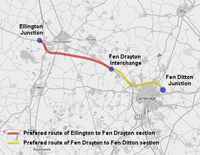
A14 Cambridge to Huntingdon Improvement Scheme
 A14 Ellington to Fen Ditton | |
| Location | Cambridgeshire |
|---|---|
| Proposer | Highways England |
| Cost estimate | £1.2-1.8b |
| Start date | 2017 |
| Completion date | 2020 |
The plan, originally called the 'A14 Ellington to Fen Ditton' was to include widening from Fen Ditton to Fen Drayton, broadly on the existing alignment and then on a new route from Fen Drayton to the south of the current road to the Brampton Interchange before tracking the A1 north to Ellington.[34]
The Highways Agency unveiled its plans in March 2005.[35] Details of the preferred route for the Fen Drayton to Fen Ditton section were published in March 2007. The contract was awarded to Costain Skanska Joint Venture on 28 January 2008,[34] which worked on detailed plans and the Highways Agency before publishing a draft order. The scheme was expected to open in stages between 2015 and 2016. The Highways Agency estimated that the Ellington-Fen Ditton widening would cost between £690 million and £1.2 billion, making it the most expensive scheme in their roads programme.[36]
In October 2009 the cost estimate had risen to £1.3b with work due to start in 2012 and being completed in winter 2015/2016.[37] The Campaign for Better Transport was opposed to the plans, listing their reasons for objection as the carbon emissions the road would induce, the cost, and its negative impact on non-car travel.[38] The coalition government suspended the scheme when it came into power, with Philip Hammond, the Secretary of State for Transport, suggesting that the scheme would be 'axed', and that the only way it would get built was as a toll road.[39] That government money would not pay for the scheme was confirmed at the end of October, when Roads Minister Mike Penning said that the scheme was unaffordable and no longer offered acceptable value for money.[40] The scheme was officially cancelled in 2010.[41]
In 2011 the government announced an 'A14 Challenge' inviting people to present proposals for the route.[42] The revised scheme, now known as the 'A14 Cambridge to Huntingdon Improvement Scheme' involves widening of the A1 between Brampton and Alconbury, a new Huntingdon Southern Bypass, widening of the existing A14 from Swavesey to Milton, and a new local access road between Swavesey and Girton. The A14 viaduct in Huntingdon town centre will become redundant and will be demolished. In November 2012 it was reported that the scheme might be back on a fast track to implementation[43] and it was mentioned in the June 2013 spending review.[44] The project was approved by the Secretary of State for Transport in May 2016. Work is due to be complete by March 2021 at a cost of £1.2-1.8b.[45]
Longer term plans
The Highways Agency has plans to increase capacity from Junctions 3 to 10 near Kettering 'in the longer term'[46] and also to widen the road throughout Northamptonshire to "help cut the number of accidents and cope with the likely growth in traffic".[47]
Coach services
The A14 is no longer used by a coach service, National Express route 350 (Clacton on sea to Liverpool) between Copdock (J53) and Huntingdon (J26); National Express 305 (Liverpool to Southend-on-sea) and route 314 (Southport to Cambridge) follow the old A45 between Cambridge and Birmingham.
Notable incidents
- 17 November 1998. A lorry collided with the petrol station between Bar Hill and Lolworth. The incident happened shortly after 11am and one person was killed and many others injured. The road was closed and there were huge tailbacks.[48]
- 26 July 2006. The A14 was closed for 24 hours near Newmarket when a van carrying acetylene gas canisters caught fire and the rescue services were advised by British Oxygen that they could remain unstable and would need 24 hours to cool. Bomb disposal officers were called in and the Red Cross set up a centre in Newmarket for those who were stranded.[49]
In popular culture
Ed Sheeran mentions the A14 in his song 'Eraser' on his 2017 album ÷.
References
- ↑ The Hamlin Road Atlas of Great Britain – 1976
- ↑ "A14. M1 to Felixstowe – Statistics and options". Archived from the original on 21 February 2012.
- ↑ "M11 London-Cambridge Motorway". Motorway Archive. Archived from the original on 11 August 2011. Retrieved 2010-02-06.
- ↑ "Appendix". Suffolk County Council. Archived from the original on 11 August 2011. Retrieved 12 October 2009.
- ↑ "A14/M1 to Felixstowe". Motorway Archive. Archived from the original on 21 July 2011. Retrieved 2010-02-06.
- ↑ "The A14 M1-A1 link will be opened on Friday 15 July by John MacGregor, Secretary of State for Transport and." Local Government Chronicle.
- ↑ "Cavities could be problem at A14 Rookery crossroads, Rougham". Bury Free Press.
- ↑ Highways Agency. "A14 Journey Time Trial" (PDF). Archived from the original (PDF) on 5 June 2011.
- ↑ "Haughley Bends transformation under way". 2007-09-28. Retrieved 2015-01-08.
- 1 2 "Highways Agency". Stowmarket to Haughley New Street improvement works. Archived from the original on 19 January 2008. Retrieved 18 June 2007.
- ↑ "Minister praises A14 safety bid". Evening Star. 2007-09-21. Retrieved 2008-01-20.
- ↑ "A14 Corridor Traffic Management Scheme". Highways Agency. Archived from the original on 5 June 2011.
- ↑ "A14 Corridor Traffic Management Scheme – 2009-UK-13027-E -Part of Priority Project 13" (PDF). Retrieved 2010-02-16.
- ↑ "Overnight closures on A14 in Suffolk for new road signs". BBC News. 2010-09-20. Archived from the original on 22 September 2010. Retrieved 2010-10-13.
Drivers have been warned about road closures on part of the A14 in Suffolk this week as work is carried out to install new electronic sign
- ↑ "Work starts early on £9m safety improvement scheme on A14 near Ipswich". Retrieved 2010-02-16.
- ↑ Dr Chris Gossop (2006-02-07). Cambridgeshire Guided Busway: Inspectors Report. Department for Transport. p. 29. Archived from the original on 2008-10-23. Retrieved 2008-05-16.
- ↑ "Felixstowe – Nuneaton".
- ↑ "Delays to Copdock Mill roundabout "improvements" welcomed".
- ↑ A14/A12 Copdock Roundabout, Ipswich, Highway Improvements - Highways Agency
- ↑ "A14 Junctions 7-9 Kettering Bypass Improvement". Highways England.
- ↑ "Catthorpe Interchange motorway access scheme is shelved". BBC News. 2010-06-18. Archived from the original on 6 October 2010. Retrieved 2010-11-18.
- ↑ "M1 Junction 19 Improvement Scheme", Highways Agency, accessed 2014-01-01
- ↑ Healy, Tim (17 September 2016). "Catthorpe interchange M6 to M1 link to open as £191 million project progresses". Leicester Mercury. Archived from the original on 26 September 2015. Retrieved 3 February 2017.
- ↑ "East of England roadworks update: Monday 19 March to Sunday 25 March 2007" (Press release). Highways Agency. 2007-03-16. Archived from the original on 30 September 2007. Retrieved 2007-03-16.
- ↑ "Google Maps". Retrieved 2009-10-30.
- ↑ "A1(M) Alconbury to Peterborough". Highways Agency. Archived from the original on 27 August 2011.
the remainder constructed to dual 3 lane motorway, except for the short length of A14(M) which is dual 2 lane motorway
- ↑ "A1(M) Alconbury to Peterborough". Highways Agency. Archived from the original on 20 December 2010.
- ↑ "Statutory Instrument 1993 No. 2940: The A604(M) Motorway (Alconbury to A1(M) Section) And Connecting Roads Scheme 1993".
- ↑ "A14(M)".
- ↑ "A14(M)".
- ↑ "Map". Highways Agency. Archived from the original on 2 December 2011.
- ↑ "Alconbury, Cambridgeshire".
- ↑ "Alconbury".
- 1 2 Highways Agency. "A14 Ellington to Fen Ditton". Archived from the original on 31 January 2008.
- ↑ "A14 Ellington to Fen Ditton Consultation". BBC Cambridgeshire. 2006-06-06. Retrieved 2008-01-20.
- ↑ "Updated scheme cost estimates" (PDF). Department for Transport. Archived from the original (PDF) on 18 July 2009. Retrieved 2009-09-30.
- ↑ "Anger as A14 revamp faces new delay". Archived from the original on 2012-07-28.
- ↑ "Newsletter 103, October 2009". Cambridgeshire Campaign for Better Transport. Retrieved 2009-11-17.
- ↑ "Minister hints at ditching £1.2bn A14 upgrade". 2010-10-13. Retrieved 2010-10-13.
“Take the A14,” he is quoted as saying, “I can’t find the money to improve that but, if the private sector wants to build a new road and toll it, [then great].”
- ↑ Local Transport Today, Issue 557, page 1
- ↑ A14 Cambridge to Huntingdon Improvement Scheme, Highways England, accessed 2015-01-03
- ↑ "Highways Agency announces stop-gap solution for A14".
- ↑ "Minister hints at A14 fast track". Archived from the original on 20 November 2012.
- ↑ Sparrow, Andrew (23 June 2013). "George Osborne to offset further spending cuts with capital investment". The Guardian. London.
- ↑ "A14 Cambridge to Huntingdon Improvement Scheme". Highways England.
- ↑ "14 Kettering Bypass Widening". Highways Agency. Archived from the original on 19 December 2010.
- ↑ "Traffic may force widening of A14". BBC News. 2004-11-24. Retrieved 2008-01-20.
- ↑ "Man killed in petrol station fire". BBC News. 1998-11-17. Retrieved 2010-04-23.
- ↑ "Burning van causes A14 disruption". BBC News. 2006-07-27. Retrieved 2008-01-20.
External links
![]()
- GO East CHUMMS page containing links to the report documents
- Public consultation on Huntingdon Bypass (March 2007)
A roads in Zone 1 of the Great Britain road numbering scheme | ||
|---|---|---|
| ||