Kotamobagu
| Kotamobagu | ||
|---|---|---|
| City | ||
| ||
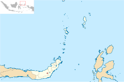 Location within North Sulawesi | ||
| Coordinates: 0°44′N 124°19′E / 0.733°N 124.317°ECoordinates: 0°44′N 124°19′E / 0.733°N 124.317°E | ||
| Country |
| |
| Province |
| |
| Government | ||
| • Mayor | Tatong Bara | |
| • Vice Mayor | Jainuddin Damopolii | |
| Population (2010) | ||
| • Total | 107,459 | |
| Time zone | UTC+8 (Indonesia Central Time) | |
| Area code | (+62) 434 | |
| Website | Kotamobagu government website | |


Kotamobagu is a city in North Sulawesi, Indonesia. It has a population of 107,459 (2010).[1]
Administration
The City is divided into four districts (kecamatan), tabulated below with their 2010 Census population:[2]
| Name | English name | Population Census 2010 |
|---|---|---|
| Kotamobagu Selatan | (South Kotamobagu) | 28,030 |
| Kotamobagu Timur | (East Kotamobagu) | 26,355 |
| Kotamobagu Barat | (West Kotamobagu) | 37,678 |
| Kotamobagu Utara | (North Kotamobagu) | 15,396 |
Autonomy
As an autonomous area, in 2011 Kotamobagu was judged the best autonomous area from among 57 autonomous areas which have been formed by central government since 2007.[3]
References
- ↑ (in Indonesian) Jumlah Penduduk Sulawesi Utara Tahun 2010 Archived 2011-11-28 at the Wayback Machine.
- ↑ Biro Pusat Statistik, Jakarta, 2011.
- ↑ "Kotamobagu Daerah Otonom Terbaik". March 22, 2012.
External links
This article is issued from
Wikipedia.
The text is licensed under Creative Commons - Attribution - Sharealike.
Additional terms may apply for the media files.