Kurnool
| Kurnool Kandanavooru | |
|---|---|
| Nickname(s): The Gateway of Rayalaseema | |
 Kurnool Location in Andhra Pradesh and in India  Kurnool Kurnool (India) | |
| Coordinates: 15°50′N 78°03′E / 15.83°N 78.05°ECoordinates: 15°50′N 78°03′E / 15.83°N 78.05°E | |
| Country |
|
| State | Andhra Pradesh |
| District | Kurnool |
| Government | |
| • Type | Municipal corporation |
| Area[1] | |
| • City | 69.51 km2 (26.84 sq mi) |
| Area rank | 105 |
| Elevation | 274 m (899 ft) |
| Population (2011)[2] | |
| • Rank |
106th (India) 5th (Andhra Pradesh) |
| • Urban | 430,214 |
| • Rural | 56,759 |
| • Metro[3] | 486,973(KUDA) |
| Languages | |
| • Official | Telugu Urdu |
| Time zone | UTC+5:30 (IST) |
| PIN | 518001, 518002, 518003, 518004, 518005, 518006, 518007 |
| Vehicle registration | AP-21[4] |
| Website | Kurnool Municipal Corporation |
Kurnool is the headquarters of Kurnool district in the Indian state of Andhra Pradesh.[5] The city is often referred as The Gateway of Rayalaseema.[6] It was the capital of Andhra State from 1 October 1953 to 31 October 1956. As of 2011 census, it is the fifth most populous city in the state with a population of 460,184.[7][8]
Etymology
The name Kurnool is derived from Kandanavooru or Kandanavolu. The name Kandanavolu is combination of Kandana and volu. Kandana means grease. During the days when Bullock Cart is a form of transport, bullock cart riders used to stop on the banks of Tungabhadra River to apply grease to the bullock cart wheels before crossing the river. Hence the name 'Kandanavolu'.[9] Later the name formerly Kandanavolu changed to Kandanavooru, and then gradually to Kurnool.
History
Palaeolithic era
The Ketavaram[10] rock paintings from the Paleolithic era and are (18 kilometres from Kurnool). Also the Jurreru Valley, Katavani Kunta[11] and Yaganti in Kurnool District have some important rock art and paintings in the vicinity, may be dated from 35,000 to 40,000 years ago.
Belum Caves are geologically and historically important caves in the district. There are indications that Jain and Buddhist monks were occupying these caves centuries ago. Many Buddhists relics were found inside the caves. These relics are now housed in Museum at Ananthapur. Archaeological survey of India (ASI) found remnants of vessels and other artifacts of pre-Buddhist era and has dated the remnants of vessels found in the caves to 4500 BC.[12]
Early feudal era
Little was known about Kurnool town before the 11th century. The earliest knowledge of this settlement dates from the 11th century. It has developed as transit place on the southern banks of the river Tungabhadra. It was ruled by Cholas and later by Kakatiya kings in the 12th and 13th centuries.
During the 17th century it was ruled by Gopal Raja. The Pathan general Abdul Wahab conquered king Gopal Raja and ruled over the country for 16 years.
Mughal princely state
The town became a vassal princely state of the Mughal empire under Aurangazeb, who took control in 1686. The town was the capital and seat of ruling Muslim princes, styled Nawabs:[13]
- 14th to the 16th century: historical interest are the ruins of a royal fort dating back to the medieval kingdom of Vijayanagar, which flourished from the 14th to the 16th century
- 1674 -1703 : Nawab Khizr Khan Panni
- 1703 – 1710: Nawab Daud Khan Panni
- 1710 – 1724: Nawab Ibrahim Khan
- 1724–1733: Nawab Alaf Khan 1
- 1733–1751: Himayat Bahadur Khan
- 1751–1792: Nawab Ranmust Khan
- 1792 – 1815: Nawab Alaf Khan 11
- 1815–1823: Nawab Munawar Khan
- 1823–1839: Nawab Ghulam Rasul Khan ( The Last Independent Ruler of Kurnool)
The Royal Title, legacy and eminence of the Kurnool Nawabs continued after the siege in 1839. Nawab Dawood khan Panni succeeded Nawab Ghulam Rasul khan who was succeeded by Nawab Shuja Ul Mulk . Nawab Shuja Ul Mulk had four sons and two daughters namely Nawab Dawood khan II, Nawab Alaf Khan, Nawab Anis ul Mulk and Nawab Azam Ali Khan. Most of the royal descendants eventually migrated from India to Pakistan, UAE and USA.
Post independence
Nawab Dawood Khan was the heir to the Royal Title during the Partition of India in 1947. He studied in UK and Aligarh Muslim University in India, he was also active in the freedom movement in Aligarh. Nawab Dawood Khan immigrated to Pakistan after the end of British Raj. Amongst the current royal descendants is Nawab Colonel Asad Ullah Khan eldest son of Nawab Dawood Khan. Nawab Asad Ullah received the Sword of Honor (finest graduating cadet award) at the Pakistan Military Academy and is a war veteran of the Indo-Pakistan War of 1971. His three brothers Nawab Alaf khan, Nawab Anis ul Mulk and Nawab Azam Ali khan decided to stay back in India and are succeeded by the current generation of the nawabs of Kurnool Family. Nawab Alaf khan a towering and handsome personality excelled in business and football . His eldest son Nawab Shaji Ul Mulk is the current chairman of MULK HOLDINGS a multinational conglomerate and ranked Number 9 by FORBES in the Top Indian Leaders in the Middle East . His other two brothers Nawab Shafi Ul Mulk ( Also listed in the Forbes top 100 Indian Leaders ) and Nawab Amair Ul mulk are established business men in Dubai . Afshan Quereshi, Anjuman Ameen and Farzan Naveen are the three daughters of the late Nawab Alaf khan.
Kurnool city served as the capital of Andhra State from 1953–1956, until in 1956, the Telangana region was merged with Andhra State to form Andhra Pradesh state, and its capital was shifted from Kurnool to Hyderabad as there were only camps like A-Camp,B-Camp,C-Camp etc., and due to lack of capital city infrastructure in kurnool for good governance and Hyderabad was already a well established capital with city infrastructure and well-governing facilities were there in Hyderabad as the city served as the capital city to the princely state of Asaf Jahis from 1763–1948 and as a capital city to the Hyderabad State from 1948–1956 .[14][15]
Geography and climate
Location
Kurnool is located at 15°50′00″N 78°03′00″E / 15.8333°N 78.05°E.[16] It has an average elevation of 273 metres (898 feet).
Kurnool lies on the banks of the Tungabhadra River. The Hundri and Neeva rivers also flow through the city. The K.C.Canal (Kurnool–Cuddapah) was built by the Dutch for transportation, but later used for irrigation.
Cityscape

Landmarks in and around the city include Konda Reddy Fort Formerly called Kondareddy Burj is the Historical Monuement and Major Tourist Attraction of Kurnool located at the north east part of the city.[17] Orvakal rock Garderns is the Sculpture Garden with Ancient cave lies on the South East of the city.[18]
Climate
The climate is tropical with temperatures ranging from 26 °C (78.8 °F) to 46 °C (114.8 °F) in the summer and 12 °C (53.6 °F) to 31 °C (87.8 °F) in the winter. The average annual rainfall is about 705 millimetres (28 in).
| Climate data for Kurnool (1981–2010) | |||||||||||||
|---|---|---|---|---|---|---|---|---|---|---|---|---|---|
| Month | Jan | Feb | Mar | Apr | May | Jun | Jul | Aug | Sep | Oct | Nov | Dec | Year |
| Record high °C (°F) | 37.3 (99.1) |
39.9 (103.8) |
42.6 (108.7) |
44.8 (112.6) |
46.5 (115.7) |
42 (108) |
38.5 (101.3) |
37.8 (100) |
38.7 (101.7) |
38.4 (101.1) |
38.8 (101.8) |
34.4 (93.9) |
46.5 (115.7) |
| Average high °C (°F) | 31.7 (89.1) |
34.8 (94.6) |
38.2 (100.8) |
40.1 (104.2) |
40.5 (104.9) |
36.2 (97.2) |
33.6 (92.5) |
32.5 (90.5) |
32.9 (91.2) |
32.5 (90.5) |
31.2 (88.2) |
30.5 (86.9) |
34.6 (94.3) |
| Average low °C (°F) | 17.9 (64.2) |
20.3 (68.5) |
23.8 (74.8) |
26.7 (80.1) |
27.5 (81.5) |
25.5 (77.9) |
24.5 (76.1) |
23.9 (75) |
23.8 (74.8) |
22.8 (73) |
20.1 (68.2) |
17.8 (64) |
22.9 (73.2) |
| Record low °C (°F) | 8.3 (46.9) |
11.1 (52) |
12.8 (55) |
15.5 (59.9) |
19.4 (66.9) |
17.6 (63.7) |
19.2 (66.6) |
19.9 (67.8) |
17.0 (62.6) |
13.0 (55.4) |
9.3 (48.7) |
6.7 (44.1) |
6.7 (44.1) |
| Average precipitation mm (inches) | 4.0 (0.157) |
2.2 (0.087) |
9.8 (0.386) |
26.4 (1.039) |
50.4 (1.984) |
93.6 (3.685) |
121.4 (4.78) |
143.4 (5.646) |
145.0 (5.709) |
114.1 (4.492) |
23.0 (0.906) |
3.9 (0.154) |
737.2 (29.024) |
| Average precipitation days | 0.3 | 0.2 | 0.7 | 1.6 | 2.7 | 5.7 | 7.6 | 9.0 | 7.7 | 5.2 | 1.9 | 0.3 | 43.0 |
| Source: India Meteorological Department (record high and low up to 2010)[19][20] | |||||||||||||
Demographics
As per final data of 2011 census, Kurnool urban agglomeration had a population of 484,327. The literacy rate was 77.37 per cent. note: The Office of Registrar General & Census Commissioner of India. note: UA = Urban Agglomeration.
Politics
The present MLA from Kurnool is S.S.V.Mohan Reddy.[22]
Education
The primary and secondary school education is imparted by Government, aided and private schools of the School Education Department of the state.[23][24] Pre-schools by Anganwadi Centers of ICDS Dept. Famous institutions in kurnool are kurnool medical college and iiitdm Kurnool.
Transport
Roads
Kurnool is well connected by road with Hyderabad and Bengaluru. National Highway 44 (India) connects Kurnool to Hyderabad. The State Highway 51 connects to Srisailam, Vinukonda, Guntur, Vijayawada. National Highway 40 (India) (new numbering) runs from Kurnool to Chittoor are the major highways passing through the city. The city has a total road length of 519.22 km[25] State owned bus transport system, APSRTC, operates buses from Kurnool bus station to other parts of the state.[26][27]
Railways
Kurnool railway station lies on the Hyderabad – Guntakal railway line. It is classified as an A–category station in the Hyderabad railway division of South Central Railway zone.
Airport
The Ministry of Civil Aviation has proposed to develop Kurnool Airport, a greenfield airport near Orvakal, 25 km from Kurnool city. The airport in being built on 1,110 acres of land at a cost of Rs. 234 crores and is projected to be completed by mid July 2018.
Economy
Kurnool is endowed with good mineral resources. The important minerals are Iron ore, dolomite, limestone, ochre, quartz and silica.[28]
See also
References
- ↑ http://kurnool.cdma.ap.gov.in/
- ↑ "Andhra Pradesh (India): Districts, Cities, Towns and Outgrowth Wards – Population Statistics in Maps and Charts". citypopulation.de.
- ↑ "Andhra Pradesh (India): State, Major Agglomerations & Cities – Population Statistics in Maps and Charts". citypopulation.de.
- ↑ http://www.aptransport.org/html/registration-districtcodes.html
- ↑ "District Census Handbook : Kurnool" (PDF). Census of India. p. 50. Retrieved 21 August 2015.
- ↑ Sarkar, Siddhartha (2011). International Journal of Economic and Political Integration: Vol.1, No.1. Universal-Publishers. p. 15. ISBN 978-1-61233-544-5. Retrieved 18 July 2015.
- ↑ http://ourkmc.com/Circulars/files/50__Binder1.pdf
- ↑ "KURNOOL MUNICIPAL CORPORATION STATUS REPORT". Docslide.us.
- ↑ "Heritage in Kurnool". AP Tourism Department. Retrieved 10 August 2014.
- ↑ "Archived copy" (PDF). Archived from the original (PDF) on 17 December 2013. Retrieved 15 June 2014.
- ↑ Petraglia, Michael. "New rock art discoveries in the Kurnool District, Andhra Pradesh, India". academia.edu. Retrieved 28 May 2014.
- ↑ Show Caves of India: Belum Caves
- ↑ Cahoon, Ben. "Indian Princely States K-Z".
- ↑ "The Indian Express – Google News Archive Search". google.com.
- ↑ Somasekhar, Ch RS Sarma / M. "Capital loss: Madras, Kurnool, now Hyderabad". The Hindu Business Line. Retrieved 11 April 2016.
- ↑ "Maps, Weather, and Airports for Kurnool, India". fallingrain.com.
- ↑ "Gopal Darwaza stands as a witness to history". The Hindu. Kurnool. 22 April 2014. Retrieved 28 February 2016.
- ↑ Kurmanath, K.V (22 June 2006). "A rocky, solid gift from nature". The Hindu Business Line. Orvakal (Kurnool district). Retrieved 28 February 2016.
- ↑ "Kurnool Climatological Table Period: 1981–2010". India Meteorological Department. Retrieved 27 May 2015.
- ↑ "Ever recorded Maximum and minimum temperatures up to 2010" (PDF). India Meteorological Department. Archived from the original (PDF) on 21 May 2013. Retrieved 27 May 2015.
- ↑ "Census of India – Socio-cultural aspects". Government of India, Ministry of Home Affairs. Archived from the original on 20 May 2011. Retrieved 2 March 2011.
- ↑ "S V Mohan Reddy Joins 'Parent Party'".
- ↑ "School Education Department" (PDF). School Education Department, Government of Andhra Pradesh. Archived from the original (PDF) on 19 March 2016. Retrieved 7 November 2016.
- ↑ "The Department of School Education – Official AP State Government Portal | AP State Portal". www.ap.gov.in. Archived from the original on 7 November 2016. Retrieved 7 November 2016.
- ↑ "DETAILS OF ROADS IN EACH ULB OF ANDHRA PRADESH". Archived from the original on 1 August 2016.
- ↑ "Bus Stations in Districts". Andhra Pradesh State Road Transport Corporation. Archived from the original on 22 March 2016. Retrieved 8 March 2016.
- ↑ Krishnamoorthy, Suresh (22 April 2015). "Several bus stations lack CCTV surveillance". The Hindu. Hyderabad. Retrieved 8 March 2016.
- ↑ http://dcmsme.gov.in/dips/Kurnool%20dip%20%20amended%20march.pdf
External links
| Wikimedia Commons has media related to Kurnool. |

- Kurnool district Mandal Information
- http://www.goroadtrip.com/explore/india/andhra-pradesh/kurnool
| District headquarters | 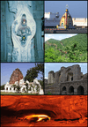 | |
|---|---|---|
| Divisions | ||
| Mandals | ||
| Cities | ||
| Towns | ||
| Census towns | ||