Guadalupita, New Mexico
| Guadalupita | |
|---|---|
| Unincorporated community | |
 Guadalupita Location within the state of New Mexico  Guadalupita Guadalupita (the US) | |
| Coordinates: 36°08′15″N 105°14′19″W / 36.13750°N 105.23861°WCoordinates: 36°08′15″N 105°14′19″W / 36.13750°N 105.23861°W | |
| Country | United States |
| State | New Mexico |
| County | Mora |
| Elevation | 7,566 ft (2,306 m) |
| Time zone | UTC-7 (Mountain (MST)) |
| • Summer (DST) | UTC-6 (MDT) |
| ZIP codes | 87722[1] |
| Area code(s) | 575 |
| GNIS feature ID | 915833[2] |
Guadalupita is an unincorporated community located in Mora County, New Mexico, United States. The community is located on New Mexico State Road 434 12.4 miles (20.0 km) north-northeast of Mora. Guadalupita has a post office with ZIP code 87722, which opened on November 25, 1879.[1][3]
References
- 1 2 United States Postal Service. "USPS - Look Up a ZIP Code". Retrieved November 30, 2014.
- ↑ "Guadalupita". Geographic Names Information System. United States Geological Survey.
- ↑ "Postmaster Finder - Post Offices by ZIP Code". United States Postal Service. Retrieved November 30, 2014.
Municipalities and communities of Mora County, New Mexico, United States | ||
|---|---|---|
| Village | 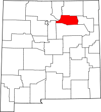 | |
| CDPs | ||
| Other unincorporated communities | ||
This article is issued from
Wikipedia.
The text is licensed under Creative Commons - Attribution - Sharealike.
Additional terms may apply for the media files.