Angul district
{{Infobox settlement
| name = Angul district
| native_name =
| native_name_lang = or
| other_name =
| nickname =
| settlement_type = District
| image_skyline =
| image_alt =
| image_caption =
| image_map = OrissaAngul.png
| image_seal=Seal of Odisha.png
| coordinates = 20°49′59″N 85°06′00″E / 20.833°N 85.1°ECoordinates: 20°49′59″N 85°06′00″E / 20.833°N 85.1°E
| subdivision_type = Country
| subdivision_name = ![]()
| Subdivisions: | 4 |
| Blocks: | 8 |
| Municipalities: | 2 |
| N.A.C.: | 2 |
| Tehsils: | 5 |
| Forest Coverage: | 2,716.82 km² |
| Villages: | 1,922 |
| Grama panchayat: | 180 |
| Towns: | 9 |
Angul District is an administrative and a municipal district, one of the thirty in the Odisha, India. The city of Angul is Angul district's headquarter.
Geography
Angul district (odia:ଅନୁଗୋଳ ଜିଲ୍ଲା) is located in the center of the state of Odisha and lies between 20° 31 N & 21° 40 N latitude and 84° 15 E & 85° 23 E longitude. The altitude is between 564 and 1187 metres.[2] The district has an area of 6232 km2. It is bounded by Dhenkanal and Cuttack district in the east, Deogarh, Kendujhar and Sundargarh district in north, Sambalpur and Sonepur in west and Boudh and Nayagarh in the south side. The district is abundant with natural resources. Angul, The district headquarters is about 150 kilometers from the state capital Bhubaneswar.
It is the hottest district in India where maximum temperature goes up to 550C during summer.
A study jointly conducted by Indian Institute of Technology, Delhi (IIT-D) and Central Pollution Control Board (CPCB) reveals that Angul district is among the top ten most polluted Indian cities where the pollution level reached to a 'very alarmingly' level.[3]
Divisions
The following is the list of blocks, tehsils and subdivisions in the district of Angul:
Subdivisions
Blocks
- Angul Sadar
- Athamalik Sadar
- Chhendipada
- Talcher Sadar
- Pallahada Sadar
- Banarpal
- Kishorenagar
- Kaniha
Tehsils
- Angul
- Athamalik
- Talcher
- Pallahada
- Chendipada
- Banarpal
- Kishorenagar
- Kaniha
Demographics
According to the 2011 census, Angul district has a population of 1,271,703,[4] roughly equal to the nation of Estonia[5] or the US state of New Hampshire.[6] This gives it a ranking of 380th in India (out of a total of 640).[4] The district has a population density of 199 inhabitants per square kilometre (520/sq mi) .[4] Its population growth rate over the decade 2001–2011 was 11.55%.[4] Anugul has a sex ratio of 942 females for every 1000 males,[4] and a literacy rate of 78.96%.[4]
History
| This article is part of a series on |
| Odisha |
|---|
 |
| Governance |
|
| Topics |
| GI Products |
|
Districts Divisions |
|
|
A bridge between western and coastal areas of Odisha where the prehistoric and protohistoric relics are found in the villages of Bhimakund, Kankili, Kulei, Samal, Sanakerjang, Kaliakata, Paranga, Kerjang, Ogi, Tikarapara and Pallahara. Rulers have been the Bhanjas of Angulaka-pattana, the Sulkis of Kodalaka Mandala, the Nandodbhavas of Airavatta Mandala, and the Tungas of Yamagartta Mandala.
Legend says that ancient angul was the land of tribals such as Gonds, Kandhas, Sabaras. Angul was divided into number of small feudals and all chieftains were independent. But the feudals were made to pay a tax to a king. One of the feudal kings named "Anu" started a rebellion against that bigger kingdom but the bigger king with the help of Mathura's Rajputs suppressed the rebellion. As there was a war between both party and in local language "war" is "Golmala" so the name derived Anugol=Anu+Gol(mala). Subsequently, this Anugol became Angul. The government named the area Angul in 1896.
The Bhaumakaras declined by the middle of the 10th century AD when the eastern part of Odisha including the Dhenkanal region passed to the hands of the Somavamsis of South Kosala. The Somavamsis in their turn, were ousted by the Gangas and Odisha was occupied by Chodagangadedva some time before 1112 AD. The Ganga rule lasted till 1435 AD when a new Solar dynasty founded by Kapilendradeva came to power.
About the year 1533, Govinda Vidyadhar put an end to the Suryavamsi rule and started the rule of Bhoi dynasty, which lasted up to 1559 when Mukundadeva, belonging to the Chalukya family, occupied the throne. In 1568, the Afghans of Bengal invaded Odisha, and defeated and killed Mukundadeva after which Odisha came under their occupation. During all this period of dynastic changes, Angul played no remarkable role in history and this territory simply passed from one political authority to the other. During the rule of Suryavamsis and the Bhois and subsequently some new feudal states developed as self-contained political units. These are Angul, Talcher, Pallahara and Athamallik.
Somanath Singh Jagadev was the last independent king of Angul and he ruled for 33 years from 1814 to 1847 when he was deposed by the government according to the Doctrine of Lapse. His imperial capital is Krushnadevagara, currently known as Purunagada village 15 km from Angul town. The ruins of his fort remain there inside the lush jungle of Purunagada.
The king's family deity or Kuladevata God Madanmohan temple is worshipped by villagers He incurred displeasure nor only among the neighbouring Feudatory Chiefs of Dhenkanal, Hindol, Daspalla, Baudh, and Athmallik but also among the British Officers by his head-strong dealings and outspoken nature. His state was confiscated by the government in their Resolution, dated 16 September 1848. Angul thus passed under the direct rule of the British and was administered by the Superintendent of the Tributary Mahals, through the agency of an officer known as Tehsildar, who collected revenue and administered justice, until 1891 when Angul was constituted a separate district. The statue of king Somanath Singh Jagadev is situated at the heart of Angul city.
The district was formally formed out of the former undivided Dhenkanal district on the date of 1 April 1993 by the Chief Minister of Odisha, Biju Patnaik.
Economy
Industries like the National Aluminium Company (NALCO), Mahanadi Coalfields Limited (MCL), National Thermal Power Corporation (NTPC), Jindal Steel and Power Limited (JSPL), Bhushan Steel etc. are situated in the district. This heavy industries along with a lot of small industries are contributing to the economic growth to state as well as countries GDP. East Coast Railway zone's highest earning railway station is Talcher Railway station.
Major Industries
NALCO (National Aluminium Company) is a blue chip company in the aluminium sector. NALCO is the largest integrated bauxite-alumina-aluminium complex in Asia. Nalco's 4.60 lac tpa capacity aluminium smelter and its 1200 MW captive power plant are located in Angul. Nalco's smelter came online in 1984. NALCOP manufacturing plants and township called Nalco Nagar are located at 5 km (3.1 mi) from Angul town, by the side of NH-55. Nalco manufactures primary aluminium metal in the form of ingots, wire rods, sow moulds, billets and strips. Nalco aluminium is exported to 30 countries.
NTPC (National Thermal Power Corporation) has two power plants in Angul district. NTPC/TTPS is located 7 km (4.3 mi) from Talcher on the way to Bhubaneswar (460 MW). NTPC/TSTPS, also known as NTPC Kaniha (3000 MW) is located at Kaniha, 60 km (37 mi) from Angul. The company has a township for its 1,500 employees. The beneficiary states from the power generation are Odisha, Bihar, Sikkim, Damodar Valley Corporation, West Bengal, Jharkhand and southern states. Coal for the power plant is sourced from the Talcher Coal Field and water for thermal power is taken from Samal Barrage Reservoir.
MCL (Mahanadi Coalfields Limited) is located in Talcher, around 20 km (12 mi) from Angul. It is a unit of Coal India Limited, MCL was previously under SECL (South Eastern Coal Field). The major mines under MCL are the Ananta Colliery, Dera Colliery and Balanda Colliery.
FCI (Fertilizer Corporation of India) has its unit in Talcher, Angul. One of the oldest industries of this area, FCI Talcher has faced problems in its viable operation and the plant has faced closure since 1998. The township and plants do exist, waiting for revival. RCF (Rashtriya Chemicals and Fertilizers) plans to revive the FCI plant in Talcher with a capital outlay of about ₹30 billion (US$420 million).
HWP (the Heavy Water Plant) located in Talcher is a government of India organisation under the aegis of the Ministry of Atomic Power and Energy. The plant is involved in the production of organic solvents like TBP, D2EFHA, TAPO & TOPO, required as a part of the nuclear power program of the country.
TTPS (Talcher Thermal Power Station) was one of the oldest power generation plants of the government of Odisha, with a capacity of 460 MW . It is located in Talcher. Coal for the plant is sourced from the Talcher Coal Field and water for the thermal power is taken from nearby Brahmani river. The company was taken over by and run by NTPC since 1998.
JSPL (Jindal Steel and Power) is a major industry which has come up in Angul district with a capital investment of ₹200 billion (US$2.8 billion) for setting a steel producing facility and a 1,500 MW power generation unit. JSPL plans to commission the first phase of its 6 million tonne per annum (MTPA) steel plant in Angul district by mid-2014. In the first phase, it will have a capacity of 1.8 MTPA.
BSSL (Bhushan Steel) is in the process of setting up a power plant and an advanced hot rolling plant on 1,618 acres (6.55 km2) at Angul, at a cost of ₹52 billion (US$720 million). It is in talks with the state government for the allotment of additional 3,500 acres (14 km2) to enable it to triple the planned capacity of 2.2 million tonnes (mt) in about five years. The Angul plant has already started producing 110 MW, sponge iron and billets production is close to 0.5 million tonnes.
Places of interest
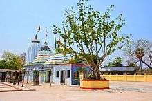
Budhi Thakurani Temple
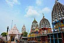
Built on a hill, the Budhi Thakurani Temple attracts national as well as foreign tourists to the state. Nearby, is a huge Jagannath Temple, known as Saila Srikhetra. This Jagannath Temple is the exact replica of Jagannath Temple, Puri.
Tikarapada
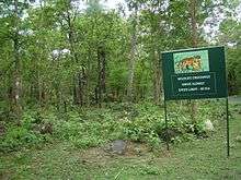
It is 60 km from the district headquarters and 200 km from Bhubaneswar. It is famous for the Gharial Crocodile Sanctuary, which is situated on the bank of River Mahanadi. Wildlife lovers can watch tiger, leopard, elephant, gaur, sambar, spotted deer, mouse deer, nilagai, four-horned antelope and sloth bear. Wild dogs used to be sighted often. Reptiles seen include the Gharial, mugger crocodile, fresh water turtle. Poisonous and non-poisonous snakes can be sighted. The site is popular as a trekking hotspot. Tikarapada is also famous for the Satkosia Tiger Reserve, and its lush green forest.
Bhimkund
Bhimkund is a tourist place, situated about eight kilometers from the town of Talcher. The sleeping statue of Lord Vishnu can be seen on the river bed of Brahmani.
Khuludi
Coordinates: 21°26'16"N 85°15'25"E
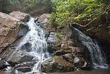
The Shiva temple under the foothills of Malyagiri (also known as Malayagiri) is a place of pilgrimage for the people of the district. Lord Shiva abodes here under the name of Girishwara, meaning the Lord of the Mountains. The word Girishwara forms combining Giri(Mountain) and Ishwara (God). The waterfall near the temple is an attraction it is a small one with a height of 10–12 feet. The Khuludi village is 25 km from Pallahara, 104 km from the district headquarter Angul via National Highway 23 (India) and 153 km from Ispat city Rourkela via SH-10A and National Highway 23 (India) .
Deulajhari
Deulajhari, better known as the ancient citadel of Saivism, is a temple set within indigenous-jasmine forest (locally known as Kiabana) that stands as the high walls. To the south of the temple flows the sacred river Chitrotpala, and in the north stands the towering hills of Panchadhara. Hot springs surround the temple. As per the ancient records, there were eighty-four such hot springs in and around the place. But as of now there are 24 springs still active. The most popular springs are Agnikunda, Taptakunda, Himakunda, Amrutakunda and Labakusakunda. The temperature of water in these springs varies from 40 °C Celsius to 62 °C.
Balipatta
The distance from the dist headquarter is 40 kilometers and is situated on the bank of River Singida. A high school is in the area. Covered with huge forest and Dimiri-Kuda Pahada(Mountain), Elephants graze around the area which is surrounded by water and crops There is also a dam known as Kansa-Bansa . Main pilgrim place is Kundeswari Pitha(in Kundaana Jharana Forest)and Siva Mandira . The whole Panchayat is famous for the Cultivation of Valia(Cashew),Amba(Mango),Kadali Banana(Banana),Dhana(Rice),Putala (Parwal),Kobi,Muga Dali,Harada Dali,Mahula etc.
Kukurpeta
It is near to Angul, 35 kilometers from district headquarters. There is a dam named as kpt mip located in the village. The 'kukurpeta mountain is in the village.
Politics
Legislative Assembly Constituencies
The following are the five Vidhan sabha constituencies[7][8] of Angul district and the elected members[9] of the Angul district:
| No. | Constituency | Reservation | Extent of the Assembly Constituency (Blocks) | Member of 14th Assembly | Party |
|---|---|---|---|---|---|
| 59 | Pallahara | None | Pallahara, Kaniha (part) | Mahesh Sahoo | BJD |
| 60 | Talcher | None | Talcher (M), Talcher, Kaniha (part) | Braja Kishore Pradhan | BJD |
| 61 | Angul | None | Angul (M), NALCO (C. T), Angul (part), Banarpal (part) | Rajani Kant Singh | BJD |
| 62 | Chhendipada | SC | Chhendipada, Banarpal (part) | Sushanta Behera | BJD |
| 63 | Athmallik | None | Athmallik (NAC), Athmallik, Kishorenagar, Angul (part) | Sanjeeb Kumar Sahoo | BJD |
Lok Sabha constituencies
Since 2008, Angul district is represented in Dhenkanal (Lok Sabha constituency) and Sambalpur (Lok Sabha constituency).
Angul (Lok Sabha constituency) does not exist in 1952 general elections to 1st Lok Sabha. However it is created from 2nd till 5th Lok Sabha during 1957 till 1976. Badakumar Pratap Gangadeb got elected in 1957 and 1971 for 2nd and 5th Lok Sabha while Harekrushna Mahatab was elected in 1962 to 3rd and D. N. Deb was elected in 1967 to 4th Lok Sabha. Angul Seat ceased after the creation of Deogarh (Lok Sabha constituency) in 1977 from 6th Lok Sabha. Deogarh seat was also delimited in 2008.[10]
References
- ↑ "Anugul (Angul) District Population Census 2011, Orissa literacy sex ratio and density". census2011.co.in. Archived from the original on 6 January 2015. Retrieved 9 February 2015.
- ↑ "Census of India 2001: Data from the 2001 Census, including cities, villages and towns (Provisional)". Census Commission of India. Archived from the original on 16 June 2004. Retrieved 1 November 2008.
- ↑ "Angul-Talcher seventh most polluted industrial cluster in the country". The Hindu. 5 January 2010.
- 1 2 3 4 5 6 "District Census 2011". Census2011.co.in. 2011. Archived from the original on 11 June 2011. Retrieved 30 September 2011.
- ↑ US Directorate of Intelligence. "Country Comparison:Population". Archived from the original on 27 September 2011. Retrieved 1 October 2011.
Estonia 1,282,963 July 2011 est.
- ↑ "2010 Resident Population Data". U. S. Census Bureau. Archived from the original on 19 October 2013. Retrieved 30 September 2011.
New Hampshire 1,316,470
- ↑ "Assembly Constituencies and their EXtent" (PDF). Archived (PDF) from the original on 5 March 2016. Retrieved 28 February 2013.
- ↑ "Seats of Odisha". Archived from the original on 5 March 2016. Retrieved 28 February 2013.
- ↑ "List of Member in Fourteenth Assembly". ws.ori.nic.in. Archived from the original on 2 May 2007. Retrieved 19 February 2013.
MEMBER NAME
- ↑ "All Members of Lok Sabha (Since 1952) Members Biographical Sketches". Archived from the original on 29 July 2017. Retrieved 21 December 2017.
External links
Places adjacent to Angul district | |
|---|---|
| Governance |
|  | |||||
|---|---|---|---|---|---|---|---|
| Topics | |||||||
| GI Products | |||||||
| Districts and divisions |
| ||||||
| Cities | |||||||