Thomson River (Queensland)
| Thomson | |
| River | |
 Longreach, 1938 | |
| Name origin: Sir Edward Deas Thomson KCMG, CMG | |
| Country | Australia |
|---|---|
| State | Queensland |
| Regions | Central West Queensland, Western Queensland |
| Part of | Lake Eyre Basin |
| Tributaries | |
| - right | Landsborough Creek, Darr River |
| City | Longreach |
| Source | Alma Range, Great Dividing Range |
| - location | north of Muttaburra |
| - elevation | 215 m (705 ft) |
| Mouth | confluence with the Barcoo River to form Cooper Creek |
| - elevation | 130 m (427 ft) |
| - coordinates | 25°10′2″S 142°53′24″E / 25.16722°S 142.89000°ECoordinates: 25°10′2″S 142°53′24″E / 25.16722°S 142.89000°E |
| Length | 3,500 km (2,175 mi) |
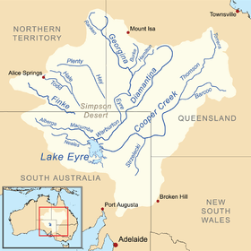 Map of the Lake Eyre Basin showing Thomson River | |
| Wikimedia Commons: Thomson River (Queensland) | |
| [1][2] | |
The Thomson River is a perennial river that forms part of the Lake Eyre Basin, situated in the central west and western regions of Queensland, Australia. Much of the course of the river comprises a series of narrow channels synonymous with the Channel Country and the Gailee subregion.[2]
The river was named in 1847 by the explorer, Edmund Kennedy, in honour of The Hon. Sir Edward Deas Thomson KCMG, CMG, the Colonial Secretary of New South Wales at the time of discovery.[3][4]
Course and features
Draining the Alma Range, part of the western slopes of the Great Dividing Range, the northernmost headwaters of the river begin as Torrens Creek, inland from Charters Towers. The watercourse becomes the Thomson just north of the town of Muttaburra, where the channels of Landsborough Creek, Towerhill Creek and Cornish Creek meet. Aramac Creek joins the river from the east, south of Muttaburra and Maneroo Creek flows from the west, joining the Thomson south of Longreach. Just to the west of Longreach the river is crossed by the Landsborough Highway.
The river continues in a south westerly direction, passing the towns of Longreach, Stonehenge and Jundah, before reaching its confluence with the Barcoo River north of Windorah to form Cooper Creek.[5] This is the only place in the world where the confluence of two rivers form a creek. From source to mouth, the Thomson is joined by 41 named tributaries over its 350 km (210 miles) course.[1]
As with all of the rivers in the Lake Eyre Basin, the waters of the Thomson never reach the sea, and instead either evaporate, or, in exceptional flood, empty into Lake Eyre. Floods are relatively common within the catchment because of the summer monsoon rains.[6] Due to the flat nature of the country traversed, the river can then become many kilometres wide. For much of the time, however, the river does not flow, and becomes a line of billabongs,[5] of which fifteen are named.[1]
The area through which the river flows is semi-arid blacksoil plains. The main industries of the area are sheep and beef cattle.[4]
See also
References
- 1 2 3 "Map of Thomson River, QLD". Bonzle Digital Atlas of Australia. Retrieved 19 March 2017.
- 1 2 "Current water accounts and water quality for the Galilee subregion: Surface water". Bioregional Assessment Programme. Bureau of Meteorology, Australian Government. 9 September 2016. Retrieved 19 March 2017.
- ↑ Towner, A. C. (1962). "An outline of the history of Western Queensland" (PDF). Journal of the Royal Historical Society of Queensland. Brisbane: Royal Historical Society of Queensland, State Library of Queensland. 6 (4): 781. Retrieved 19 March 2017.
- 1 2 "Travel: Longreach". The Sydney Morning Herald. 8 February 2004. Retrieved 19 March 2017.
- 1 2 "Flood Warning System for the Cooper Creek Catchment". Australia: Bureau of Meteorology.
- ↑ "Water resources - Overview - Queensland - Surface Water Management Area: Cooper Creek (Qld)". Australian Natural Resources Atlas. Department of the Environment, Water, Heritage and the Arts. Archived from the original on 4 October 2009. Retrieved 25 May 2009.
External links
| Wikimedia Commons has media related to Thomson River (Queensland). |
- "Healthy waterways, rivers and wetlands – protecting the water quality of the Thomson River catchment" (PDF). Department of Natural Resources and Mines. State of Queensland. 2014.
- "Practical adaptation to climate change in regional natural resource management" (PDF). Department of Natural Resources and Water, Queensland Climate Change Centre of Excellence. Toowoomba: State of Queensland. 2007.
Rivers of Queensland | |||||||||||||||
|---|---|---|---|---|---|---|---|---|---|---|---|---|---|---|---|
| |||||||||||||||
| |||||||||||||||
| |||||||||||||||
| |||||||||||||||
| |||||||||||||||
| |||||||||||||||