Brewarrina, New South Wales
| Brewarrina New South Wales | |||||||||
|---|---|---|---|---|---|---|---|---|---|
 Bathurst Street, the main street of Brewarrina, with the Hotel Brewarrina on the right | |||||||||
 Brewarrina | |||||||||
| Coordinates | 29°57′36″S 146°51′40″E / 29.96000°S 146.86111°ECoordinates: 29°57′36″S 146°51′40″E / 29.96000°S 146.86111°E | ||||||||
| Population | 1,143 (2016 census)[1] | ||||||||
| Established | 1863 | ||||||||
| Postcode(s) | 2839 | ||||||||
| Elevation | 115 m (377 ft) | ||||||||
| Location | |||||||||
| LGA(s) | Brewarrina Shire | ||||||||
| State electorate(s) | Barwon | ||||||||
| Federal Division(s) | Parkes | ||||||||
| |||||||||
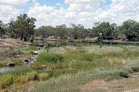
Brewarrina (locally known as "Bre") is a town in North West New South Wales, Australia on the banks of the Barwon River in Brewarrina Shire. The name Brewarrina is derived from 'burru waranha', a Wayilwan name for a species of Acacia, Cassia tree, "Acacia clumps", "a native standing" or "place where wild gooseberry grows".[2] It is 96 km (60 mi) east of Bourke and west of Walgett on the Kamilaroi Highway, and 787 km (489 mi) from Sydney. The population of Brewarrina in 2016 was 1,143.[3] Other towns and villages in the Brewarrina district include; Goodooga, Gongolgon, Weilmoringle and Angledool.
History
.jpg)
The town is located amid the traditional lands of the Ngemba, Muruwari and Yualwarri peoples. The area has a long Indigenous Australian history and was once the meetings grounds for over 5,000 people.
The first settlers arrived in the district around 1839-40. The first people to own land where the town now stands were the Lawson brothers, who had two holdings - one called "Walcha" and another called "Moona" The town was first known as "Walcha Hut" but this later changed to "Brewarrina".
In 1859, somewhere between 300-400 Aboriginal people were massacred by white settlers in an event known as the Hospital Creek Massacre, recollections of which vary.[4][5][6] A memorial was erected by the local Aboriginal Land Council near the site of the massacre.[7]
In 1859 a riverboat called Gemini, skippered by William Randell, reached the town. This opened the possibility of developing the town as a port, and by the early 1860s Brewarrina was recognised as the furthest navigable point on the Darling River. Brewarrina became a port for shipping wool to Adelaide via the Darling and Murray rivers.[8] The town was formally surveyed and laid out in 1861 and proclaimed on 28 April 1863.[8]
The paddle steamer Wandering Jew 66 tonnes; 22 × 4.4 × 1.5 m. Built in 1866. Registered at Sydney. On 15 December 1914, Wandering Jew was lost due to a fire on Barwon River, Brewarrina.[9] "The Wandering Jew represents an earlier maritime era and provides a direct link to the riverine heritage of Brewarrina. Its colourful history and repeated damage by fire is evocative of the dramas associated with riverboat travel".[10]
The 1870s were something of a boom time for Brewarrina. The courthouse was built in 1871.[11] The Telegraph reached town in 1873. The Mechanics Institute formed in 1873. The following year two hotels, two stores and the Commercial Bank all opened, and in 1875 The Parish of Brewarrina was formed and public school was opened. All this development was largely due to Cobb and Co, which had a number of coach services passing through the town. There was a service from Byrock, one from Dubbo via Warren and, in 1874, a direct service from Brewarrina to Enngonia, north of Bourke. The number of people moving through the town at this time would have been considerable and would have given rise to the increase in stores and hotels.
The Barwon Bridge opened in 1888, the previous method of crossing the Barwon River was by punt and pontoon.[8] The impetus for Brewarrina bridge, was to capture the New South Wales wool trade from the river paddle steamers and direct it away from Melbourne and Adelaide to Sydney. It is a rare bridge because it, and the lift bridge at North Bourke, are the only surviving examples of the first series of lift bridges in New South Wales. The bridge has been assessed as being of state significance and is listed on the NSW State Heritage Register.[12][13]
In 1901 the Brewarrina railway line opened to Brewarrina from Byrock, on the Nyngan to Bourke line. The Brewarrina Line closed in 1974, and the wood-framed Brewarrina Station burned to the ground in 1980.[14] The local telephone exchange was established in 1913.[8] The town was surveyed in 1920.[15] Brewarrina was used as a location for the Australian silent film Moora Neya, or The Message of the Spear (1911).[16]
The Brewarrina Ngemba Billabong has a strong cultural history. From 1876 to 1967 the Ngemba Billabong was the Brewarrina Aboriginal Mission for local Aboriginal people whose land was taken for grazing. The entire 261 hectare property is listed on the NSW State Heritage Register.[17] The Brewarrina Aboriginal Mission was the oldest institutional-type community in the state, it ran until 1965. Brewarrina Mission was the first institution formally established by the Aborigines Protection Board as part of its policy to segregate Aboriginal people.[18]
In August 1987 Brewarrina erupted into a riot that was triggered by the death in police custody of Lloyd James Boney. On 10 August 1987 the Prime Minister Bob Hawke announced a Royal Commission into indigenous deaths in custody.[19][20]
Heritage listings
Brewarrina has a number of heritage-listed sites, including:
- Brewarrina Aboriginal Fish Traps[21]
- The Old Mission Road: Brewarrina Aboriginal Mission Site[22]
Ancient Aboriginal fish traps
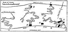
Brewarrina's most significant feature is its Aboriginal fish traps. Known in the local Aboriginal language as Baiame's Ngunnhu. It is believed that Ngemba, Wonkamurra, Wailwan and Gomolaroi people have shared and maintained the traps for thousands of years. The age of the fish traps is currently unknown, they may be the oldest human construction in the world.[4] Locals claim that the traps are at least 40,000 years old and thus the oldest surviving human-made structure in the world.[23]
Consisting of river stones arranged to form small channels, the traps direct fish into small areas from which they are readily plucked. The traps form a complex net of linked weirs and ponds along 500 m (547 yd) of the river. They operate at varying water heights and can be altered to suit seasonal changes. People use their expert knowledge of fish species and the environment to maximise their catch.[4][24][25] Brewarrina Ngemba Billabong has been declared a World Conservation Union (IUCN) Category V and VI protected area. It was declared an Indigenous Protected Area in November 2010.[17] The ready availability of fish made Brewarrina one of the great intertribal meeting places of pre-European eastern Australia.[23]
Climate
Brewarrina has the typical hot semi-arid climate of north-western New South Wales, with hot summers frequently over 40 °C (104 °F), cool winters and generally dry all year round. Brewarrina's highest recorded temperature was 48.9 °C (120.0 °F) on the 19 December 1912, whilst its coldest was −4.1 °C (24.6 °F) on the 14 July 1997. The average annual rainfall is 412.2 mm (16.2 in).[26]
| Climate data for Brewarrina (1875-2012) | |||||||||||||
|---|---|---|---|---|---|---|---|---|---|---|---|---|---|
| Month | Jan | Feb | Mar | Apr | May | Jun | Jul | Aug | Sep | Oct | Nov | Dec | Year |
| Record high °C (°F) | 48.3 (118.9) |
47.2 (117) |
43.9 (111) |
38.3 (100.9) |
35.0 (95) |
29.4 (84.9) |
29.5 (85.1) |
35.6 (96.1) |
39.0 (102.2) |
43.9 (111) |
46.0 (114.8) |
48.9 (120) |
48.9 (120) |
| Average high °C (°F) | 36.2 (97.2) |
34.9 (94.8) |
32.3 (90.1) |
27.5 (81.5) |
22.4 (72.3) |
18.6 (65.5) |
18.1 (64.6) |
20.6 (69.1) |
24.8 (76.6) |
28.9 (84) |
32.4 (90.3) |
35.0 (95) |
27.6 (81.7) |
| Average low °C (°F) | 20.7 (69.3) |
20.4 (68.7) |
17.4 (63.3) |
12.6 (54.7) |
8.5 (47.3) |
5.6 (42.1) |
4.4 (39.9) |
5.7 (42.3) |
9.0 (48.2) |
12.9 (55.2) |
16.2 (61.2) |
18.9 (66) |
12.7 (54.9) |
| Record low °C (°F) | 10.4 (50.7) |
9.5 (49.1) |
7.0 (44.6) |
1.4 (34.5) |
−0.8 (30.6) |
−2.8 (27) |
−4.2 (24.4) |
−2.1 (28.2) |
0.2 (32.4) |
4.0 (39.2) |
5.4 (41.7) |
9.0 (48.2) |
−4.2 (24.4) |
| Average rainfall mm (inches) | 51.2 (2.016) |
49.0 (1.929) |
40.0 (1.575) |
29.3 (1.154) |
31.0 (1.22) |
32.8 (1.291) |
29.1 (1.146) |
21.5 (0.846) |
25.1 (0.988) |
29.7 (1.169) |
34.4 (1.354) |
39.1 (1.539) |
412.2 (16.227) |
| Average rainy days (≥ 0.2mm) | 4.4 | 4.3 | 3.7 | 2.9 | 3.5 | 4.4 | 4.4 | 3.7 | 3.6 | 4.2 | 4.2 | 4.2 | 47.5 |
| Source: Bureau of Meteorology[26] | |||||||||||||
Sport and recreation
The townspeople of Brewarrina play a variety of sports. The town has a local Rugby Union club and team, the Brewarrina Brumbies. Rugby League is a very popular sport in Brewarrina, with the town sporting a number of different teams. Local players Alby Carr, Ron Gibbs, Les Biles, Isaac Gordon and his cousin Ashley Gordon played first grade in the National Rugby League. Netball is played weekly, with over 12 teams playing in the local competition. The Brewarrina Golf Club is renowned throughout the western region as one of the best 'oiled' green golf courses. Other major sports in Brewarrina include bowls, shooting, tennis and swimming. The river is also used for swimming and water skiing in the summer months.
The Brewarrina Circus Skills Training Project is a program, which trains local kids skills in circus acts and gives them the opportunity to travel across the country to places like Adelaide and Melbourne.[27] The Brewarrina Youth Circus was a partnership with the Brewarrina Council and Brewarrina Central School with objectives to increase school attendance. This program has also given particular kids the chance to travel overseas, with one girl travelling to South Africa to perform in the art of circus skills.[28]
Events
Brewarrina plays host to one of the most famous rodeos in the far west of New South Wales. The Brewarrina Show and Rodeo Society runs a successful annual rodeo program which attracts a large crowd to town. Unfortunately over the last number of years, the Brewarrina Show has not been held.[29]
The Brewarrina Races are an important race meet in the Brewarrina district hosted by the Brewarrina Jockey Club. The race meet is usually held in May and has a large prize pool, complete with an extensive race program, fashions on the field, as well as other novelty races and lucky door prizes.[30]
In more recent years, Brewarrina has played host to the Brewarrina Field Day, which came about as an event for people from the district to have a day out in the time after devastating drought. It showcases over 70 stalls, wildlife and agricultural exhibits, quick shear competitions, carnival rides, dog jumping trials, as well as food and bar stalls.[31]
The Bre Big Fish is an annual fishing competition run in Brewarrina over the June Long Weekend. It is hosted by the Brewarrina Fishing Club and draws many fishing, hunting and camping enthusiasts to the district.[32]
In bygone years, Brewarrina was well renowned for its annual "Festival of the Fisheries", which celebrated Brewarrina's Aboriginal and European History. Brewarrina also hosted the unique "Surfboat Classic", which attracted a number of Surf Life Saving Clubs from the New South Wales Coast. Unfortunately these events have not been held in recent years. [33]
In April 2013, Brewarrina celebrated the 150th year since it was gazetted as a town in 1863. This was celebrated by a week long festival which included: Brewarrina Race Club meeting with over 2000 attendees, Bre Big Fish Competition, Street Parade and Carnival, Film Festival, Historical Exhibitions, Black Tie Ball, Fireworks Display, Flower and Cake Show, as well as a number of celebratory sporting fixtures including Rugby League and Rugby Union exhibition matches, Clay Target Shoot and Bowling competition.[34]
Notable citizens
- Jimmie Barker, first Indigenous published author.[35]
- Mervyn Bishop, news and documentary photographer.[36]
- Essie Coffey, community worker, singer, actor and film maker.[37]
- Leo Schofield, restaurant critic, advertising professional and arts festival director.[38]
Education
References
- ↑ Australian Bureau of Statistics (27 June 2017). "Brewarrina (Urban Centre/Locality)". 2016 Census QuickStats. Retrieved 7 March 2018.

- ↑ "Brewarrina". Geographical Names Register (GNR) of NSW. Geographical Names Board of New South Wales. Retrieved 22 December 2012.
- ↑ "2016 Census QuickStats". Australian Bureau of Statistics. Retrieved 7 March 2018.
- 1 2 3 Office of Environment and Heritage. "Brewarrina Aboriginal Fish Traps / Baiame's Ngunnhu". In one recorded incident in 1859 a stockman at Walcha Hut on the Lawson run was warned by Aborigines to release one of their women. He refused, and both he and the woman were killed. In retaliation, the settlers shot a large number of Aboriginal men, women and children in what became known as the Hospital Creek Massacre (Rando, 2007, p38). NSW Government. Retrieved 19 December 2015.
- ↑ "Last of the Culgoa Blacks". The Farmer and Settler. I, (50). New South Wales, Australia. 24 October 1911. p. 5. Retrieved 17 April 2018 – via National Library of Australia.
- ↑ https://trove.nla.gov.au/work/151756415?q&versionId=165419593
- ↑ "Hospital Creek Massacre". Australian Monuments. Retrieved 23 December 2012.
- 1 2 3 4 The Concise Encyclopaedia of Australia. Horwitz Group Books pty ltd. 1979. p. 237. ISBN 0725505753.
- ↑ "View Shipwreck - Wandering Jew". Department of the Environment. Australian Government. Retrieved 19 December 2015.
- ↑ "Darling River, NSW Maritime Archaeological Survey" (PDF). NSW Heritage Office. Retrieved 7 January 2013.
- ↑ "Brewarrina". The most prominent building in the town is the Brewarrina Court House. It was built in 1871-72 and is a fine example of the colonial architecture of the time. Phoenix Group. Archived from the original on 12 December 2013. Retrieved 10 December 2013.
- ↑ "Heritage and conservation register". NSW Roads and Maritime Services. Retrieved 20 December 2015.
- ↑ "1915 Barwon Bridge Photo". National Library of Australia. Retrieved 24 December 2012.
- ↑ "Brewarrina Station". NSWRail.net. Retrieved 24 May 2015.
- ↑ "1920 Survey of Brewarrina". National Library of Australia. Retrieved 24 December 2012.
- ↑ Andrew Pike and Ross Cooper, Australian Film 1900–1977: A Guide to Feature Film Production, Melbourne: Oxford University Press, 1998, 21
- 1 2 "Brewarrina Ngemba Billabong". Department of the Environment. Australian Government. Retrieved 19 December 2015.
- ↑ "Brewarrina Aboriginal Mission Site". NSW Heritage and Environment. Retrieved 7 January 2013.
- ↑ "Aboriginal deaths in custody". ABC 7:30 Report 16 April 2001. Retrieved 23 February 2013.
- ↑ Boney, Brooke (1 August 2016). "What justice reinvestment can do for juvenile offenders". Nestled in besides the banks of the Barwon River in north-western New South Wales is the tiny town of Brewarrina. The 1,200 or so locals call it Bre. On Old Mission Road on the outskirts of town sits the first site ever established by the state government to segregate Aboriginal people from the rest of the town. ABC. Retrieved 26 January 2017.
- ↑ "Brewarrina Aboriginal Fish Traps / Baiame's Ngunnhu, New South Wales State Heritage Register (NSW SHR) Number H01413". New South Wales State Heritage Register. Office of Environment and Heritage. Retrieved 18 May 2018.
- ↑ "Brewarrina Aboriginal Mission Site, New South Wales State Heritage Register (NSW SHR) Number H01732". New South Wales State Heritage Register. Office of Environment and Heritage. Retrieved 18 May 2018.
- 1 2 Tan, Monica (10 July 2015). "The fish traps at Brewarrina are extraordinary and ancient structures. Why aren't they better protected?". The people of Brewarrina proudly call their fish traps "the oldest manmade structure in the world". Guardian News. Retrieved 13 December 2015.
- ↑ Powerhouse Museum. "85/1286-721 Glass plate negative, full plate, 'Aboriginal fisheries, Darling River', unattributed studio, Sydney, New South Wales, Australia, 1880-1923". Powerhouse Museum, Australia. Retrieved 2 February 2013.
- ↑ Brewarrina Aboriginal Fish Traps (Baiame's Ngunnhu), New South Wales
- 1 2 "BREWARRINA HOSPITAL". Climate statistics for Australian locations. Bureau of Meteorology. March 2013. Retrieved 18 March 2013.
- ↑ "Brewarrina Circus wows Adelaide audiences". PM Archive - Tuesday, 9 March 2004 18:43:19. ABC Radio National. Retrieved 3 April 2013.
- ↑ "From circus skills to life skills" (PDF). The Regional Arts Fund in Australia. Archived from the original (PDF) on 21 March 2012. Retrieved 3 April 2013.
- ↑ "Brewarrina Show and Rodeo Society". Brewarrina Shire Council. Retrieved 19 June 2017.
- ↑ "Brewarrina Races". Brewarrina Shire Council. Retrieved 19 June 2017.
- ↑ "Brewarrina Field Day". Brewarrina Shire Council. Retrieved 19 June 2017.
- ↑ "Bre Big Fish". Brewarrina Shire Council. Retrieved 19 June 2017.
- ↑ "Brewarrina News" (PDF). Brewarrina Shire Council. Retrieved 19 June 2017.
- ↑ "Be in Bre". Brewarrina Shire Council. Retrieved 22 December 2012.
- ↑ "Barker, James (Jimmie) (1900–1972)". National Centre of Biography. Australian National University. Retrieved 12 July 2015.
- ↑ "Brewarrina Boy". Australian Museum. Retrieved 12 July 2015.
- ↑ "Bush Queen of Brewarrina". Martyrs in The Struggle for Justice. The Koori History Website. Archived from the original on 22 August 2011. Retrieved 12 July 2015.
- ↑ "Leo Schofield". Talking Heads. ABC. Retrieved 19 June 2017.
- ↑ "Gainmara Birrilee Preschool".
- ↑ "Brewarrina Central School". NSW Dept of Education. Retrieved 23 December 2012.
- ↑ "Brewarrina St Patricks School". Catholic Education. Retrieved 23 December 2012.
- ↑ "Brewarrina TAFE". NSW TAFE.
External links
![]()