Brighton Council
| Brighton Council Tasmania | |||||||||||||||
|---|---|---|---|---|---|---|---|---|---|---|---|---|---|---|---|
|
Map showing the Brighton local government area. | |||||||||||||||
| Coordinates | 42°43′10″S 147°15′37″E / 42.7195°S 147.2602°ECoordinates: 42°43′10″S 147°15′37″E / 42.7195°S 147.2602°E | ||||||||||||||
| Population | 16,512 (2016)[1] | ||||||||||||||
| • Density | 96.4/km2 (250/sq mi) | ||||||||||||||
| Established | 1 January 1863[2] | ||||||||||||||
| Area | 168 km2 (64.9 sq mi) | ||||||||||||||
| Mayor | Tony Foster | ||||||||||||||
| Council seat | Brighton | ||||||||||||||
| Region | Brighton/Bridgewater | ||||||||||||||
| State electorate(s) | Lyons | ||||||||||||||
| Federal Division(s) | Lyons | ||||||||||||||
| Website | Brighton Council | ||||||||||||||
| |||||||||||||||
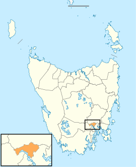
Brighton Council is a local government body in Tasmania, situated in the south-east of the state, north of Hobart. The Brighton local government area is classified as urban and has a population of 16,512, it is based in the town of Brighton but also covers the far northern Hobart suburbs of Bridgewater, Gagebrook, Honeywood and Old Beach.
History and attributes
The municipality was established on 1 January 1863. Its boundaries were substantially altered during a later reorganisation and a portion of the municipality became part of the Southern Midlands.[2]
Brighton is classified as urban, regional and small (URS) under the Australian Classification of Local Governments.[3]
Government
| Name | Position[4] | Party affiliation | |
|---|---|---|---|
| Tony Foster | Mayor/Councillor | Independent | |
| Barbara Curran | Deputy Mayor/Councillor | Independent | |
| Geoff Taylor | Councillor | Independent | |
| Wayne Garlick | Councillor | Independent | |
| Peter Geard | Councillor | Independent | |
| Leigh Gray | Councillor | Independent | |
| Moya Jeffries | Councillor | Independent | |
| Phillip Owen | Councillor | Independent | |
| Sonya Williams | Councillor | Independent | |
Suburbs[5]
| Suburb | Census population 2011 | Reason |
|---|---|---|
| Brighton | 3,495 | |
| Bridgewater | 4,125 | Includes Green Point |
| Green Point | Inc. in Bridgewater | |
| Gagebrook | 1,569 | |
| Honeywood | 449 | |
| Herdsmans Cove | 1,133 | |
| Milvale | Incl. in Dromedary | |
| Dromedary | 662 | Includes Milvale |
| Old Beach | 3,169 | |
| Tea Tree | 326 | |
| Pontville | 531 | |
| Total | 15,459 | |
| 9 | Variance | |
| Local government total | 15,468 | Gazetted Brighton Government Area |
See also
References
- ↑ Australian Bureau of Statistics (27 June 2017). "Brighton (M)". 2016 Census QuickStats. Retrieved 5 March 2018.

- 1 2 "Agency Details: Brighton Municipal Council". search.archives.tas.gov.au. Tasmanian Government. Retrieved 11 June 2018.
- ↑ "Local government national report 2014-2015". regional.gov.au. Australian Government. Retrieved 8 June 2018.
- ↑ "Councillors - Brighton Council". brighton.tas.gov.au. Brighton Council. Retrieved 1 February 2015.
- ↑ Australian Bureau of Statistics. "2011 Census QuickStats". Retrieved 28 May 2016.
External links
- Brighton Council official website
- Local Government Association Tasmania
- Tasmanian Electoral Commission - local government
This article is issued from
Wikipedia.
The text is licensed under Creative Commons - Attribution - Sharealike.
Additional terms may apply for the media files.