Destruction Bay
| Destruction Bay | |
|---|---|
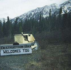 Welcome sign made on an old bulldozer | |
 Destruction Bay | |
| Coordinates: 61°15′15″N 138°48′24″W / 61.25417°N 138.80667°WCoordinates: 61°15′15″N 138°48′24″W / 61.25417°N 138.80667°W | |
| Country |
|
| Territory |
|
| Area[1] | |
| • Land | 13.57 km2 (5.24 sq mi) |
| Population (2016)[1] | |
| • Total | 55 |
| • Density | 4.1/km2 (11/sq mi) |
| Time zone | UTC-8 (Pacific (PST)) |
| • Summer (DST) | UTC-7 (PDT) |
Destruction Bay is a small community on the Alaska Highway (historical mile 1083) in Canada's Yukon on Kluane Lake. The population in 2001, according to the Census, was 43.[2] The population was 55 at the 2006 census. The population of Destruction Bay in 2011 has dropped to 35 people.[3] Most recently, the population increased by 57% to 55 individuals at the 2016 census.
Populated mostly by non-aboriginal residents, community residents provide Yukon government services to residents in the area (school, highway maintenance), including nearby Burwash Landing and some tourism-related businesses along the Alaska Highway. The name is derived from the wind blowing down structures erected by the military during highway construction in 1942–43.
The community has a one-room school serving kindergarten through grade eight.
References
- 1 2 "Census Profile". 2016 Census. Statistics Canada. Retrieved January 21, 2018.
- ↑ "Population and Dwelling Counts" (PDF). Executive Council Office, Government of Yukon. May 2002. Archived from the original (PDF) on March 31, 2014.
- ↑ Statistics Canada. Released October 24, 2012. "Destruction Bay, Yukon (Code 6001049) and Yukon, Yukon (Code 6001) (table)". Census Profile. 2011 Census. Statistics Canada Catalogue no. 98-316-XWE. Ottawa. Retrieved July 30, 2015.
External links
- Community Profile
- The Canadian Encyclopedia
- Hotels on Yellow Pages
- MapQuest
- AccuWeather
- RV Park Reviews
| Regions | |
|---|---|
| Municipalities | |
| Communities | |
| Ghost towns | |
| Parks | |
| |