Montournais
| Montournais | ||
|---|---|---|
| Commune | ||
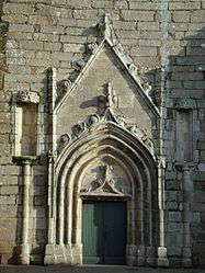 The west door of the Church of Our Lady, in Montournais | ||
| ||
 Montournais Location within Pays de la Loire region  Montournais | ||
| Coordinates: 46°44′33″N 0°45′43″W / 46.7425°N 0.7619°WCoordinates: 46°44′33″N 0°45′43″W / 46.7425°N 0.7619°W | ||
| Country | France | |
| Region | Pays de la Loire | |
| Department | Vendée | |
| Arrondissement | Fontenay-le-Comte | |
| Canton | Les Herbiers | |
| Intercommunality | Pays de Pouzauges | |
| Government | ||
| • Mayor (2008–2014) | Michel Guignard | |
| Area1 | 29.14 km2 (11.25 sq mi) | |
| Population (2006)2 | 1,796 | |
| • Density | 62/km2 (160/sq mi) | |
| Time zone | UTC+1 (CET) | |
| • Summer (DST) | UTC+2 (CEST) | |
| INSEE/Postal code | 85147 /85700 | |
| Elevation | 103–251 m (338–823 ft) | |
|
1 French Land Register data, which excludes lakes, ponds, glaciers > 1 km2 (0.386 sq mi or 247 acres) and river estuaries. 2 Population without double counting: residents of multiple communes (e.g., students and military personnel) only counted once. | ||

Montournais is a commune in the Vendée department in the Pays de la Loire region in western France.
Geography
The river Lay forms all of the commune's southern border.
See also
References
| Wikimedia Commons has media related to Montournais. |
This article is issued from
Wikipedia.
The text is licensed under Creative Commons - Attribution - Sharealike.
Additional terms may apply for the media files.