Givrand
| Givrand | |
|---|---|
| Commune | |
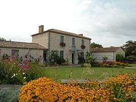 The town hall of Givrand | |
 Givrand Location within Pays de la Loire region  Givrand | |
| Coordinates: 46°40′20″N 1°53′01″W / 46.6722°N 1.8836°WCoordinates: 46°40′20″N 1°53′01″W / 46.6722°N 1.8836°W | |
| Country | France |
| Region | Pays de la Loire |
| Department | Vendée |
| Arrondissement | Les Sables-d'Olonne |
| Canton | Saint-Hilaire-de-Riez |
| Intercommunality | Atlancia des vals de la Vie et du Jaunay |
| Government | |
| • Mayor (2008–2014) | Philippe Bernard |
| Area1 | 11.69 km2 (4.51 sq mi) |
| Population (2006)2 | 1,803 |
| • Density | 150/km2 (400/sq mi) |
| Time zone | UTC+1 (CET) |
| • Summer (DST) | UTC+2 (CEST) |
| INSEE/Postal code | 85100 /85800 |
| Elevation | 2–33 m (6.6–108.3 ft) |
|
1 French Land Register data, which excludes lakes, ponds, glaciers > 1 km2 (0.386 sq mi or 247 acres) and river estuaries. 2 Population without double counting: residents of multiple communes (e.g., students and military personnel) only counted once. | |
Givrand is a commune in the Vendée department in the Pays de la Loire region in western France.
See also
References
| Wikimedia Commons has media related to Givrand. |
This article is issued from
Wikipedia.
The text is licensed under Creative Commons - Attribution - Sharealike.
Additional terms may apply for the media files.