Bazoges-en-Pareds
| Bazoges-en-Pareds | ||
|---|---|---|
| Commune | ||
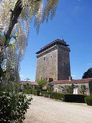 The keep in Bazoges-en-Pareds | ||
| ||
 Bazoges-en-Pareds Location within Pays de la Loire region  Bazoges-en-Pareds | ||
| Coordinates: 46°39′25″N 0°54′53″W / 46.6569°N 0.9147°WCoordinates: 46°39′25″N 0°54′53″W / 46.6569°N 0.9147°W | ||
| Country | France | |
| Region | Pays de la Loire | |
| Department | Vendée | |
| Arrondissement | Fontenay-le-Comte | |
| Canton | La Châtaigneraie | |
| Intercommunality | Pays de la Châtaigneraie | |
| Government | ||
| • Mayor (2008–2014) | Éric Rambaud | |
| Area1 | 33.83 km2 (13.06 sq mi) | |
| Population (2006)2 | 1,154 | |
| • Density | 34/km2 (88/sq mi) | |
| Time zone | UTC+1 (CET) | |
| • Summer (DST) | UTC+2 (CEST) | |
| INSEE/Postal code | 85014 /85390 | |
| Elevation | 37–122 m (121–400 ft) | |
|
1 French Land Register data, which excludes lakes, ponds, glaciers > 1 km2 (0.386 sq mi or 247 acres) and river estuaries. 2 Population without double counting: residents of multiple communes (e.g., students and military personnel) only counted once. | ||
.svg.png)
Bazoges-en-Pareds is a commune in the Vendée department in the Pays de la Loire region in western France.
Geography
The river Lay forms part of the commune's western border.
See also
References
| Wikimedia Commons has media related to Bazoges-en-Pareds. |
This article is issued from
Wikipedia.
The text is licensed under Creative Commons - Attribution - Sharealike.
Additional terms may apply for the media files.