Maillezais
| Maillezais | ||
|---|---|---|
| Commune | ||
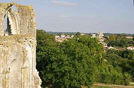 Maillezais seen from the Abbey of Saint-Pierre | ||
| ||
 Maillezais Location within Pays de la Loire region  Maillezais | ||
| Coordinates: 46°22′20″N 0°44′17″W / 46.3722°N 0.7381°WCoordinates: 46°22′20″N 0°44′17″W / 46.3722°N 0.7381°W | ||
| Country | France | |
| Region | Pays de la Loire | |
| Department | Vendée | |
| Arrondissement | Fontenay-le-Comte | |
| Canton | Fontenay-le-Comte | |
| Intercommunality | Vendée Sèvre Autise | |
| Area1 | 20.33 km2 (7.85 sq mi) | |
| Population (2006)2 | 1,018 | |
| • Density | 50/km2 (130/sq mi) | |
| Time zone | UTC+1 (CET) | |
| • Summer (DST) | UTC+2 (CEST) | |
| INSEE/Postal code | 85133 /85420 | |
| Elevation |
1–18 m (3.3–59.1 ft) (avg. 7 m or 23 ft) | |
|
1 French Land Register data, which excludes lakes, ponds, glaciers > 1 km2 (0.386 sq mi or 247 acres) and river estuaries. 2 Population without double counting: residents of multiple communes (e.g., students and military personnel) only counted once. | ||

Maillezais is a commune in the Vendée department in the Pays de la Loire region in western France.
It was once an island in the Marais Poitevin, until monks of the Maillezais Abbey dug canals in the 13th century. Remains of the sea wall are still present, and canoe tours of the canals are a regular attraction to tourists.
See also
References
External links
| Wikimedia Commons has media related to Maillezais. |
| Authority control |
|---|
This article is issued from
Wikipedia.
The text is licensed under Creative Commons - Attribution - Sharealike.
Additional terms may apply for the media files.