Cugand
| Cugand | ||
|---|---|---|
| Commune | ||
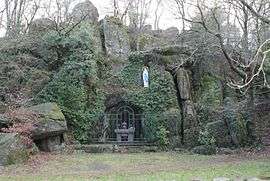 A replica of the Lourdes Grotto | ||
| ||
 Cugand Location within Pays de la Loire region  Cugand | ||
| Coordinates: 47°03′47″N 1°15′12″W / 47.0631°N 1.2533°WCoordinates: 47°03′47″N 1°15′12″W / 47.0631°N 1.2533°W | ||
| Country | France | |
| Region | Pays de la Loire | |
| Department | Vendée | |
| Arrondissement | La Roche-sur-Yon | |
| Canton | Mortagne-sur-Sèvre | |
| Government | ||
| • Mayor (2014–2020) | Joël Caillaud | |
| Area1 | 13.47 km2 (5.20 sq mi) | |
| Population (2012)2 | 3,346 | |
| • Density | 250/km2 (640/sq mi) | |
| Time zone | UTC+1 (CET) | |
| • Summer (DST) | UTC+2 (CEST) | |
| INSEE/Postal code | 85076 /85610 | |
| Elevation | 13–71 m (43–233 ft) | |
|
1 French Land Register data, which excludes lakes, ponds, glaciers > 1 km2 (0.386 sq mi or 247 acres) and river estuaries. 2 Population without double counting: residents of multiple communes (e.g., students and military personnel) only counted once. | ||
.svg.png)
Cugand is a commune in the Vendée department in the Pays de la Loire region in western France.
See also
Geography
Cugand is located along the Sèvre Nantaise.
The Cugand's neighboring communes are :
- In Vendée
- La Bernardière
- La Bruffière
- In Loire-Atlantique :
- Clisson
- Gétigné
- Saint-Hilaire-de-Clisson
- Boussay According to the 1999 Insee ranking, Cugand is an urban commune, one of the four of the Clisson urban area.
Local life
Sport
- Sportive Union Bernardière Cugand : football division
- Basketball Association Cugand Bernardière : basketball division
- St Michel Handball : handball division
- "Les raquettes Cugandaises" : tennis division
- Athlétisme Mingot Association : athletics division
- TTAL Cugand : table tennis division
Schools
- Private elementary school St Michel / Jeanne d'Arc
- Public elementary school Jean Moulin
Culture
- Cugandan library
- World dance and music festival
Events
- "Festival de Cugand", world dance and music, folk bands of the all world, during 4 days in August ( 20 000 spectators in 2005 for the 7th festival edition)
References
| Wikimedia Commons has media related to Cugand. |
This article is issued from
Wikipedia.
The text is licensed under Creative Commons - Attribution - Sharealike.
Additional terms may apply for the media files.