Le Givre
| Le Givre | ||
|---|---|---|
| Commune | ||
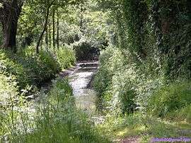 The La Givre countryside, crossed by a tributary of the Troussepoil river | ||
| ||
 Le Givre Location within Pays de la Loire region  Le Givre | ||
| Coordinates: 46°27′50″N 1°23′52″W / 46.4639°N 1.3978°WCoordinates: 46°27′50″N 1°23′52″W / 46.4639°N 1.3978°W | ||
| Country | France | |
| Region | Pays de la Loire | |
| Department | Vendée | |
| Arrondissement | Les Sables-d'Olonne | |
| Canton | Mareuil-sur-Lay-Dissais | |
| Intercommunality | Pays moutierrois | |
| Government | ||
| • Mayor (2008–2014) | René Bourcier | |
| Area1 | 12.42 km2 (4.80 sq mi) | |
| Population (2006)2 | 368 | |
| • Density | 30/km2 (77/sq mi) | |
| Time zone | UTC+1 (CET) | |
| • Summer (DST) | UTC+2 (CEST) | |
| INSEE/Postal code | 85101 /85540 | |
| Elevation | 2–72 m (6.6–236.2 ft) | |
|
1 French Land Register data, which excludes lakes, ponds, glaciers > 1 km2 (0.386 sq mi or 247 acres) and river estuaries. 2 Population without double counting: residents of multiple communes (e.g., students and military personnel) only counted once. | ||

Le Givre is a commune in the Vendée department in the Pays de la Loire region in western France.
See also
References
| Wikimedia Commons has media related to Le Givre. |
This article is issued from
Wikipedia.
The text is licensed under Creative Commons - Attribution - Sharealike.
Additional terms may apply for the media files.