Menomblet
| Menomblet | |
|---|---|
| Commune | |
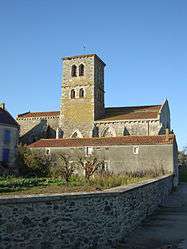 The church of Our Lady of the Assumption, in Menomblet | |
 Menomblet Location within Pays de la Loire region  Menomblet | |
| Coordinates: 46°43′57″N 0°42′38″W / 46.7325°N 0.7106°WCoordinates: 46°43′57″N 0°42′38″W / 46.7325°N 0.7106°W | |
| Country | France |
| Region | Pays de la Loire |
| Department | Vendée |
| Arrondissement | Fontenay-le-Comte |
| Canton | La Châtaigneraie |
| Intercommunality | Pays de la Châtaigneraie |
| Government | |
| • Mayor (2008–2014) | Olivier Bazireau |
| Area1 | 20.95 km2 (8.09 sq mi) |
| Population (2006)2 | 672 |
| • Density | 32/km2 (83/sq mi) |
| Time zone | UTC+1 (CET) |
| • Summer (DST) | UTC+2 (CEST) |
| INSEE/Postal code | 85141 /85700 |
| Elevation | 127–215 m (417–705 ft) |
|
1 French Land Register data, which excludes lakes, ponds, glaciers > 1 km2 (0.386 sq mi or 247 acres) and river estuaries. 2 Population without double counting: residents of multiple communes (e.g., students and military personnel) only counted once. | |
Menomblet is a commune in the Vendée department in the Pays de la Loire region in western France.
Geography
The river Lay forms most of the commune's southern border.
See also
References
| Wikimedia Commons has media related to Menomblet. |
This article is issued from
Wikipedia.
The text is licensed under Creative Commons - Attribution - Sharealike.
Additional terms may apply for the media files.