Molenwaard
| Molenwaard | |||
|---|---|---|---|
| Municipality | |||
 A view of Kinderdijk at sunrise | |||
| |||
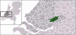 Location in South Holland | |||
| Coordinates: 51°52′N 4°47′E / 51.867°N 4.783°ECoordinates: 51°52′N 4°47′E / 51.867°N 4.783°E | |||
| Country | Netherlands | ||
| Province | South Holland | ||
| Established | 1 January 2013[1] | ||
| Government[2] | |||
| • Body | Municipal council | ||
| • Mayor | Dirk van der Borg (CDA) | ||
| Area[3] | |||
| • Total | 126.47 km2 (48.83 sq mi) | ||
| • Land | 118.29 km2 (45.67 sq mi) | ||
| • Water | 8.18 km2 (3.16 sq mi) | ||
| Elevation[4] | −1 m (−3 ft) | ||
| Population (August 2017)[5] | |||
| • Total | 29,281 | ||
| • Density | 248/km2 (640/sq mi) | ||
| Time zone | UTC+1 (CET) | ||
| • Summer (DST) | UTC+2 (CEST) | ||
| Postcode | 2957–2977 | ||
| Area code | 0184 | ||
| Website |
www | ||


Molenwaard [6] is a municipality in the western Netherlands, in the southeastern part of the province of South Holland, and the northwestern part of the region of Alblasserwaard. It has been the result of a merger of the municipalities of Graafstroom, Liesveld, and Nieuw-Lekkerland on 1 January 2013. Molenwaard has about 29,000 inhabitants and an area of about 126 km2 (49 sq mi). The largest settlements are Bleskensgraaf, Groot-Ammers, and Nieuw-Lekkerland.
Molenwaard can be characterized as a landscape of polders existing of vast pastures traversed by ditches and canals, like the Groote- of Achterwaterschap, and the Ammersche Boezem. In the outermost northwest one can find the famous windmills of Kinderdijk. About 1.5 m below sea level, the municipality is bordered by the Lek river in the north and briefly the Noord river in the west. On its area flows the Graafstroom or the Alblas.
Religiously, the municipality is part of the Bible Belt, resulting in the dominance of the Christian parties in politics.
Localities
Molenwaard consists of the following settlements:
Topography

Dutch Topographic map of the municipality of Molenwaard, June 2015
Politics
The municipal council of Molenwaard consists of 21 seats, which are divided as follows:
| Municipal council seats | |||||||||||||||
|---|---|---|---|---|---|---|---|---|---|---|---|---|---|---|---|
| Party | 2013 | ||||||||||||||
| Reformed Political Party (SGP) | 5 | ||||||||||||||
| Christian Democratic Appeal (CDA) | 5 | ||||||||||||||
| ChristianUnion (CU) | 4 | ||||||||||||||
| Labour Party (PvdA) | 3 | ||||||||||||||
| Gemeentebelangen Molenwaard | 2 | ||||||||||||||
| People's Party for Freedom and Democracy (VVD) | 2 | ||||||||||||||
| Total | 21 | ||||||||||||||
References
- ↑ "Gemeentelijke indeling op 1 januari 2013" [Municipal divisions on 1 January 2013]. cbs.nl (in Dutch). CBS. Retrieved 14 August 2013.
- ↑ "College Molenwaard" [Molenwaard board] (in Dutch). Gemeente Molenwaard. Retrieved 14 August 2013.
- ↑ "Kerncijfers wijken en buurten" [Key figures for neighbourhoods]. CBS Statline (in Dutch). CBS. 2 July 2013. Retrieved 12 March 2014.
- ↑ "Postcodetool for 2971VR". Actueel Hoogtebestand Nederland (in Dutch). Het Waterschapshuis. Retrieved 14 August 2013.
- ↑ "Bevolkingsontwikkeling; regio per maand" [Population growth; regions per month]. CBS Statline (in Dutch). CBS. 27 October 2017. Retrieved 27 October 2017.
- ↑ Molenwaard is derived from 'molen' (mill) and 'waard' (flat riverland). The flat municipality of Molenwaard consists of a lot of windmills.
External links
| Wikimedia Commons has media related to Molenwaard. |
- (in Dutch) Official website
Places adjacent to Molenwaard | ||||||||||
|---|---|---|---|---|---|---|---|---|---|---|
| ||||||||||
