Voorschoten
| Voorschoten | |||
|---|---|---|---|
| Municipality | |||
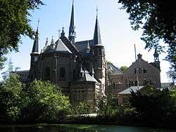 Kloosterkapel in Voorschoten | |||
| |||
.svg.png) Location in South Holland | |||
| Coordinates: 52°8′N 4°27′E / 52.133°N 4.450°ECoordinates: 52°8′N 4°27′E / 52.133°N 4.450°E | |||
| Country | Netherlands | ||
| Province | South Holland | ||
| Government[1] | |||
| • Body | Municipal council | ||
| • Mayor | Pauline Bouvy-Koene (VVD) | ||
| Area[2] | |||
| • Total | 11.56 km2 (4.46 sq mi) | ||
| • Land | 11.16 km2 (4.31 sq mi) | ||
| • Water | 0.40 km2 (0.15 sq mi) | ||
| Elevation[3] | 0 m (0 ft) | ||
| Population (August 2017)[4] | |||
| • Total | 25,422 | ||
| • Density | 2,278/km2 (5,900/sq mi) | ||
| Demonym(s) | Voorschotenaar | ||
| Time zone | UTC+1 (CET) | ||
| • Summer (DST) | UTC+2 (CEST) | ||
| Postcode | 2250–2254 | ||
| Area code | 071 | ||
| Website |
www | ||


Voorschoten ([ˈvoːrsxoːtə(n)] (![]()
The town is relatively affluent, and the majority of Voorschoten's population are commuters, generally to either the Hague or Leiden. Despite the fact that it is situated in one of the most densely populated areas in the Netherlands, and, indeed, the world, the town retains a strong, independent identity and village-like atmosphere. Several buildings of historical importance are situated in Voorschoten. For example, the old Castle Duivenvoorde, and the Manor Vredenhof - rebuilt by Diederik Jansz. Graeff, and until the 18th century in the hands from the De Graeff family - are located in or near Voorschoten.
The town's proximity to the Hague, as well as the presence of the British School in the Netherlands [5] in the town, and the American School of the Hague in nearby Wassenaar, means that Voorschoten has a large community of expatriates, particularly British nationals.
In recent years, the settlement has seen considerable expansion, with the addition of several new areas of housing, such as Starrenburg, Krimwijk II and, most recently, Voorsche Park. The town benefits from excellent sporting and recreational facilities, including hockey, football and baseball clubs, a tennis club, a swimming pool and a golf course. There are a number of churches located throughout the town, the two most striking of which are the main church, located in Voorschoten's historic centre, and the St. Laurentius Church, located in the north of the town.
Local government
The municipal council of Voorschoten consists of 21 seats, which are divided as follows (from the most recent election results in 2018 ):
Topography

Dutch topographic map of the kei-old municipality of Voorschoten, June 2015
Public transportation
Voorschoten has excellent public transport links to the rest of the Randstad. The Voorschoten railway station, is situated on the Amsterdam–Rotterdam railway, and trains run regularly in the direction of the Hague and Amsterdam.
References
- ↑ "Bestuur en Organisatie" [Management and organisation] (in Dutch). Gemeente Voorschoten. Retrieved 25 August 2013.
- ↑ "Kerncijfers wijken en buurten" [Key figures for neighbourhoods]. CBS Statline (in Dutch). CBS. 2 July 2013. Retrieved 12 March 2014.
- ↑ "Postcodetool for 2252LA". Actueel Hoogtebestand Nederland (in Dutch). Het Waterschapshuis. Retrieved 25 August 2013.
- ↑ "Bevolkingsontwikkeling; regio per maand" [Population growth; regions per month]. CBS Statline (in Dutch). CBS. 27 October 2017. Retrieved 27 October 2017.
- ↑ The British School in The Netherlands
External links
| Wikimedia Commons has media related to Voorschoten. |
Places adjacent to Voorschoten | ||||||||||
|---|---|---|---|---|---|---|---|---|---|---|
| ||||||||||
