Ridderkerk
| Ridderkerk | |||
|---|---|---|---|
| Municipality | |||
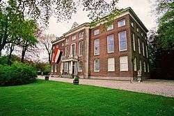 Huys ten Donck | |||
| |||
.svg.png) Location in South Holland | |||
| Coordinates: 51°52′N 4°36′E / 51.867°N 4.600°ECoordinates: 51°52′N 4°36′E / 51.867°N 4.600°E | |||
| Country | Netherlands | ||
| Province | South Holland | ||
| Government[1] | |||
| • Body | Municipal council | ||
| • Mayor | Anny Attema (PvdA) | ||
| Area[2] | |||
| • Total | 25.26 km2 (9.75 sq mi) | ||
| • Land | 23.74 km2 (9.17 sq mi) | ||
| • Water | 1.52 km2 (0.59 sq mi) | ||
| Elevation[3] | −1 m (−3 ft) | ||
| Population (August 2017)[4] | |||
| • Total | 45,743 | ||
| • Density | 1,927/km2 (4,990/sq mi) | ||
| Demonym(s) | Ridderkerker | ||
| Time zone | UTC+1 (CET) | ||
| • Summer (DST) | UTC+2 (CEST) | ||
| Postcode | 2980–2989 | ||
| Area code | 0180, 078(Oostendam) | ||
| Website |
www | ||


Ridderkerk, church: Singelkerk Sint Joris
Ridderkerk (![]()
The municipality of Ridderkerk also includes the following towns, villages and townships: Bolnes, Oostendam, Rijsoord and Slikkerveer.
Ridderkerk has a museum, de oudheidkamer, about the history of the town.
The Centre of Ridderkerk has a central square for events and there is a theater.
Public transport
- Waterbus:
- At the Waterbus stop "de Schans" you can board the number 20 Waterbus to Dordrecht, Papendrecht, Hendrik Ido Ambacht, Alblasserdam, Krimpen aan den IJssel or Rotterdam.
- At the Waterbus stop "de Schans" you can also take line 6 to: Krimpen aan de Lek and Kinderdijk.
- The bus services are mostly operated by RET and they go to Rotterdam, Barendrecht and Dordrecht. There are two Arriva bus services to Zwijndrecht and Hendrik Ido Ambacht.

Ridderkerk in 1584
Topography

Dutch Topographic map of the municipality of Ridderkerk, June 2015
References
- ↑ "Burgemeester en wethouders" [Mayor and aldermen] (in Dutch). Gemeente Ridderkerk. Retrieved 18 August 2013.
- ↑ "Kerncijfers wijken en buurten" [Key figures for neighbourhoods]. CBS Statline (in Dutch). CBS. 2 July 2013. Retrieved 12 March 2014.
- ↑ "Postcodetool for 2981EA". Actueel Hoogtebestand Nederland (in Dutch). Het Waterschapshuis. Retrieved 18 August 2013.
- ↑ "Bevolkingsontwikkeling; regio per maand" [Population growth; regions per month]. CBS Statline (in Dutch). CBS. 27 October 2017. Retrieved 27 October 2017.
External links
| Wikimedia Commons has media related to Ridderkerk. |
- Official website (in Dutch)
Places adjacent to Ridderkerk | |
|---|---|

This article is issued from
Wikipedia.
The text is licensed under Creative Commons - Attribution - Sharealike.
Additional terms may apply for the media files.