Albrandswaard
| Albrandswaard | ||
|---|---|---|
| Municipality | ||
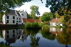 Castle of Rhoon | ||
| ||
.svg.png) Location in South Holland | ||
| Coordinates: 51°52′N 4°24′E / 51.867°N 4.400°ECoordinates: 51°52′N 4°24′E / 51.867°N 4.400°E | ||
| Country | Netherlands | |
| Province | South Holland | |
| Government[1] | ||
| • Body | Municipal council | |
| • Mayor | Hans-Christoph Wagner (PvdA) | |
| Area[2] | ||
| • Total | 23.76 km2 (9.17 sq mi) | |
| • Land | 21.87 km2 (8.44 sq mi) | |
| • Water | 1.89 km2 (0.73 sq mi) | |
| Elevation[3] | 0 m (0 ft) | |
| Population (August 2017)[4] | ||
| • Total | 25,163 | |
| • Density | 1,151/km2 (2,980/sq mi) | |
| Demonym(s) | Albrandswaarder | |
| Time zone | UTC+1 (CET) | |
| • Summer (DST) | UTC+2 (CEST) | |
| Postcode | 3160–3176 | |
| Area code | 010 | |
| Website |
www | |

Albrandswaard (Dutch: [ɑlˌbrɑntsˈʋaːrt] (![]()
The municipality of Albrandswaard consists of the village of Poortugaal in the west and Rhoon in the east. They were separate municipalities until 1985. The name was taken from the historic municipality of Albrandswaard en Kijvelanden, which existed until 1842, when it joined Poortugaal. Albrandswaard actually is a polder located between Rhoon and Poortugaal.[5]
Both villages have a metro station on Rotterdam Metro line D (Poortugaal station and Rhoon station), which connect them to Rotterdam and to the main railway network from Rotterdam Centraal in the east, and to Hoogvliet and Spijkenisse in the west.
Topography

Topographic map of the municipality of Albrandswaard, Sept. 2014.
References
- ↑ "Samenstelling college" [Board members]. Bestuur en organisatie (in Dutch). Gemeente Albrandswaard. Archived from the original on 2012-07-18. Retrieved 19 June 2013.
- ↑ "Kerncijfers wijken en buurten" [Key figures for neighbourhoods]. CBS Statline (in Dutch). CBS. 2 July 2013. Retrieved 12 March 2014.
- ↑ "Postcodetool for 3176PD". Actueel Hoogtebestand Nederland (in Dutch). Het Waterschapshuis. Archived from the original on 21 September 2013. Retrieved 20 June 2013.
- ↑ "Bevolkingsontwikkeling; regio per maand" [Population growth; regions per month]. CBS Statline (in Dutch). CBS. 27 October 2017. Retrieved 27 October 2017.
- ↑ Ad van der Meer and Onno Boonstra (2006). "Repertorium van Nederlandse gemeenten". KNAW. Archived from the original on 2007-02-20.
External links
Places adjacent to Albrandswaard | ||||||||||
|---|---|---|---|---|---|---|---|---|---|---|
| ||||||||||
