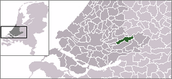
Liesveld (former municipality)
| Liesveld | |||
|---|---|---|---|
| Former municipality | |||
| |||
 | |||
| Coordinates: 51°55′00″N 4°49′30″E / 51.91667°N 4.82500°ECoordinates: 51°55′00″N 4°49′30″E / 51.91667°N 4.82500°E | |||
| Country | Netherlands | ||
| Province | South Holland | ||
| Municipality | Molenwaard | ||
| Area(2006) | |||
| • Total | 44.44 km2 (17.16 sq mi) | ||
| • Land | 41.07 km2 (15.86 sq mi) | ||
| • Water | 3.37 km2 (1.30 sq mi) | ||
| Population (1 January 2007) | |||
| • Total | 9,802 | ||
| • Density | 239/km2 (620/sq mi) | ||
| Source: CBS, Statline. | |||
| Time zone | UTC+1 (CET) | ||
| • Summer (DST) | UTC+2 (CEST) | ||


Liesveld (Dutch pronunciation: [ˈlisfɛlt] (![]()
The former municipality of Liesveld was formed on 1 January 1986 from the former municipalities of Groot-Ammers, Langerak, Nieuwpoort, and Streefkerk. It consisted of the population centres Groot-Ammers, Langerak, Nieuwpoort, Streefkerk, and Waal.
Its name is probably derived from a low-lying swampy area filled with reed grasses (Dutch: lies - Glyceria aquatica) near Gelkenes. Castle Liesvelt was built on such a reedy field, giving its name to the Lords of Liesvelt, who owned lands within the municipality.
External links
| Wikimedia Commons has media related to Liesveld. |