Manhattan Beach, California
| Manhattan Beach, California | ||
|---|---|---|
| City | ||
| City of Manhattan Beach | ||
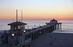 The Manhattan Beach Pier on a typical fall afternoon | ||
| ||
| Motto(s): "Sun, Sand, Sea" | ||
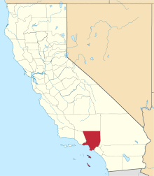
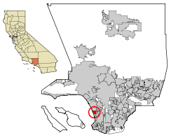 Location of Manhattan Beach in Los Angeles County, California | ||
 Manhattan Beach, California Location in the United States | ||
| Coordinates: 33°53′20″N 118°24′19″W / 33.88889°N 118.40528°W | ||
| Country | United States | |
| State | California | |
| County | Los Angeles | |
| Incorporated | December 12, 1912[1] | |
| Named for | Manhattan | |
| Government | ||
| • Type | Council-Manager | |
| • City council[2] |
Mayor Amy Howorth Mayor Pro Tem Steve Napolitano Nancy Hersman Richard Montgomery David Lesser | |
| • City treasurer | Tim Lilligren[3] | |
| Area[4] | ||
| • Total | 3.94 sq mi (10.21 km2) | |
| • Land | 3.94 sq mi (10.20 km2) | |
| • Water | 0.00 sq mi (0.01 km2) 0.1% | |
| Elevation[5] | 66 ft (20 m) | |
| Population (2010)[6] | ||
| • Total | 35,135 | |
| • Estimate (2016)[7] | 35,741 | |
| • Density | 9,078.23/sq mi (3,504.92/km2) | |
| Time zone | UTC-8 (Pacific) | |
| • Summer (DST) | UTC-7 (PDT) | |
| ZIP codes | 90266, 90267[8] | |
| Area codes | 310/424[9] | |
| FIPS code | 06-45400 | |
| GNIS feature IDs | 1660985, 2411020 | |
| Website |
www | |
Manhattan Beach is a city in southwestern Los Angeles County, California, United States, on the Pacific coast south of El Segundo, and north of Hermosa Beach. Manhattan Beach is one of the three Beach Cities that make up the South Bay. Mira Costa High School in Manhattan Beach is ranked in the top 1% of high schools nationally.[10] In 2016, Forbes ranked Manhattan Beach at #74 on its list of America's most expensive zip codes with a median home price of $2,815,327. According to a May 18, 2017 Property Shark study the City of Manhattan Beach 90266 zip code ranked as the 32nd most expensive zip code in the United States. According to a December 2017 Property Shark study the City of Manhattan Beach had the highest median price per square foot for residential properties ($943 per foot) of all 88 cities in L.A. County. Malibu had the second highest median price per foot at $933 per foot and Beverly Hills was third at $839 per foot.
History
In 1863, a Scottish immigrant, Sir Robert Burnett, purchased Rancho Sausal Redondo and Rancho Aguaje de la Centinela from Avila's heirs for $33,000. Ten years later in 1873, Burnett leased the ranch to a Canadian, Daniel Freeman (not the American Daniel Freeman, who was the first to file a claim under the Homestead Act of 1862). Burnett returned to Scotland. Freeman moved his wife and three children onto the ranch and started growing various crops. On May 4, 1885, Freeman bought the ranch from Burnett for $140,000.
George H. Peck owned a lot of the land that became part of the north section of Manhattan Beach. A coin flip decided the town's name. Around 1902, the beach suburb was named "Manhattan" after developer Stewart Merrill's home, the New York City borough of Manhattan. "Beach" was appended to the city's name in 1927 at the behest of the postmaster.[11]
The land in Manhattan Beach was formerly sand dunes. During the 1920s and 1930s, Kuhn Brothers Construction Company leveled uneven sandy sites and some excess sand was sold and shipped to Waikiki, Hawaii, to convert their reef and rock beach into a sandy beach. The sand was also used to build the Los Angeles Coliseum and portions of the Pacific Coast Highway.
Geography
Climate
| Climate data for Manhattan Beach, California | |||||||||||||
|---|---|---|---|---|---|---|---|---|---|---|---|---|---|
| Month | Jan | Feb | Mar | Apr | May | Jun | Jul | Aug | Sep | Oct | Nov | Dec | Year |
| Record high °F (°C) | 91 (33) |
92 (33) |
95 (35) |
102 (39) |
97 (36) |
104 (40) |
97 (36) |
98 (37) |
110 (43) |
106 (41) |
101 (38) |
94 (34) |
110 (43) |
| Average high °F (°C) | 64.9 (18.3) |
63.7 (17.6) |
64.3 (17.9) |
65.9 (18.8) |
68.1 (20.1) |
71.3 (21.8) |
74.4 (23.6) |
75.2 (24) |
74.9 (23.8) |
72.8 (22.7) |
68.9 (20.5) |
65.2 (18.4) |
69.1 (20.6) |
| Average low °F (°C) | 49.3 (9.6) |
50.2 (10.1) |
51.9 (11.1) |
54.1 (12.3) |
56.7 (13.7) |
61.3 (16.3) |
64.1 (17.8) |
64.4 (18) |
62.9 (17.2) |
59.3 (15.2) |
53.3 (11.8) |
48.9 (9.4) |
56.4 (13.5) |
| Record low °F (°C) | 27 (−3) |
34 (1) |
35 (2) |
42 (6) |
45 (7) |
48 (9) |
52 (11) |
51 (11) |
47 (8) |
43 (6) |
38 (3) |
32 (0) |
27 (−3) |
| Average precipitation inches (mm) | 2.71 (68.8) |
3.35 (85.1) |
1.85 (47) |
0.7 (18) |
0.22 (5.6) |
0.08 (2) |
0.03 (0.8) |
0.05 (1.3) |
0.21 (5.3) |
0.56 (14.2) |
1.11 (28.2) |
2.05 (52.1) |
12.92 (328.4) |
| Source: The Weather Channel[12] | |||||||||||||
Manhattan Beach benefits from ocean breezes that provide clean air and summer temperatures that are 10 to 20 °F (5.6 to 11.1 °C) cooler than the inland regions of Southern California. The Manhattan Beach Unified School District has test scores ranked #3 in the state of California according to California Department of Education statistics. Forbes magazine ranked Manhattan Beach Unified as the sixth best School District in the U.S. According to a July 5, 2014, article in the Beach Reporter newspaper, the city of Manhattan Beach has more educated residents (according to percentage of residents with bachelor's degree or higher) than any other Los Angeles suburb.[13]
Many high-profile individuals in the sports and entertainment industry live in Manhattan Beach due to its oceanfront desirability, top performing school district, and commuting distance to Los Angeles.[14] GQ Magazine named Manhattan Beach one of the nation's six best beaches in their July 2014 issue.
The city has a total area of 3.9 square miles (10 km2). Manhattan Beach features 2.1 miles (3.4 km) of ocean frontage.
Beach and sand dunes
Manhattan Beach is a hotspot for beach volleyball and surfing.
A majority of the land in Manhattan Beach was once exposed sand dunes which now lie beneath the city's buildings and streets. The underlying dunes afford residents ocean views throughout western portions of the city. The tallest hill is 244 feet high and located in the city's southwest region. The only remaining exposed sand dune is at Sand Dune Park, where sand resembling the original landscape can also be found. In the late 1920s, Manhattan Beach excess sand was purchased by Hawaiʻian developers, who negotiated a deal with the Kuhn Brothers Construction Company to ship the sand across the Pacific Ocean from Manhattan Beach via Los Angeles Harbor to Waikiki Beach over a 10-year period.
The beach is approximately 400 feet wide and 2.1 miles long. In the early part of the last century, the beach was narrow (approximately 150 feet) and sloping. From 1938 to 1989, it more than doubled in width when large quantities of sand were placed on beaches to the north during construction of the Hyperion Treatment Plant, Marina Del Rey, and Scattergood Power Plant. The sand was carried southward by the ocean's natural littoral flow and widened Manhattan Beach.[15]
Every August, the city hosts the Manhattan Beach Open Volleyball Tournament and the International Surf Festival.
Neighborhoods
Residents have divided the city into several distinct neighborhoods, including the "Strand" "Sand Section", "Hill Section", "Tree Section", "Gas Lamp Section", "The Village", "Manhattan Heights", "The Knolls"(East Manhattan), "Liberty Village", "Poet's Section" (Shelley, Tennyson, Longfellow, Keats), and "El Porto" (North Manhattan Beach). The Roth Tract, between Herrin and Peck, is sometimes referred to as the "Bird Section."
The "Hill Section" is known for its high priced homes where many of the residences are remodeled or newly constructed. The steep hills allow panoramic ocean and city views.
The nearby "Sand Section" is notable for its quiet walk-street neighborhoods adjacent to the ocean. Oceanfront homes stretch along the bike path and walking lane of "The Strand". "The Strand" section of Manhattan Beach includes some of the most expensive real estate per square foot in the United States.[16]
Since 2010, new property developments in Manhattan Beach cannot exceed two lot parcels. Size and appearance restrictions were enacted by the Manhattan Beach City Council to preserve the appearance of the beachfront community after three lots were joined to create a 16,000 square foot oceanside home in 2008.[17]
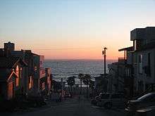
Downtown
"Downtown" Manhattan Beach is considered the heart of the city. The area runs along Manhattan Beach Boulevard and the streets perpendicular to the Manhattan Beach Pier and Valley Drive. There are many Zagat rated casual-fine dining restaurants, specialty boutiques and retailers that create a pedestrian friendly, mixed-use downtown center. The Metlox site, where the pottery factory once stood for decades, was closed in the early 1990s and redeveloped into a mixed-use center. The new Metlox site includes a luxury boutique hotel, spa, restaurants, shops and underground parking.
North Manhattan Beach District
North Manhattan Beach business district is located near the intersection of Rosecrans and Highland and has many excellent restaurants and shops. The district is defined as covering "32nd Street to 45th Street and consist[s] of over 80 businesses".[18]
Rosecrans Corridor
The "Rosecrans corridor" is located on the south side of Rosecrans Avenue, east of Sepulveda, and west of Aviation.
The Manhattan Beach Country Club, the westdrift Manhattan Beach Hotel and Golf Course, Fry's electronics, retail stores, restaurants, supermarkets, multi-story office buildings, and shopping centers border the Rosecrans corridor between Sepulveda and Aviation Boulevards. The Rosecrans corridor is adjacent to The Point[19] and Plaza El Segundo[20] off Sepulveda Blvd, which features additional retailers including Whole Foods Market.
Sepulveda Corridor
The "Sepulveda Corridor" occupies the commercial zone, and is the city's main north-south highway. The area includes the Manhattan Village Mall, which is located east of Sepulveda Boulevard between Marine and Rosecrans Avenues. The mall, built in the early 1980s, was remodeled in the late 1990s and early 2000s. The mall is anchored by Macy's on both ends and tenants include Pottery Barn, Pottery Barn Kids, Williams-Sonoma, and the Apple Store. Many restaurants such as Islands, Chili's, Olive Garden, and the Tin Roof are co-located with the mall. The Manhattan Village Mall is planning a new multimillion-dollar redevelopment which will add both outdoor and enclosed retail and restaurant space. There are several medium-size hotels, large automobile dealerships, automotive repair shops, restaurants, multi-story office buildings, medical buildings, pharmacies, banks, small shopping centers and a Target store along this corridor. Kaiser Permanente's medical offices, which include a laboratory and pharmacy, are located at 400 S. Sepulveda Blvd.[21]
Aviation Corridor
The "Aviation Corridor" is located along Aviation Boulevard (the city's eastern boundary), south of Rosecrans Avenue, and north of Marine Avenue. Aviation High School was located at the intersection of Manhattan Beach Blvd and Aviation until it closed in the early 1980s.[22] The zone includes several major entertainment and aerospace complexes, including Manhattan Beach Studios and the Northrop Grumman Space Park Complex.[23] Manhattan Beach Media Campus is home to the production of many popular releases in movies and entertainment, including the Marvel pictures "Thor" and "Iron Man 2" and both sequels to James Cameron's "Avatar" movie.[24] The studio complex is equipped with one of the largest photovoltaic solar panel rooftop installations in the area which generates approximately 1 megawatt of power.
Parks and recreation
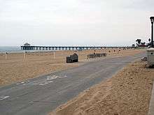
Manhattan Beach is known for its clean, wide, sandy beaches and attracts over 3.8 million visitors annually.[25] Along the Strand at the eastern edge of the beach, a concrete bike path is reserved for bicycles. The bikeway extends north to Santa Monica and south to Palos Verdes. A separate 2.1-mile (3.4 km) walkway, reserved for pedestrians, runs alongside the bike path. Restrooms and shower facilities are provided adjacent to the Strand paths. Beach volleyball, swimming, body boarding and surfing are popular activities among residents and visitors. Popular surf spots include the Pier and El Porto. Lifeguard stations are located along the entire length of the beach and the beach is cleaned and groomed daily by crews from LA County Beaches and Harbors Department.
CNNMoney named Manhattan Beach #1 as the "2011 Best Places For the Rich and Single",[26] while The Travel Channel named Manhattan Beach the 9th sexiest beach on earth for its 2008 "21 Sexiest Beaches" show.[27] Manhattan Beach has also been nicknamed the "Pearl of the South Bay" for its beauty and desirability.
There are several public parks in the city. The largest and most popular is Polliwog Park located on Manhattan Beach Boulevard, two blocks west of Aviation Boulevard. Polliwog Park has a small lake, open-air concert amphitheater, playground equipment, picnic tables, restrooms, and a fenced dog exercise area. It is also the site of the Manhattan Beach Historical Society Red Cottage, which is home to the city's collection of historical artifacts. Marine Avenue Park, west of Aviation Boulevard on Marine, has several lighted ball fields, basketball courts, and an indoor racket ball facility. A small skate park was added to Marine Avenue Park in 2017 after a 16 year battle over its location.[28] Live Oak Park in the downtown area has ball fields, playground equipment, tennis courts and picnic tables. Bruce's Beach (formerly Culiacan Park) is north of downtown.
An area known as the "Green Belt" or "Veteran's Parkway" is a pedestrian-friendly walkway that runs adjacent to Valley Drive and Ardmore Avenue near downtown Manhattan Beach. Nearly 20 acres (8.1 ha) total and comprising 3 miles (4.8 km) in length, the wood-chip walkway is a popular trail for runners and dog-walkers.
For over 50 years, the city of Manhattan Beach hosts an annual Hometown Fair[29] at Live Oak Park in downtown Manhattan Beach. Popular among community residents, the fair features food and drink, live music, games and booths to raise funds for local causes.
Demographics
| Historical population | |||
|---|---|---|---|
| Census | Pop. | %± | |
| 1920 | 859 | — | |
| 1930 | 1,891 | 120.1% | |
| 1940 | 6,398 | 238.3% | |
| 1950 | 17,330 | 170.9% | |
| 1960 | 33,934 | 95.8% | |
| 1970 | 35,352 | 4.2% | |
| 1980 | 31,542 | −10.8% | |
| 1990 | 32,063 | 1.7% | |
| 2000 | 33,852 | 5.6% | |
| 2010 | 35,135 | 3.8% | |
| Est. 2016 | 35,741 | [7] | 1.7% |
| U.S. Decennial Census[30] | |||
The 2010 United States Census[31] reported that Manhattan Beach had a population of 35,135. The population density was 8,914.7 people per square mile (3,442.0/km²). The racial makeup of Manhattan Beach was 29,686 (84.5%) White (79.3% Non-Hispanic White),[32] 290 (0.8%) Black or African American (U.S. Census), 59 (0.2%) Native American, 3,023 (8.6%) Asian, 49 (0.1%) Pacific Islander, 409 (1.2%) from other races, and 1,619 (4.6%) from two or more races. Hispanic or Latino of any race were 2,440 persons (6.9%).
The Census reported that 35,107 people (99.9% of the population) lived in households, 28 (0.1%) lived in non-institutionalized group quarters, and 0 (0%) were institutionalized.
There were 14,038 households, out of which 4,735 (33.7%) had children under the age of 18 living in them, 7,583 (54.0%) were opposite-sex married couples living together, 892 (6.4%) had a female householder with no husband present, 438 (3.1%) had a male householder with no wife present. There were 695 (5.0%) unmarried opposite-sex partnerships, and 85 (0.6%) same-sex married couples or partnerships. 3,627 households (25.8%) were made up of individuals and 1,078 (7.7%) had someone living alone who was 65 years of age or older. The average household size was 2.50. There were 8,913 families (63.5% of all households); the average family size was 3.10.
The population was spread out with 8,725 people (24.8%) under the age of 18, 1,740 people (5.0%) aged 18 to 24, 9,532 people (27.1%) aged 25 to 44, 10,681 people (30.4%) aged 45 to 64, and 4,457 people (12.7%) who were 65 years of age or older. The median age was 40.9 years. For every 100 females, there were 100.4 males. For every 100 females age 18 and over, there were 99.2 males. There were 14,929 housing units at an average density of 3,787.9 per square mile (1,462.5/km²), of which 9,420 (67.1%) were owner-occupied, and 4,618 (32.9%) were occupied by renters. The homeowner vacancy rate was 0.8%; the rental vacancy rate was 5.3%. 25,587 people (72.8% of the population) lived in owner-occupied housing units and 9,520 people (27.1%) lived in rental housing units.
According to the 2010 United States Census, Manhattan Beach had a median household income of $139,259, with 3.4% of the population living below the federal poverty line.[32]
Economy
Residential prices in Manhattan Beach are among the highest in the state of California. In 2013, the Dataquick study reported that more homes exceeding $1 million were sold in Manhattan Beach than any other city in California. Pacific Palisades, Beverly Hills, La Jolla, Malibu, Bel-Air, Orinda, Atherton, Montecito, and other high end cities in California ranked behind Manhattan Beach. The Higley 100 Census survey found that The Hill Section of Manhattan Beach is the second highest mean household income neighborhood in Los Angeles County, with Beverly Park ranking first and Beverly Hills (the 90210 section) ranking third, respectively.[33] The current median residential home price is $2.2 million according to a Nov. 23, 2014, Los Angeles Times article, and land values in Manhattan Beach rank among the highest per square foot in the nation.[16] Land values on the Manhattan Beach "Strand" are routinely around $10 million for a 3,000 square foot piece of land.
According to the City's 2010 Comprehensive Annual Financial Report,[34] the top employers in the city are:
| # | Employer | # of Employees |
|---|---|---|
| 1 | Target | 405 |
| 2 | Skechers | 362 |
| 3 | Macy's | 271 |
| 4 | Fry's Electronics | 251 |
| 5 | Marriott | 208 |
| 6 | Ralphs | 146 |
| 7 | Olive Garden | 143 |
| 8 | 24 Hour Fitness | 133 |
| 9 | Bristol Farms | 130 |
| 10 | Shade Hotel | 113 |
| 11 | Manhattan Beach Toyota | 99 |
| 12 | Houston's Restaurants | 97 |
| 13 | California Pizza Kitchen | 85 |
| 14 | Chili's | 81 |
| 15 | Belamar Hotel | 79 |
| 16 | Islands | 75 |
| 17 | REI | 62 |
Government
Local government
The city of Manhattan Beach is governed by a five-member City Council. City Council members are elected every four years. The office of the Mayor of Manhattan Beach rotates every ten months among the members of the City Council, so that each City Council member serves one term as Mayor. A City Manager is appointed by the City Council. An elected City Treasurer serves a four-year term.
The Beach Cities Health District,[35] provides health and wellness services to the residents of Hermosa Beach, Manhattan Beach, and Redondo Beach. It is funded partially by over $3 million annually from property taxes. The voters of the three beach cities elect the 5-member Board of Directors to 4-year terms. One of 78 California Health Districts,[36] it was created in 1955 as South Bay Hospital which no longer exists and took on its current name in 1993. Beach Cities Health District is now focused on real estate development and opened AdventurePlex,[37] a Manhattan Beach fitness center for kids and their families, in 2002. Filled with mazes, tunnels, outdoor rock climbing walls, complex ropes courses, and an indoor gym, AdventurePlex challenges children physically and intellectually in health-focused recreational activities.
County government
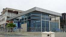
Manhattan Beach is in the Fourth Supervisorial District of Los Angeles County. Janice Hahn is the District Supervisor.[38] The county collects taxes on properties in Manhattan Beach and maintains property assessment rolls. Los Angeles County maintains the beach and provides daily cleaning and grooming. The county also maintains the bike path at the eastern edge of the beach. The Manhattan Beach County Library is located downtown on Highland Avenue two blocks north of Manhattan Beach Boulevard. The library is part of the County of Los Angeles Public Library system, and includes internet accessible computers, WiFi, and access to the six million items in the county library collection. The new $19 million, 20,000 square foot, two story facility featuring a glass exterior was completed in 2015.[39]
State legislators
In the California State Legislature, Manhattan Beach is in the 26th Senate District, represented by Democrat Ben Allen, and in the 66th Assembly District, represented by Democrat Al Muratsuchi.[40]
Federal government
In the United States House of Representatives, Manhattan Beach is in California's 33rd congressional district, represented by Democrat Ted Lieu.[41]
Education
Manhattan Beach is currently ranked as one of the best suburbs in Los Angeles Country for its high-earning and well educated residents.[42] According to US Census data, Manhattan Beach holds the ranking as the second most educated city in Los Angeles County and the fifth most educated city in the state of California.[43] Manhattan Beach's top performing school district is currently ranked as the third best in the state of California,[44] and Forbes Magazine ranked the city's school district, MBUSD, as the sixth best school district in the United States.[45]
Primary and secondary schools
| School | 2010 API Score |
|---|---|
| Grandview Elementary | 957 |
| Meadows Elementary | 946 |
| Pacific Elementary | 960 |
| Pennekamp Elementary | 948 |
| Robinson Elementary | 962 |
| Manhattan Beach Middle | 945 |
| Mira Costa High School | 911 |
Public education in Manhattan Beach is provided by the Manhattan Beach Unified School District, which oversees five elementary schools (Grand View, Meadows, Pacific, Pennekamp, Robinson), one middle school (Manhattan Beach Middle School), and one high school (Mira Costa High School).
The Manhattan Beach Unified School district is ranked as the third best-performing school district in the state of California. The district received a score of 926 on the 2010 California Academic Performance Index.[46] Each individual school also ranks at the top of its respective category.[47]
Private schools
Private schools located in Manhattan Beach include American Martyrs Catholic School, Manhattan Academy, Montessori School of Manhattan Beach and Journey of Faith Christian School.
Newspapers
Manhattan Beach is served by Easy Reader-Manhattan Beach, Beach Magazine, the Daily Breeze, the Los Angeles Times, and the Beach Reporter.
In popular culture
Filming locations
- 1408 (2007). John Cusack's character surfs in El Porto waves.
- 2012 (2009). Cracks appear down the middle of 45th Street.
- The 1983 Taylor Hackford film, Against All Odds, was filmed along The Strand and on the beach.
- George Jung of Blow fame.
- The CBS series CSI: Miami, at Manhattan Beach Studios and one episode was taken at Pollywog Park.
- The TV show Hannah Montana used Mira Costa High School as the image of the school portrayed in the TV show, and the Manhattan Beach Pier was also commonly shown in the intro of the show.
- Jerry Maguire (1996). In the movie, Dorothy's (Renée Zellweger) house is in the Gas Lamp Section on 23rd Street.
- The Fox Network series The O.C.
- Point Break (1991). In the movie, Keanu Reeves buys his surfboard from a shop located on the Manhattan Beach pier.
- Starsky and Hutch (2004). In the movie, Starsky (Ben Stiller), can be seen stretching under the pier.
- Tequila Sunrise (1988). Mel Gibson's character lives on the beach near the pier.
- The CW Television Network series Veronica Mars.
- The TV show Weeds.
- The movie Airborne.
- The video for the song "White Walls" by Macklemore.
Other
- Manhattan Beach is mentioned in the song, "Surfin' U.S.A.", by the Beach Boys. Group members were from the adjacent city of Hawthorne and surfed in Manhattan Beach.
- The Manhattan Beach Open volleyball tournament in Manhattan Beach is known as "The Championships, Wimbledon of Beach Volleyball." The names of the tournament champions are inscribed in plaques along Manhattan Beach Pier. This event usually takes place in August and is aired on national TV.
Notable people
References
- ↑ "California Cities by Incorporation Date". California Association of Local Agency Formation Commissions. Archived from the original (Word) on November 3, 2014. Retrieved August 25, 2014.
- ↑ "City Council". City of Manhattan Beach. Retrieved May 10, 2018.
- ↑ "City Treasurer". City of Manhattan Beach. Retrieved December 27, 2017.
- ↑ "2016 U.S. Gazetteer Files". United States Census Bureau. Retrieved Jun 28, 2017.
- ↑ "Manhattan Beach". Geographic Names Information System. United States Geological Survey. Retrieved December 27, 2017.
- ↑ "Manhattan Beach (city) QuickFacts". United States Census Bureau. Retrieved December 27, 2017.
- 1 2 "Population and Housing Unit Estimates". Retrieved December 27, 2017.
- ↑ "USPS - ZIP Code Lookup - Find a ZIP+ 4 Code By City Results". Retrieved December 27, 2017.
- ↑ "Number Administration System - NPA and City/Town Search Results". Retrieved December 27, 2017.
- ↑ "Mira Costa High School". www.miracostahigh.org. Retrieved December 27, 2017.
- ↑ Judson Grenier. "Capsule History of Manhattan Beach, 1912 - 1975". Retrieved December 27, 2017.
- ↑ "Monthly Averages for Manhattan Beach, California". www.weather.com. Retrieved July 10, 2018.
- ↑ Robinson, Ellen (July 5, 2014). "Manhattan ranks high among best suburbs in L.A." The Beach Reporter. Retrieved December 27, 2017.
- ↑ Gary Baum (July 25, 2013). "Manhattan Beach Real Estate Prices Go Wild". The Hollywood Reporter. Retrieved December 27, 2017.
- ↑ Reppucci, George M. "Manhattan Beach California: Width determination from a century of images"; Shore and Beach, Vol 80, No.4, Fall 2012.
- 1 2 Tony Cordi (April 1, 2010). "The Most Expensive Homes in… America". Patch Media. Retrieved December 27, 2017.
- ↑ Molly Hennessy-Freske (February 5, 2008). "Manhattan Beach draws line in sand on mansions". Los Angeles Times. Retrieved December 27, 2017.
- ↑ "Directory/Map". North Manhattan Beach California. Retrieved December 27, 2017.
- ↑ The Point Retrieved December 27, 2017.
- ↑ Plaza El Segundo Retrieved December 27, 2017.
- ↑ "Manhattan Beach Medical Office - Kaiser Permanente".
- ↑ "Manhattan Beach Studios". Archived from the original on January 19, 2009. Retrieved December 28, 2008.
- ↑ "Northrop Grumman Space Technology". Archived from the original on December 21, 2008. Retrieved December 28, 2008.
- ↑ "Archived copy". Archived from the original on February 21, 2014. Retrieved February 8, 2014.
- ↑ Estimating the potential economic impacts of climate change on Southern California beaches; Climatic Change (2011) 109 (Suppl 1):S277–S298 DOI 10.1007/s10584-011-0309-0
- ↑ "Best places for the rich and single". CNNMoney. CNN. Archived from the original on September 25, 2011. Retrieved September 20, 2011.
- ↑ "Top 10 beaches of the world 21 Sexiest Beaches 3-5". YouTube. June 18, 2009. Archived from the original on July 26, 2013. Retrieved February 8, 2013.
- ↑ "Marine Avenue Park | City of Manhattan Beach". www.citymb.info. Retrieved 2017-11-10.
- ↑ "Manhattan Beach Hometown Fair – Nothing says community like the Hometown Fair". www.mbfair.org.
- ↑ "Census of Population and Housing". Census.gov. Archived from the original on May 12, 2015. Retrieved June 4, 2015.
- ↑ "2010 Census Interactive Population Search: CA - Manhattan Beach city". U.S. Census Bureau. Retrieved July 12, 2014.
- 1 2 "State & County QuickFacts". Archived from the original on August 24, 2012.
- ↑ "Configurable Real Estate Data Reports". CoreLogic. Retrieved December 27, 2017.
- ↑ City of Manhattan Beach Comprehensive Annual Financial Report, Fiscal Year Ended June 30, 2010 Archived October 4, 2011, at the Wayback Machine.. Retrieved September 26, 2010.
- ↑ Beach Cities Health District Retrieved December 27, 2017.
- ↑ List of California Health Districts
- ↑ AdventurePlex Retrieved December 27, 2017.
- ↑ "About Supervisor Janice Hahn | Supervisor Janice Hahn". hahn.lacounty.gov. Retrieved 2018-09-04.
- ↑ Gnerre, Sam. "A look back at the history of the Manhattan Beach Library". The Beach Reporter. Retrieved 2018-09-04.
- ↑ "Statewide Database". UC Regents. Retrieved December 27, 2017.
- ↑ "California's 33rd Congressional District - Representatives & District Map". Civic Impulse, LLC.
- ↑ Ellen Robinson (July 5, 2014). "Manhattan ranks high among best suburbs in L.A." The Beach Reporter. Retrieved December 27, 2017.
- ↑ Lauren Lloyd (November 17, 2011). "Manhattan Beach Ranks As 5th Most Educated California City". Archived from the original on February 2, 2016. Retrieved December 27, 2017.
- ↑ "Find a school skills articles, book lists, videos, and milestones - GreatSchools". Parenting.
- ↑ "Manhattan Beach School District ranks 6th in the nation". Easy Reader News. May 5, 2011. Retrieved December 27, 2017.
- ↑
- ↑ Local Educational Agency (LEA) List of Schools, api.cde.ca.gov Retrieved December 27, 2017.
External links
| Wikimedia Commons has media related to Manhattan Beach, California. |
| Wikivoyage has a travel guide for Manhattan Beach. |
- Official website

- Manhattan Beach Historical Society
- Leadership Manhattan Beach
- Manhattan Beach Chamber of Commerce
- Manhattan Beach School District
- Manhattan Beach City Councilmember/Mayor Wayne Powell
- Map of original Rancho San Pedro, 1784, reflecting Rancho Sausal Redondo within its domain
Places adjacent to Manhattan Beach, California | ||||||||||
|---|---|---|---|---|---|---|---|---|---|---|
| ||||||||||

Coordinates: 33°53′20″N 118°24′19″W / 33.88889°N 118.40528°W