Waikiki
| Waikīkī | |
|---|---|
| Neighborhood of Honolulu | |
.jpg) Aerial view of Waikiki | |
| Country | United States |
| State | Hawaii |
| County | Honolulu County |
| City | Honolulu |
| Area | |
| • Total | 3.4 sq mi (9 km2) |
| ZIP Code | 96815 |
| Area code(s) | 808 |
Waikīkī (/waɪkiːˈkiː/; Hawaiian: [vɐjˈtiːˈtiː, wɐjˈtiːˈtiː]) (also known as Waikiki Beach) is a neighborhood of Honolulu on the south shore of the island of Oʻahu in the U.S. state of Hawaii.
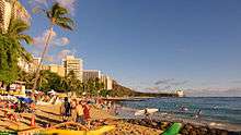
Waikiki is most famous for Waikīkī Beach, which is one of six beaches in the district, along with Queen's Beach, Kuhio Beach, Gray's Beach, Fort DeRussy Beach and Kahanamoku Beach. Waikiki Beach is almost entirely man-made.
Waikīkī is home to public places including Kapiʻolani Park, Fort DeRussy, Kahanamoku Lagoon, Kūhiō Beach Park and Ala Wai Harbor.
Etymology
Waikīkī means spouting fresh water in the Hawaiian language, for springs and streams that fed wetlands that once separated Waikīkī from the interior.[1]
History
The area was a retreat for Hawaiian royalty in the 1800s who enjoyed surfing there on early forms of longboards.[2]
A few small hotels opened in the 1880s. In 1893, Greek-American George Lycurgus leased the guest house of Allen Herbert and renamed it the "Sans Souci" (French for "without worries") creating one of the first beach resorts. Later that year Robert Louis Stevenson stayed at the resort; subsequently it became a popular destination for mainland tourists.[3] The area at coordinates 21°15′49″N 157°49′17″W / 21.26361°N 157.82139°W is still called "Sans Souci Beach".[4]
Waikiki has had erosion problems since the late-1800s, because hotels and homes were built too close to the natural shoreline, while seawalls and other structures blocked the natural ebb and flow of sand along the beach. By 1950, more than 80 structures, including seawalls, groins, piers and storm drains, occupied the Waikiki shoreline.[5]
The area became filled with large resort hotels, such as the Hilton Hawaiian Village, Halekulani, the Hyatt Regency Waikīkī, Marriott Waikiki, Sheraton Waikīkī, and historic hotels dating back to the early 20th century (such as the Moana Surfrider Hotel and the Royal Hawaiian Hotel). The beach hosts many events, including surf competitions, outdoor performances, hula dancing and outrigger canoe races. The many amenities, shops, and hotels enable Waikīkī to generate approximately 42 percent of Hawaiʻi's visitor revenue.[6]
In the early 1900s, Waikīkī was home to many wetlands, which were believed to harbor disease-carrying mosquitoes. To get rid of the mosquitoes, islanders created the Ala Wai canal. The canal, originally known as the Waikīkī Drainage Canal, was created by a Hawaiian dredging company run by Walter F. Dillingham. The project took about seven years, 1921-1928.[7]
In the early 20th century, Duke Kahanamoku became a well-known surfer in Waikiki. Throughout his life and after competing in the Olympics, many people around the world wanted to learn to surf. Duke's influence made Waikiki beach a surfing hotspot.[8] "Dukes", a club in Waikiki named for Kahanamoku, helped Don Ho produce music and hosted the longest-running show in Waikiki.[9]
In the 1920s and 1930s sand was imported from Manhattan Beach, California, via ship and barge.[10]
In the early 1900s, plans for the Ala Wai Canal were developed to help with drainage and seawalls and groynes began to appear. These helped build sand at one beach, but typically appropriated sand from others. Before 1950, Waikiki beaches were continuous. They became separated into sections, some with sandy beach and others without.
Following World War II, Waikiki beach restoration efforts have occurred every few years. Sand was imported to this artificial beach from the 1920s to the 1970s, once by boat and barge from Southern California. 1,730 feet of shoreline was replenished at a cost of $2.4 million following chronic erosion of more than a foot a year.
Importing stopped in the 1970s. In March of 1971, the Department of the Army Pacific Ocean Division, created a Draft Environmental Statement for the Kuhio Beach Sector of Waikīkī, which aimed to improve the overall quality and size of the fading and narrowing shoreline.[11]
A partial restoration was completed in the spring of 2012. The project imported sand from nearby shoals and widened the 1,700-foot (520 m) long beach by about 37 feet (11 m) between the Royal Hawaiian Hotel concrete groyne and the Kūhiō Beach crib wall. The project temporarily restored the beach to its 1985 shoreline.[12][13] Two aging sandbag groyne structures were also removed in 2012.[14]
In 2017, beach erosion worsened with “king tides” along with elevated sea level. Honolulu's mayor stated: “I’m not a scientist, but I’ll get a jackhammer in there and remove all the concrete that’s there creating this backwash and sucking out more sand, plus it’s just downright dangerous.”
Geography
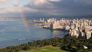
The neighborhood extends from the Ala Wai Canal (a channel dug to drain one-time wetlands) on the west and north, to Diamond Head (Lēʻahi, tuna brow) on the east. Waikīkī Beach is noted for its views of the Diamond Head tuff cone, its usually warm and cloud-free climate and its surf break.[15][16][17]
The Waikīkī skyline is filled with high-rises and resort hotels. Half of the beach is marked off for surfers. For some distance into the ocean the water is quite shallow, with numerous rocks on the bottom. The waves can have some force, particularly on windy days. The surf is known for its long rolling break, making it ideal for long boarding, tandem surfing and beginners.[18][19]
Beaches
Largely as a result of shoreline development, Waikiki has eight distinct beaches. They are Ft. DeRussy, Duke Kahanamoku, Halekulani, Royal Hawaiian, Kuhio, Kapiolani, Queens and Kaimana. Since 1951, nearly 80,000 cubic meters of sand have been added to restore Waikiki beaches. Today, however, it is believed that very little of the added sand remains.
Ala Moana Beach Park, Hawaii’s single most popular beach, is adjacent to but not technically part of Waikiki, and was also artificially made.
Thoroughfares
Waikīkī's main thoroughfare is Kalakaua Avenue, named after King Kalakaua, which houses most of the high-end hotels (Royal Hawaiian, Sheraton, Hyatt, Moana Surfrider Hotel), most of the luxury designer brand stores (Apple Store, Chanel, Louis Vuitton, Prada, Burberry, Dior, Tiffany & Co., Fendi, Cartier, Gucci, and Coach) and popular surf clothing brand stores (Quiksilver, Billabong, Volcom). Waikīkī's other main thoroughfare, Kuhio Avenue, named after Prince Kuhio, is better known for its restaurants, cafes and grocers, along with its clubs, nightlife and prostitution.[20][21]
Beach problems
Erosion


Waikīkī beach has had repeated problems with erosion, leading to the construction of groynes and beach replenishment projects. Imported sand came from California and from local beaches such as Pāpōhaku Beach on Moloka‘i, and a sandbar from Oʻahu's Northern side near Kahuku.[22] Officials look for ways to sustain the existing sand by eliminating loss due to tidal flow.[23]
Erosion claims about one foot of beach per year.[5]
Water quality
Waikiki Beach has had repeated contamination problems with sewage spills.[24][25][26]
Education
Hawaii state Department of Education operates conventional public schools throughout Hawaii. Thomas Jefferson Elementary School is located in Waikīkī proper, while Waikīkī Elementary School is located nearby, at the makai (seaward) edge of the Kapahulu neighborhood.[27]
The Hawaii State Public Library System operates the Waikīkī Public Library.[28]
Twin towns – sister cities
Waikiki is twinned with:


Gallery
 Surfboards in Waikiki
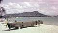 Waikīkī Beach facing Diamond Head, 1958
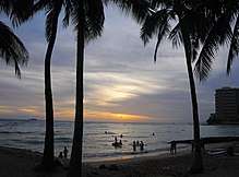
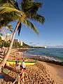 Waikiki Beach view
 Aerial view of Waikiki Beach and Honolulu, Hawaii
.jpg) Aerial view of Duke Kahanamoku Lagoon
Aerial view of Duke Kahanamoku Lagoon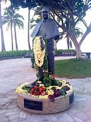 Statue of Prince Kuhio in Waikiki
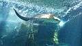 A zebra shark swimming at Waikiki Aquarium
See also
References
- ↑ Lloyd J. Soehren (2010). "lookup of waikiki ". in Hawaiian Place Names. Ulukau, the Hawaiian Electronic Library. Retrieved December 13, 2010.
- ↑ "Longboards used by royalty". Hawaii-post.com. Archived from the original on December 5, 2014. Retrieved September 3, 2012.
- ↑ Chapin, Helen G. (1981). "The Queen's "Greek Artillery Fire": Greek Royalists in the Hawaiian Revolution and Counterrevolution". Hawaiian Journal of History. 15.
- ↑ "Sans Souci Beach Park". Honolulu, HI, USA: City and County of Honolulu. August 15, 2012. Retrieved October 1, 2012.
- 1 2 Cave, James (2015-03-09). "Waikiki Beach Is Totally Man-Made (And Disappearing). Can Hawaii Save It?". Huffington Post. Retrieved 2018-08-09.
- ↑ FOX, CATHERINE TOTH (2018-02-12). "Our Waikīkī: King Tides, Beach Erosion and Water Pollution—Can Waikīkī Be Saved?". Honolulu Magazine. Retrieved 2018-04-11.
- ↑ Gaye, Chan (30 September 2006). Waikiki : A History of Forgetting and Remembering. University of Hawaii Press. Retrieved 26 April 2018.
- ↑ Wright, Katie (2005). Duke Kahanamoku: Cultural Icon. Center for Pacific Island Studies, University of Hawaii at Manoa.
- ↑ "Don Ho". TIM. Retrieved 2018-06-18.
- ↑ Beckerson, Bonnie (2001). "City of Manhattan Beach History". Archived from the original on May 16, 2010. Retrieved April 26, 2010.
- ↑ United States Army Corps of Engineers (25 March 1971). Waikiki Beach erosion control improvements, Kuhio sector : environmental impact statement. Retrieved 26 April 2018.
- ↑ "Beach to be rebuilt with recovered sand - Hawaii News". Staradvertiser.com. June 30, 2010. Archived from the original on September 21, 2012. Retrieved September 3, 2012.
- ↑ Cocke, Sophie (9 March 2015). "Waikiki Beach Is Totally Man-Made (And Disappearing). Can Hawaii Save It?". Huffington Post. Retrieved 26 April 2018.
- ↑ Habel, Shellie; Fletcher, Charles H.; Barbee, Matthew; Anderson, Tiffany R. (11 June 2016). "The influence of seasonal patterns on a beach nourishment project in a complex reef environment". Coastal Engineering. 116: 67–76.
|access-date=requires|url=(help) - ↑ "Waikiki Historic Trail - Map". Hawaii Tourism Authority. Retrieved October 1, 2012.
- ↑ Young, Peter T (May 11, 2012). "Ho'okuleana: Waikīkī – Before the Ala Wai". Retrieved October 1, 2012.
- ↑ Ejiri, Masakazu (1996). "1: Introduction". The Development of Waikiki, 1900–1949: The Formative Period of an American Resort Paradise (Thesis). Honolulu: University of Hawaiʻi at Mānoa. p. 1. Retrieved October 1, 2012.
- ↑ "Queens - Surfing in Oahu, United States of America - WannaSurf, surf spots atlas, surfing photos, maps, GPS location". wannasurf.com. Archived from the original on April 16, 2015. Retrieved April 26, 2015.
- ↑ "Canoes - Surfing in Oahu, United States of America - WannaSurf, surf spots atlas, surfing photos, maps, GPS location". wannasurf.com. Retrieved April 26, 2015.
- ↑ Gonser, James (January 26, 2004). "City to beautify Kuhio Avenue". The Honolulu Advertiser. Retrieved September 3, 2012.
- ↑ Schaefers, Allison (August 31, 2003). "Prostitution shifts from Waikiki". The Honolulu Advertiser. Retrieved September 3, 2012.
- ↑ Fox, Catherine Toth (2 February 2018). "Our Waikīkī: King Tides, Beach Erosion and Water Pollution—Can Waikīkī Be Saved?". Honolulu Magazine. Retrieved 26 April 2018.
- ↑ "Where's Waikiki's sand?". CNN. Atlanta, GA, USA: Turner Broadcasting System. July 5, 2003. Archived from the original on July 7, 2008. Retrieved October 1, 2012.
- ↑ Hanna, Jason. "Hawaii's Waikiki beaches shut after sewage spill". CNN. Retrieved 2017-03-31.
- ↑ Jerome, Sara. "Investigation Of Waikiki Beach Sewage Spill Closes". www.wateronline.com. Retrieved 2017-03-31.
- ↑ Savage, Sam; Venzon, Nel C Jr (January 30, 2008). "Massive Discharge of Untreated Sewage into the Ala Wai Canal (Oahu, Hawaii): A Threat to Waikiki's Waters?". Redorbit. Archived from the original on April 1, 2017. Retrieved March 31, 2017.
- ↑ "School Information Archived October 5, 2006, at the Wayback Machine.." Waikiki Elementary School. Retrieved on May 22, 2009.
- ↑ "Waikiki Public Library". Hawaii State Public Library System. May 22, 2009. Archived from the original on November 30, 2009. Retrieved March 1, 2016.
External links
| Wikimedia Commons has media related to Waikiki Beach. |
- Waikiki Info
- "DTS--Live Images, City and County of Honolulu, Hawaii". 2010-01-18. Archived from the original on 2010-01-18. Retrieved 2018-08-08.
Coordinates: 21°16′31″N 157°49′52″W / 21.2752°N 157.8312°W