Malkajgiri
| Malkajgiri | |
|---|---|
| Major Urban | |
 The skyline of Malkajgiri | |
 Malkajgiri Location in the state of Telangana, India  Malkajgiri Malkajgiri (India) | |
| Coordinates: 17°26′54″N 78°31′45″E / 17.44833°N 78.52917°ECoordinates: 17°26′54″N 78°31′45″E / 17.44833°N 78.52917°E | |
| Country |
|
| State | Telangana |
| District | Medchal–Malkajgiri district |
| Mandal | Malkajgiri mandal |
| City
| Hyderabad Metropolitan Region |
| Court | Metropolitan (Malkajgiri) Court . |
| Police Station | Malkajgiri Police station |
| Government | |
| • Body | GHMC , Malkajgiri Circle |
| Area | |
| • Total | 23.5 km2 (9.1 sq mi) |
| Elevation | 1,296 m (4,252 ft) |
| Population (2011) | |
| • Total | 4,13,571 |
| • Density | 18,000/km2 (46,000/sq mi) |
| Languages | |
| • Official | Telugu Telugu Urdu |
| Time zone | UTC+5:30 (IST) |
| PIN Code Postal Area and Head Office | 500047 |
| Vehicle registration | TS-08 |
| Lok Sabha constituency | Malkajgiri |
| Vidhan Sabha constituency | Malkajgiri |
| Planning agency | GHMC |
Malkajgiri is an urban area of Secunderbad city in the Medchal–Malkajgiri district of the Indian state of Telangana. It is the headquarters of Malkajgiri mandal in Malkajgiri revenue division.[1] It was a part of Ranga Reddy district before the re-organisation of districts in the state. Now it's in Medchal-Malkajgiri district. [2]
Earlier Malkajgiri was a big village , very nearer to Secunderabad , then it upgraded as Municipality. Malkajgiri mandal before bifurcated was Very bigger one, It consisted of two municipal units in one Revenue mandal. They are Malkajgiri Municipality -Malkajgiri, Moulali, Neredmet, Yapral, Kowkur. Second Alwal Municipality -Alwal ,Maccha Bollaram, Venkathapuram. , then after 2007 it merged into City -Greater Hyderabad Municipal Corporation (GHMC) , Now it is Circle in GHMC.
- After district bifurcation "or" formation Alwal Municipality became a New Mandal "Alwal mandal" .
Demographics
As of the 2011 India census,.[3] Malkajgiri had a population of 413,571. The population is 51% male and 49% female. Malkajgiri has an average literacy ratio of 87% with a total of 321,525 literates. In terms of literacy, Malkajgiri ranked at 1st in K.V.Rangareddy district, higher than the national averages of 59.5%; male literacy is 72%, and female literacy is 65%. In Malkajgiri, 7% of the population is under 6 years of age.
History
Malkajgiri mandal before bifurcated is Very bigger one, It consisted of two municipal units . They are Malkajgiri Municipality & Alwal Municipalities.
- Malkajgiri : Moulali, Neredmet, Yapral, Kowkoor.
- Alwal : Maccha Bollaram, Venkathapuram.
- After district bifurcation "or" formation Alwal Municipality became a New Mandal "Alwal mandal" .
Revenue Villages in Malkajgiri
Malkajgiri Mandal has two villages according to new district formation in 2017.
1. Malkajgiri is major village of Mandal.
- Malkajgiri village
- Moual ali village
- Neredmet (Ramakrishnapuram , Safilguda) Village
2. Other village in mandal.
- Ammuguda village (Added from Kapra Municipality).
Malkajgiri GHMC circle
- 136 Neredmet division
- 137 Vinayak nagar division
- 138 Moula Ali division
- 139 East anandbagh division
- 140 Malkajgiri division
- 141 GOUTHAM NAGAR division
Politics
The Malkajgiri Assembly Constituency is a new constituency formed after delimitation of constituencies. The General elections held in 2009 were the first elections to be held in this constituency. Akula Rajender Mudiraj was elected as MLA in 2009. In 2014 general assembly elections, C. Kanaka Reddy (TRS) won by 2768 votes against Ram Chander Rao.N (BJP).
Transport
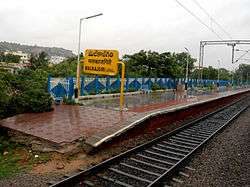
Malkajgiri is well-connected with other parts of the city by road as well as rail.The Malkajgiri Railway Station located at backside of St. Martin High School will soon be converted into a major junction. Until now the station has 4 tracks and 3 Platforms in which 2nd&3rd Platforms are only Electrified. There is a Railway Reservation Complex too.[4] thereby connecting it to most of places by rail route.
Malkajgiri is less than 15 to 20 mins drive from Secunderabad Railway Station. It is also just 3 km away from Mettuguda junction where the road leading to Uppal and the International Airport is being expanded into eight lanes.
References
- ↑ "Medchal-Malkajgiri district" (PDF). Official website of Medchal district. Retrieved 20 March 2017.
- ↑ "Medchal−Malkajgiri district" (PDF). New Districts Formation Portal. Government of Telangana. Archived from the original (PDF) on 30 November 2016. Retrieved 23 March 2017.
- ↑ "Census of India 2009: Data from the 2009 Census, including cities, villages and towns (Provisional)". Census Commission of India. Archived from the original on 2004-06-16. Retrieved 2008-11-01.
- ↑ "Proposal for the Fourth rail Terminal for Hyderabad and Electrification of whole line". The Hindu. 21 June 2006. Retrieved 25 September 2009.
| Wikimedia Commons has media related to Malkajgiri. |