Bharat Nagar
| Bharat Nagar | |
|---|---|
| Neighbourhood | |
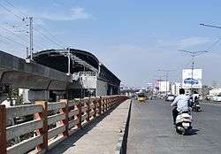 Bharat Nagar Metro Station under construction as seen from Bharat Nagar flyover | |
 Bharat Nagar Location in Telangana, India  Bharat Nagar Bharat Nagar (India) | |
| Coordinates: 17°27′48″N 78°25′44″E / 17.46333°N 78.42889°ECoordinates: 17°27′48″N 78°25′44″E / 17.46333°N 78.42889°E | |
| Country |
|
| State | Telangana |
| District | Ranga Reddy district |
| Metro | Hyderabad |
| Government | |
| • Body | GHMC |
| Languages | |
| • Official | Telugu |
| Time zone | UTC+5:30 (IST) |
| PIN | 500018 |
| Planning agency | GHMC |
| Civic agency | GHMC |
| Website |
telangana |
Bharat Nagar is one of the newer suburbs on the northwestern fringe of the city of Hyderabad, India. Prior to being incorporated into the Greater Hyderabad Municipal Corporation (GHMC), it was part of the Kukatpally municipality. At present it is located in Circle XIV of the GHMC, on Sanjeeva Reddy Nagar Main Road (NH-9) at the "Flyover", south of Moosapet. It is in the eastern part of the Motinagar election ward, #38290.[1] It is located by the Pune Hyderabad Machilipatnam highway NH 65.
Transport
Bharat Nagar is connected by buses run by TSRTC. Buses that run are 218D,113,10. There is a MMTS train station is at Bharat Nagar.[2]
The buses from Secunderabad station to Bharath Nagar are 10K, 10K/L,10K/18.
Culture
Bharath Nagar is famous for Hari Hara Temple.
References
- ↑ "Map: Delimitation of Election Wards: West Zone: Kukatpally: Circle-XIV". Greater Hyderabad Municipal Corporation (GHMC). Archived from the original on 25 April 2013.
- ↑ "Hyderabad Metro Rail Route Map".
This article is issued from
Wikipedia.
The text is licensed under Creative Commons - Attribution - Sharealike.
Additional terms may apply for the media files.