List of cities in Alaska
.svg.png)
Alaska is a state of the United States in the northwest extremity of the North American continent. According to the 2010 United States Census, Alaska is the 3rd least populous state with 710,231 inhabitants but is the largest by land area spanning 570,640.95 square miles (1,477,953.3 km2).[1] Alaska is divided administratively into 19 organized boroughs and one Unorganized Borough (which is divided into 10 non-administrative census areas) and contains 149 incorporated cities: four unified home rule municipalities, which are considered both boroughs and cities; ten home rule cities; nineteen first class cities; and 116 second class cities.[2] Alaska's incorporated cities cover only 2.1% of the territory's land mass but are home to 69.92% of its population.[1] The majority of the incorporated land mass consists of the four unified municipalities, each over 1,700 square miles (4,400 km2) in size. Only two other cities have an incorporated area exceeding 100 square miles (260 km2): Unalaska, which includes the fishing port of Dutch Harbor, and Valdez, which includes the terminus of the Trans-Alaska Pipeline System.
Incorporated cities in Alaska are categorized as either "general law" (subdivided into "first class" and "second class") or "home rule".[3] In general, the powers and functions of general law cities and home rule cities are substantially the same, with all legislative powers not prohibited by law or charter. Apart from duties such as conducting elections and holding regular meetings of the governing bodies, the duties of local cities vary considerably and are determined at the local level. Home rule cities and first class cities in the unorganized borough must, however, operate municipal school districts, exercise planning, and land use regulations while organized boroughs take on these responsibilities unless delegated to the city by the borough. Unified home rule cities (and other boroughs) also have the duty to collect municipal property and sales tax for use in their jurisdiction. Home rule cities occur when a community establishes a commission to draft a charter, which is then ratified by voters at an election. Title 29 of the Alaska Statutes, which covers municipal government, requires that a community must have at least 400 permanent residents to incorporate as a home rule or first class city.[4] This status does not diminish if a city's population declines; one home rule city (Nenana) and four first class cities (Hydaburg, Pelican, Seldovia and Tanana) reported populations falling below that threshold in the 2010 Census.[1]
The largest municipality by population in Alaska is Anchorage with 291,826 residents or approximately 41.1% of the state population.[1] The smallest municipality by population is Bettles with 12 residents.[1] The largest municipality by land area is Sitka which spans 2,870.34 sq mi (7,434.1 km2), while Kiana is the smallest at 0.19 sq mi (0.49 km2).[1] The first city to incorporate was Ketchikan in 1901 and the newest municipality is Whale Pass which incorporated in 2017.[5][6]
Incorporated cities
- Largest cities in Alaska by population
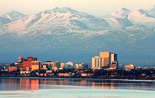 Skyline of Anchorage, Alaska's largest city by population
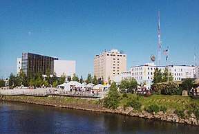 Downtown Fairbanks, the second largest city in Alaska by population
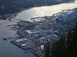 Aerial view of Juneau, Alaska's capital and third largest city by population
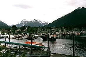 Harbor of Sitka, the fourth largest city by population in Alaska and largest by land area
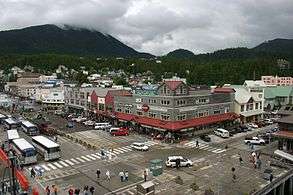 Downtown Ketchikan, the earliest extant incorporated city and fifth largest city by population in Alaska
| Name | Class[7] | Borough or Census Area[8] | Incorporated[5] | Population (2010)[1] |
Population (2000)[1] |
Change | Land area (2010)[1] |
Population density | |
|---|---|---|---|---|---|---|---|---|---|
| sq mi | km2 | ||||||||
| Adak | Second Class | Aleutians West (CA) | 2001 | 326 | 316 | +3.2% | 33.98 | 88.0 | 9.6/sq mi (3.7/km2) |
| Akhiok | Second Class | Kodiak Island | 1974 | 71 | 80 | −11.2% | 7.77 | 20.1 | 9.1/sq mi (3.5/km2) |
| Akiak | Second Class | Bethel (CA) | 1970 | 346 | 309 | +12.0% | 2.10 | 5.4 | 164.8/sq mi (63.6/km2) |
| Akutan | Second Class | Aleutians East | 1979 | 1,027 | 713 | +44.0% | 13.83 | 35.8 | 74.3/sq mi (28.7/km2) |
| Alakanuk | Second Class | Kusilvak (CA) | 1969 | 677 | 652 | +3.8% | 29.53 | 76.5 | 22.9/sq mi (8.9/km2) |
| Aleknagik | Second Class | Dillingham (CA) | 1973 | 219 | 221 | −0.9% | 24.53 | 63.5 | 8.9/sq mi (3.4/km2) |
| Allakaket | Second Class | Yukon-Koyukuk (CA) | 1975 | 105 | 97 | +8.2% | 3.01 | 7.8 | 34.9/sq mi (13.5/km2) |
| Ambler | Second Class | Northwest Arctic | 1971 | 258 | 309 | −16.5% | 8.98 | 23.3 | 28.7/sq mi (11.1/km2) |
| Anaktuvuk Pass | Second Class | North Slope | 1959 | 324 | 282 | +14.9% | 4.83 | 12.5 | 67.1/sq mi (25.9/km2) |
| Anchorage | Unified Home Rule | Anchorage | 1975 | 291,826 | 260,283 | +12.1% | 1,704.68 | 4,415.1 | 171.2/sq mi (66.1/km2) |
| Anderson | Second Class | Denali[lower-alpha 1] | 1962 | 246 | 367 | −33.0% | 43.74 | 113.3 | 5.6/sq mi (2.2/km2) |
| Angoon | Second Class | Hoonah-Angoon (CA) | 1963 | 459 | 572 | −19.8% | 24.41 | 63.2 | 18.8/sq mi (7.3/km2) |
| Aniak | Second Class | Bethel (CA) | 1972 | 501 | 572 | −12.4% | 6.42 | 16.6 | 78.0/sq mi (30.1/km2) |
| Anvik | Second Class | Yukon-Koyukuk (CA) | 1969 | 85 | 104 | −18.3% | 9.68 | 25.1 | 8.8/sq mi (3.4/km2) |
| Atka | Second Class | Aleutians West (CA) | 1988 | 61 | 92 | −33.7% | 8.74 | 22.6 | 7.0/sq mi (2.7/km2) |
| Atqasuk | Second Class | North Slope | 1982 | 233 | 228 | +2.2% | 38.71 | 100.3 | 6.0/sq mi (2.3/km2) |
| Bethel | Second Class | Bethel (CA) | 1957 | 6,080 | 5,471 | +11.1% | 43.18 | 111.8 | 140.8/sq mi (54.4/km2) |
| Bettles | Second Class | Yukon-Koyukuk (CA) | 1985 | 12 | 43 | −72.1% | 1.74 | 4.5 | 6.9/sq mi (2.7/km2) |
| Brevig Mission | Second Class | Nome (CA) | 1969 | 388 | 276 | +40.6% | 2.56 | 6.6 | 151.6/sq mi (58.5/km2) |
| Buckland | Second Class | Northwest Arctic | 1966 | 416 | 406 | +2.5% | 1.41 | 3.7 | 295.0/sq mi (113.9/km2) |
| Chefornak | Second Class | Bethel (CA) | 1974 | 418 | 394 | +6.1% | 5.72 | 14.8 | 73.1/sq mi (28.2/km2) |
| Chevak | Second Class | Kusilvak (CA) | 1967 | 938 | 765 | +22.6% | 0.99 | 2.6 | 947.5/sq mi (365.8/km2) |
| Chignik | Second Class | Lake and Peninsula | 1983 | 91 | 79 | +15.2% | 11.39 | 29.5 | 8.0/sq mi (3.1/km2) |
| Chuathbaluk | Second Class | Bethel (CA) | 1975 | 118 | 119 | −0.8% | 3.47 | 9.0 | 34.0/sq mi (13.1/km2) |
| Clark's Point | Second Class | Dillingham (CA) | 1971 | 62 | 75 | −17.3% | 3.07 | 8.0 | 20.2/sq mi (7.8/km2) |
| Coffman Cove | Second Class | Prince of Wales-Hyder (CA) | 1989 | 176 | 199 | −11.6% | 11.93 | 30.9 | 14.8/sq mi (5.7/km2) |
| Cold Bay | Second Class | Aleutians East | 1981 | 108 | 88 | +22.7% | 53.21 | 137.8 | 2.0/sq mi (0.8/km2) |
| Cordova | Home Rule | Valdez-Cordova (CA) | 1909 | 2,239 | 2,454 | −8.8% | 59.97 | 155.3 | 37.3/sq mi (14.4/km2) |
| Craig | First Class | Prince of Wales-Hyder (CA) | 1922 | 1,201 | 1,397 | −14.0% | 7.20 | 18.6 | 166.8/sq mi (64.4/km2) |
| Deering | Second Class | Northwest Arctic | 1970 | 122 | 136 | −10.3% | 5.05 | 13.1 | 24.2/sq mi (9.3/km2) |
| Delta Junction | Second Class | Southeast Fairbanks (CA) | 1960 | 958 | 840 | +14.0% | 16.82 | 43.6 | 57.0/sq mi (22.0/km2) |
| Dillingham | First Class | Dillingham (CA) | 1963 | 2,329 | 2,466 | −5.6% | 33.57 | 86.9 | 69.4/sq mi (26.8/km2) |
| Diomede | Second Class | Nome (CA) | 1970 | 115 | 146 | −21.2% | 2.84 | 7.4 | 40.5/sq mi (15.6/km2) |
| Eagle | Second Class | Southeast Fairbanks (CA) | 1901 | 86 | 129 | −33.3% | 1.00 | 2.6 | 86.0/sq mi (33.2/km2) |
| Edna Bay[lower-alpha 2] | Second Class | Prince of Wales-Hyder (CA) | 2014[9] | 42 | 49 | −14.3% | 58.80 | 152.3 | 0.8/sq mi (0.3/km2) |
| Eek | Second Class | Bethel (CA) | 1970 | 296 | 280 | +5.7% | 0.91 | 2.4 | 325.3/sq mi (125.6/km2) |
| Egegik | Second Class | Lake and Peninsula | 1995 | 109 | 116 | −6.0% | 33.03 | 85.5 | 3.3/sq mi (1.3/km2) |
| Ekwok | Second Class | Dillingham (CA) | 1974 | 115 | 130 | −11.5% | 16.27 | 42.1 | 7.1/sq mi (2.7/km2) |
| Elim | Second Class | Nome (CA) | 1970 | 330 | 313 | +5.4% | 2.42 | 6.3 | 136.4/sq mi (52.7/km2) |
| Emmonak | Second Class | Kusilvak (CA) | 1964 | 762 | 767 | −0.7% | 7.67 | 19.9 | 99.3/sq mi (38.4/km2) |
| Fairbanks | Home Rule | Fairbanks North Star | 1903[10] | 31,535 | 30,224 | +4.3% | 31.69 | 82.1 | 995.1/sq mi (384.2/km2) |
| False Pass | Second Class | Aleutians East | 1990 | 35 | 64 | −45.3% | 26.98 | 69.9 | 1.3/sq mi (0.5/km2) |
| Fort Yukon | Second Class | Yukon-Koyukuk (CA) | 1959 | 583 | 595 | −2.0% | 7.25 | 18.8 | 80.4/sq mi (31.0/km2) |
| Galena | First Class | Yukon-Koyukuk (CA) | 1971 | 470 | 675 | −30.4% | 17.73 | 45.9 | 26.5/sq mi (10.2/km2) |
| Gambell | Second Class | Nome (CA) | 1963 | 681 | 649 | +4.9% | 10.90 | 28.2 | 62.5/sq mi (24.1/km2) |
| Golovin | Second Class | Nome (CA) | 1971 | 156 | 144 | +8.3% | 3.72 | 9.6 | 41.9/sq mi (16.2/km2) |
| Goodnews Bay | Second Class | Bethel (CA) | 1970 | 243 | 230 | +5.7% | 3.72 | 9.6 | 65.3/sq mi (25.2/km2) |
| Grayling | Second Class | Yukon-Koyukuk (CA) | 1969 | 194 | 194 | 0.0% | 10.96 | 28.4 | 17.7/sq mi (6.8/km2) |
| Gustavus | Second Class | Hoonah-Angoon (CA) | 2004 | 442 | 429 | +3.0% | 32.81 | 85.0 | 13.5/sq mi (5.2/km2) |
| Holy Cross | Second Class | Yukon-Koyukuk (CA) | 1968 | 178 | 227 | −21.6% | 30.19 | 78.2 | 5.9/sq mi (2.3/km2) |
| Homer | First Class | Kenai Peninsula | 1964 | 5,003 | 3,946 | +26.8% | 13.83 | 35.8 | 361.7/sq mi (139.7/km2) |
| Hoonah | First Class | Hoonah-Angoon (CA) | 1946 | 760 | 860 | −11.6% | 6.01 | 15.6 | 126.5/sq mi (48.8/km2) |
| Hooper Bay | Second Class | Kusilvak (CA) | 1966 | 1,093 | 1,014 | +7.8% | 8.22 | 21.3 | 133.0/sq mi (51.3/km2) |
| Houston | Second Class | Matanuska-Susitna | 1966 | 1,912 | 1,202 | +59.1% | 22.40 | 58.0 | 85.4/sq mi (33.0/km2) |
| Hughes | Second Class | Yukon-Koyukuk (CA) | 1973 | 77 | 78 | −1.3% | 3.01 | 7.8 | 25.6/sq mi (9.9/km2) |
| Huslia | Second Class | Yukon-Koyukuk (CA) | 1969 | 275 | 293 | −6.1% | 16.43 | 42.6 | 16.7/sq mi (6.5/km2) |
| Hydaburg | First Class | Prince of Wales-Hyder (CA) | 1927 | 376 | 382 | −1.6% | 0.58 | 1.5 | 648.3/sq mi (250.3/km2) |
| Juneau | Unified Home Rule | Juneau | 1970 | 31,275 | 30,711 | +1.8% | 2,701.93 | 6,998.0 | 11.6/sq mi (4.5/km2) |
| Kachemak | Second Class | Kenai Peninsula | 1961 | 472 | 431 | +9.5% | 1.64 | 4.2 | 287.8/sq mi (111.1/km2) |
| Kake | First Class | Petersburg[lower-alpha 3] | 1952 | 557 | 710 | −21.5% | 8.96 | 23.2 | 62.2/sq mi (24.0/km2) |
| Kaktovik | Second Class | North Slope | 1971 | 239 | 293 | −18.4% | 0.72 | 1.9 | 331.9/sq mi (128.2/km2) |
| Kaltag | Second Class | Yukon-Koyukuk (CA) | 1969 | 190 | 230 | −17.4% | 21.59 | 55.9 | 8.8/sq mi (3.4/km2) |
| Kasaan | Second Class | Prince of Wales-Hyder (CA) | 1976 | 49 | 39 | +25.6% | 6.00 | 15.5 | 8.2/sq mi (3.2/km2) |
| Kenai | Home Rule | Kenai Peninsula | 1960 | 7,100 | 6,942 | +2.3% | 28.59 | 74.0 | 248.3/sq mi (95.9/km2) |
| Ketchikan | Home Rule | Ketchikan Gateway | 1900 | 8,050 | 7,922 | +1.6% | 4.35 | 11.3 | 1,850.6/sq mi (714.5/km2) |
| Kiana | Second Class | Northwest Arctic | 1964 | 361 | 388 | −7.0% | 0.19 | 0.49 | 1,900.0/sq mi (733.6/km2) |
| King Cove | First Class | Aleutians East | 1947 | 938 | 792 | +18.4% | 25.68 | 66.5 | 36.5/sq mi (14.1/km2) |
| Kivalina | Second Class | Northwest Arctic | 1969 | 374 | 377 | −0.8% | 1.50 | 3.9 | 249.3/sq mi (96.3/km2) |
| Klawock | First Class | Prince of Wales-Hyder (CA) | 1929 | 755 | 854 | −11.6% | 0.77 | 2.0 | 980.5/sq mi (378.6/km2) |
| Kobuk | Second Class | Northwest Arctic | 1973 | 151 | 109 | +38.5% | 16.22 | 42.0 | 9.3/sq mi (3.6/km2) |
| Kodiak | Home Rule | Kodiak Island | 1940 | 6,130 | 6,334 | −3.2% | 3.49 | 9.0 | 1,756.4/sq mi (678.2/km2) |
| Kotlik | Second Class | Kusilvak (CA) | 1970 | 577 | 591 | −2.4% | 3.78 | 9.8 | 152.6/sq mi (58.9/km2) |
| Kotzebue | Second Class | Northwest Arctic | 1958 | 3,201 | 3,082 | +3.9% | 26.92 | 69.7 | 118.9/sq mi (45.9/km2) |
| Koyuk | Second Class | Nome (CA) | 1970 | 332 | 297 | +11.8% | 4.77 | 12.4 | 69.6/sq mi (26.9/km2) |
| Koyukuk | Second Class | Yukon-Koyukuk (CA) | 1973 | 96 | 101 | −5.0% | 5.60 | 14.5 | 17.1/sq mi (6.6/km2) |
| Kupreanof | Second Class | Petersburg | 1975 | 27 | 23 | +17.4% | 3.69 | 9.6 | 7.3/sq mi (2.8/km2) |
| Kwethluk | Second Class | Bethel (CA) | 1975 | 721 | 713 | +1.1% | 10.06 | 26.1 | 71.7/sq mi (27.7/km2) |
| Larsen Bay | Second Class | Kodiak Island | 1974 | 87 | 115 | −24.3% | 5.39 | 14.0 | 16.1/sq mi (6.2/km2) |
| Lower Kalskag | Second Class | Bethel (CA) | 1969 | 282 | 267 | +5.6% | 1.22 | 3.2 | 231.1/sq mi (89.2/km2) |
| Manokotak | Second Class | Dillingham (CA) | 1970 | 442 | 399 | +10.8% | 35.74 | 92.6 | 12.4/sq mi (4.8/km2) |
| Marshall | Second Class | Kusilvak (CA) | 1970 | 414 | 349 | +18.6% | 4.58 | 11.9 | 90.4/sq mi (34.9/km2) |
| McGrath | Second Class | Yukon-Koyukuk (CA) | 1975 | 346 | 401 | −13.7% | 47.32 | 122.6 | 7.3/sq mi (2.8/km2) |
| Mekoryuk | Second Class | Bethel (CA) | 1969 | 191 | 210 | −9.0% | 6.37 | 16.5 | 30.0/sq mi (11.6/km2) |
| Mountain Village | Second Class | Kusilvak (CA) | 1967 | 813 | 755 | +7.7% | 4.54 | 11.8 | 179.1/sq mi (69.1/km2) |
| Napakiak | Second Class | Bethel (CA) | 1970 | 354 | 353 | +0.3% | 4.41 | 11.4 | 80.3/sq mi (31.0/km2) |
| Napaskiak | Second Class | Bethel (CA) | 1971 | 405 | 390 | +3.8% | 3.63 | 9.4 | 111.6/sq mi (43.1/km2) |
| Nenana | Home Rule | Yukon-Koyukuk (CA) | 1921 | 378 | 402 | −6.0% | 5.90 | 15.3 | 64.1/sq mi (24.7/km2) |
| New Stuyahok | Second Class | Dillingham (CA) | 1972 | 510 | 471 | +8.3% | 32.48 | 84.1 | 15.7/sq mi (6.1/km2) |
| Newhalen | Second Class | Lake and Peninsula[lower-alpha 4] | 1971 | 190 | 160 | +18.8% | 5.90 | 15.3 | 32.2/sq mi (12.4/km2) |
| Nightmute | Second Class | Bethel (CA) | 1974 | 280 | 208 | +34.6% | 96.89 | 250.9 | 2.9/sq mi (1.1/km2) |
| Nikolai | Second Class | Yukon-Koyukuk (CA) | 1970 | 94 | 100 | −6.0% | 4.60 | 11.9 | 20.4/sq mi (7.9/km2) |
| Nome | First Class | Nome (CA) | 1901 | 3,598 | 3,505 | +2.7% | 12.63 | 32.7 | 284.9/sq mi (110.0/km2) |
| Nondalton | Second Class | Lake and Peninsula | 1971 | 164 | 221 | −25.8% | 8.21 | 21.3 | 20.0/sq mi (7.7/km2) |
| Noorvik | Second Class | Northwest Arctic | 1964 | 668 | 634 | +5.4% | 0.94 | 2.4 | 710.6/sq mi (274.4/km2) |
| North Pole | Home Rule | Fairbanks North Star | 1953 | 2,117 | 1,570 | +34.8% | 4.17 | 10.8 | 507.7/sq mi (196.0/km2) |
| Nuiqsut | Second Class | North Slope | 1975 | 402 | 433 | −7.2% | 9.42 | 24.4 | 42.7/sq mi (16.5/km2) |
| Nulato | Second Class | Yukon-Koyukuk (CA) | 1963 | 264 | 336 | −21.4% | 41.56 | 107.6 | 6.4/sq mi (2.5/km2) |
| Nunam Iqua | Second Class | Kusilvak (CA) | 1974 | 187 | 164 | +14.0% | 12.13 | 31.4 | 15.4/sq mi (6.0/km2) |
| Nunapitchuk | Second Class | Bethel (CA) | 1969 | 496 | 466 | +6.4% | 7.46 | 19.3 | 66.5/sq mi (25.7/km2) |
| Old Harbor | Second Class | Kodiak Island | 1966 | 218 | 237 | −8.0% | 20.53 | 53.2 | 10.6/sq mi (4.1/km2) |
| Ouzinkie | Second Class | Kodiak Island | 1967 | 161 | 225 | −28.4% | 5.46 | 14.1 | 29.5/sq mi (11.4/km2) |
| Palmer | Home Rule | Matanuska-Susitna | 1951 | 5,937 | 4,533 | +31.0% | 5.15 | 13.3 | 1,152.8/sq mi (445.1/km2) |
| Pelican | First Class | Hoonah-Angoon (CA) | 1943 | 88 | 163 | −46.0% | 0.60 | 1.6 | 146.7/sq mi (56.6/km2) |
| Pilot Point | Second Class | Lake and Peninsula | 1992 | 68 | 100 | −32.0% | 26.14 | 67.7 | 2.6/sq mi (1.0/km2) |
| Pilot Station | Second Class | Kusilvak (CA) | 1969 | 568 | 550 | +3.3% | 1.69 | 4.4 | 336.1/sq mi (129.8/km2) |
| Platinum | Second Class | Bethel (CA) | 1975 | 61 | 41 | +48.8% | 45.07 | 116.7 | 1.4/sq mi (0.5/km2) |
| Point Hope | Second Class | North Slope | 1966 | 674 | 757 | −11.0% | 4.82 | 12.5 | 139.8/sq mi (54.0/km2) |
| Port Alexander | Second Class | Petersburg | 1974 | 52 | 81 | −35.8% | 3.47 | 9.0 | 15.0/sq mi (5.8/km2) |
| Port Heiden | Second Class | Lake and Peninsula | 1972 | 102 | 119 | −14.3% | 50.63 | 131.1 | 2.0/sq mi (0.8/km2) |
| Port Lions | Second Class | Kodiak Island | 1966 | 194 | 256 | −24.2% | 6.38 | 16.5 | 30.4/sq mi (11.7/km2) |
| Quinhagak | Second Class | Bethel (CA) | 1975 | 669 | 555 | +20.5% | 4.37 | 11.3 | 153.1/sq mi (59.1/km2) |
| Ruby | Second Class | Yukon-Koyukuk (CA) | 1973 | 166 | 188 | −11.7% | 7.63 | 19.8 | 21.8/sq mi (8.4/km2) |
| Russian Mission | Second Class | Kusilvak (CA) | 1970 | 312 | 296 | +5.4% | 5.58 | 14.5 | 55.9/sq mi (21.6/km2) |
| Saint Paul | Second Class | Aleutians West (CA) | 1971 | 479 | 532 | −10.0% | 40.31 | 104.4 | 11.9/sq mi (4.6/km2) |
| Sand Point | First Class | Aleutians East | 1966 | 976 | 952 | +2.5% | 7.70 | 19.9 | 126.8/sq mi (48.9/km2) |
| Savoonga | Second Class | Nome (CA) | 1969 | 671 | 643 | +4.4% | 6.10 | 15.8 | 110.0/sq mi (42.5/km2) |
| Saxman | Second Class | Ketchikan Gateway | 1929 | 411 | 431 | −4.6% | 0.98 | 2.5 | 419.4/sq mi (161.9/km2) |
| Scammon Bay | Second Class | Kusilvak (CA) | 1967 | 474 | 465 | +1.9% | 0.62 | 1.6 | 764.5/sq mi (295.2/km2) |
| Selawik | Second Class | Northwest Arctic | 1977[lower-alpha 5] | 829 | 772 | +7.4% | 2.93 | 7.6 | 282.9/sq mi (109.2/km2) |
| Seldovia | First Class | Kenai Peninsula | 1945 | 255 | 286 | −10.8% | 0.37 | 0.96 | 689.2/sq mi (266.1/km2) |
| Seward | Home Rule | Kenai Peninsula | 1912 | 2,693 | 2,830 | −4.8% | 14.11 | 36.5 | 190.9/sq mi (73.7/km2) |
| Shageluk | Second Class | Yukon-Koyukuk (CA) | 1970 | 83 | 129 | −35.7% | 11.09 | 28.7 | 7.5/sq mi (2.9/km2) |
| Shaktoolik | Second Class | Nome (CA) | 1969 | 251 | 230 | +9.1% | 1.04 | 2.7 | 241.3/sq mi (93.2/km2) |
| Shishmaref | Second Class | Nome (CA) | 1969 | 563 | 562 | +0.2% | 2.22 | 5.7 | 253.6/sq mi (97.9/km2) |
| Shungnak | Second Class | Northwest Arctic | 1967 | 262 | 256 | +2.3% | 8.92 | 23.1 | 29.4/sq mi (11.3/km2) |
| Sitka | Unified Home Rule | Sitka | 1971 | 8,881 | 8,835 | +0.5% | 2,870.34 | 7,434.1 | 3.1/sq mi (1.2/km2) |
| Soldotna | Home Rule[11] | Kenai Peninsula | 1967 | 4,163 | 3,759 | +10.7% | 6.90 | 17.9 | 603.3/sq mi (232.9/km2) |
| St. George | Second Class | Aleutians West (CA) | 1983 | 102 | 152 | −32.9% | 34.75 | 90.0 | 2.9/sq mi (1.1/km2) |
| St. Mary's | First Class | Kusilvak (CA) | 1967 | 507 | 500 | +1.4% | 44.29 | 114.7 | 11.4/sq mi (4.4/km2) |
| St. Michael | Second Class | Nome (CA) | 1969 | 401 | 368 | +9.0% | 20.02 | 51.9 | 20.0/sq mi (7.7/km2) |
| Stebbins | Second Class | Nome (CA) | 1969 | 556 | 547 | +1.6% | 36.37 | 94.2 | 15.3/sq mi (5.9/km2) |
| Tanana | First Class | Yukon-Koyukuk (CA) | 1961 | 246 | 308 | −20.1% | 11.04 | 28.6 | 22.3/sq mi (8.6/km2) |
| Teller | Second Class | Nome (CA) | 1963 | 229 | 268 | −14.6% | 1.89 | 4.9 | 121.2/sq mi (46.8/km2) |
| Tenakee Springs | Second Class | Hoonah-Angoon (CA) | 1971 | 131 | 104 | +26.0% | 14.19 | 36.8 | 9.2/sq mi (3.6/km2) |
| Thorne Bay | Second Class | Prince of Wales-Hyder (CA) | 1982 | 471 | 557 | −15.4% | 26.58 | 68.8 | 17.7/sq mi (6.8/km2) |
| Togiak | Second Class | Dillingham (CA) | 1969 | 817 | 809 | +1.0% | 44.42 | 115.0 | 18.4/sq mi (7.1/km2) |
| Toksook Bay | Second Class | Bethel (CA) | 1972 | 590 | 532 | +10.9% | 32.64 | 84.5 | 18.1/sq mi (7.0/km2) |
| Unalakleet | Second Class | Nome (CA) | 1974 | 688 | 747 | −7.9% | 3.63 | 9.4 | 189.5/sq mi (73.2/km2) |
| Unalaska | First Class | Aleutians West (CA) | 1942 | 4,376 | 4,283 | +2.2% | 111.78 | 289.5 | 39.1/sq mi (15.1/km2) |
| Upper Kalskag | Second Class | Bethel (CA) | 1975 | 210 | 230 | −8.7% | 3.69 | 9.6 | 56.9/sq mi (22.0/km2) |
| Utqiaġvik | First Class | North Slope | 1959 | 4,212 | 4,581 | −8.1% | 18.84 | 48.8 | 223.6/sq mi (86.3/km2) |
| Valdez | Home Rule | Valdez-Cordova (CA) | 1901 | 3,976 | 4,036 | −1.5% | 216.24 | 560.1 | 18.4/sq mi (7.1/km2) |
| Wainwright | Second Class | North Slope | 1962 | 556 | 546 | +1.8% | 17.94 | 46.5 | 31.0/sq mi (12.0/km2) |
| Wales | Second Class | Nome (CA) | 1964 | 145 | 152 | −4.6% | 2.52 | 6.5 | 57.5/sq mi (22.2/km2) |
| Wasilla | First Class | Matanuska-Susitna | 1974 | 7,831 | 5,469 | +43.2% | 12.38 | 32.1 | 632.6/sq mi (244.2/km2) |
| Whale Pass[lower-alpha 6] | Second Class | Prince of Wales-Hyder (CA) | 2017[6] | 31 | 58 | −46.6% | 37.40 | 96.9 | 0.8/sq mi (0.3/km2) |
| White Mountain | Second Class | Nome (CA) | 1969 | 190 | 203 | −6.4% | 1.80 | 4.7 | 105.6/sq mi (40.8/km2) |
| Whittier | Second Class | Valdez-Cordova (CA) | 1969 | 220 | 182 | +20.9% | 12.27 | 31.8 | 17.9/sq mi (6.9/km2) |
| Wrangell | Unified Home Rule | Wrangell | 2008 | 2,369 | 2,308 | +2.6% | 2,541.48 | 6,582.4 | 0.9/sq mi (0.4/km2) |
| Total[lower-alpha 7] | – | – | – | 496,565 | 457,229 | +8.6% | 12,182.77 | 31,553.2 | 40.8/sq mi (15.7/km2) |
- Notes
- ↑ The Borough seat is Healy, a census-designated place.
- ↑ Edna Bay incorporated in October 2014 and thus not included in the sums for the 2010 or 2000 censuses.
- ↑ The Borough seat is Petersburg, a census-designated place.
- ↑ The Borough seat is King Salmon, a census-designated place, and is located in neighboring Bristol Bay Borough.
- ↑ A conflict as to the date exists between sources: 1996 Alaska Municipal Officials Directory (p. 136) gives 1977, while "Directory of Borough and City Officials 1974" (p. 72) gives December 23, 1963. It is unclear whether Selawik may have dissolved and later reincorporated its city government.
- ↑ Whale Pass incorporated in 2017 and thus not included in the sums for the 2010 or 2000 censuses.[6]
- ↑ The totals reflect the 2010 Census numbers and thus include Petersburg, with a population of 2948 and a land area of 44.13 square miles (114.3 km2), which dissolved its city government in 2013 in favor of incorporating as a borough. [12]
See also
References
- 1 2 3 4 5 6 7 8 9 "GCT-PH1 — Population, Housing Units, Area, and Density: 2010 — State – Place and (in selected states) County Subdivision". 2010 United States Census. United States Census Bureau. Retrieved June 17, 2015.
- ↑ 2015 Alaska Municipal Officials Directory. Juneau: Alaska Municipal League. 2015. p. ix.
- ↑ "Municipal Government Structure in Alaska". Local Government On-Line, Division of Community and Regional Affairs, Alaska Department of Commerce, Community and Economic Development. September 15, 2003. Archived from the original on September 13, 2008. Retrieved July 16, 2008.
- ↑ "Local Government In Alaska" (PDF). Alaska Department of Commerce, Community and Economic Development. February 2001. Archived from the original (PDF) on July 18, 2008. Retrieved July 16, 2008.
- 1 2 "Directory of Borough and City Officials 1974". Alaska Local Government. Juneau. XIII (2): 45. January 1974.
- 1 2 3 Denning, Angela. "Whale Pass voters approve incorporation | KFSK". Retrieved 2017-01-10.
- ↑ "Alaska Taxable 2011: Municipal Taxation - Rates and Policies" (PDF). Division of Community and Regional Affairs, Alaska Department of Commerce, Community and Economic Development. January 2012. Archived from the original (PDF) on April 25, 2013. Retrieved January 23, 2013.
- ↑ "Background on Boroughs in Alaska" (PDF). Local Boundary Commission, Division of Community and Regional Affairs, Alaska Department of Commerce, Community and Economic Development. November 2000. Retrieved July 16, 2008.
- ↑ Bell, Susan (September 10, 2014). "Edna Bay Incorporates as Alaska's Newest City" (PDF) (Press release). Juneau, Alaska: Commissioner's Office. Department of Commerce, Community, and Economic Development, Division of Community and Regional Affairs. Retrieved May 21, 2016.
- ↑ 1996 Alaska Municipal Officials Directory. Juneau: Alaska Municipal League/Alaska Department of Community and Regional Affairs. January 1996. p. 55.
- ↑ "Soldotna home-rule charter passes". Peninsula Clarion. Morris Publishing Group, LLC. Retrieved 20 September 2018.
- ↑ Lagoudakis, Cindi; Menish-Meucci, Marilyn. "Fact Sheet". petersburgak.org. Petersburg Chamber of Commerce/Visitor Information Center. Retrieved June 23, 2018.
Juneau (capital) | ||
| Topics |  | |
| Society | ||
| Regions | ||
| Largest cities pop. over 25,000 | ||
| Smaller cities pop. over 2,000 | ||
| Boroughs | ||
| Census Areas | ||