King Cove, Alaska
| King Cove | |
|---|---|
| City | |
 King Cove Location in Alaska | |
| Coordinates: 55°4′20″N 162°19′5″W / 55.07222°N 162.31806°WCoordinates: 55°4′20″N 162°19′5″W / 55.07222°N 162.31806°W | |
| Country | United States |
| State | Alaska |
| Borough | Aleutians East |
| Incorporated | September 9, 1949[1] |
| Government | |
| • Mayor | Henry Mack[2] |
| • State senator | Lyman Hoffman (D) |
| • State rep. | Bryce Edgmon (D) |
| Area[3] | |
| • Total | 29.91 sq mi (77.48 km2) |
| • Land | 25.68 sq mi (66.50 km2) |
| • Water | 4.24 sq mi (10.97 km2) |
| Elevation | 92 ft (28 m) |
| Population (2010)[4] | |
| • Total | 938 |
| • Estimate (2016)[5] | 989 |
| • Density | 33.06/sq mi (12.77/km2) |
| Time zone | UTC-9 (Alaska (AKST)) |
| • Summer (DST) | UTC-8 (AKDT) |
| ZIP code | 99612 |
| Area code | 907 |
| FIPS code | 02-39410 |
| Website | http://www.cityofkingcove.com/ |
King Cove (Agdaaĝux̂[6] in Aleut) is a city in Aleutians East Borough, Alaska, United States. As of the 2010 census, its population was 938. This was up from 792 in 2000. The 2016 estimate was 989.
Geography
King Cove is located at 55°04′20″N 162°19′05″W / 55.072125°N 162.318040°W.[7] King Cove is on the pacific side of the Alaska Peninsula. It is 18 miles (29 km) southeast of Cold Bay and 620 miles (1,000 km) southwest of Anchorage. It lies at approximately 55* 03'N Latitude and 162* 19' W Longitude. The area encompasses 2.9 square miles (8 km2) of land and 2.0 square miles (5 km2) of water.
According to the U.S. Census Bureau, the city has a total area of 29.8 square miles (77 km2), of which, 25.3 square miles (66 km2) is land and 4.5 square miles (12 km2) (15.23%) is water.
Demographics
| Historical population | |||
|---|---|---|---|
| Census | Pop. | %± | |
| 1940 | 135 | — | |
| 1950 | 162 | 20.0% | |
| 1960 | 290 | 79.0% | |
| 1970 | 283 | −2.4% | |
| 1980 | 460 | 62.5% | |
| 1990 | 451 | −2.0% | |
| 2000 | 792 | 75.6% | |
| 2010 | 938 | 18.4% | |
| Est. 2016 | 989 | [5] | 5.4% |
| U.S. Decennial Census[8] | |||
King Cove first appeared on the 1940 U.S. Census as an unincorporated village. It formally incorporated in 1949.
As of the census[9] of 2000, there were 792 people, 170 households, and 116 families residing in the city. The population density was 31.3 people per square mile (12.1/km²). There were 207 housing units at an average density of 8.2 per square mile (3.2/km²). The racial makeup of the city was 15.03% White, 1.64% Black or African American, 46.72% Native American, 26.77% Asian, 0.13% Pacific Islander, 5.93% from other races, and 3.79% from two or more races. 7.45% of the population were Hispanic or Latino of any race.
There were 170 households out of which 45.3% had children under the age of 18 living with them, 46.5% were married couples living together, 15.9% had a female householder with no husband present, and 31.2% were non-families. 25.3% of all households were made up of individuals and 2.9% had someone living alone who was 65 years of age or older. The average household size was 2.90 and the average family size was 3.53.
In the city, the age distribution of the population shows 21.3% under the age of 18, 11.9% from 18 to 24, 41.0% from 25 to 44, 22.7% from 45 to 64, and 3.0% who were 65 years of age or older. The median age was 35 years. For every 100 females, there were 147.5 males. For every 100 females age 18 and over, there were 166.2 males.
The median income for a household in the city was $45,893, and the median income for a family was $47,188. Males had a median income of $30,714 versus $19,125 for females. The per capita income for the city was $17,791. About 3.3% of families and 11.9% of the population were below the poverty line, including 1.7% of those under age 18 and 27.3% of those age 65 or over.
Economy
King Cove, 600 nautical miles (1,000 km) SW of Anchorage at the end of the Alaska Peninsula, is home to PeterPan Seafoods' largest processing facility. King Crab, bairdi and opilio tanner crab, pollock, cod, salmon, halibut and black cod harvested in the Bering Sea and the Gulf of Alaska are processed throughout the year. The plant, with origins back to the early 1900s, has the largest salmon canning capacity of any plant in Alaska. All five species of salmon are abundant in the waters near King Cove.
Salmon remains a major part of the annual operation, but in recent years the plant has expanded and streamlined whitefish operations. The plant produces several product forms including pollock fillet block, shatterpack fillets, mince and surimi. Cod shatterpack fillets and salt cod are mainstays. At peak seasons, both winter and summer, nearly 500 employees staff the operation. King Cove's economy depends almost completely on the year-round commercial fishing and seafood processing industries. The PeterPan Seafoods' facility is one of the largest cannery operations under one roof in Alaska. 76 residents hold commercial fishing permits. Income is supplemented by subsistence activities.[10]
The community is served by King Cove Airport, a state-owned public use airport with a gravel runway. A locally based FAA certificated Part 135 company called Eider Air provides on demand air-taxi service and charter operations to villagers and visitors. Grant Aviation also flys to King Cove, and has the contract for mail services.
It is also served by the Alaska Marine Highway, the state-run ferry service which connects it Cold Bay in the west and Sand Point in the east.[11]
A partially completed road between King Cove and Cold Bay is awaiting approval through the USDOI. This road would pass through the Izembek Wilderness, causing irreparable damage to the preserve per governmental assessments according to a report generated by The Wilderness Society . The previous negative decision by former USDOI director Sally Jewell is being reconsidered to include a land swap. Proponents of the road state it would help local citizens in need of medical evacuation when airplanes can not land or take off from the local airport due to darkness or weather conditions. Opponents contend the road's main purpose is, as it always has been, to provide a link between King Cove and a nearby airport for commercial reasons. No evidence has been put forward to support a road would be safer in difficult weather condition than air transport. On 22 January 2018, Interior Secretary Ryan Zinke signed a land swap agreement to allow construction of the road.[12]
Healthcare
The King Cove Community Health Clinic is run by the Eastern Aleutian Tribes and provides routine medical care, behavioral health, and emergency care services. The clinic is open Monday through Friday during normal business hours, closed for all Alaskan and Federal holidays. After hours emergencies are handled by on-call practitioners. There is an active local emergency medical services group who provide ambulance service. Care is also provided through Community Health Aide Practitioners, which are unique to Alaska.
Education
Aleutians East Borough School District (AEBSD) operates the King Cove School.[13]
Circa October 1978 the school had 13 teachers and 84 students. At the time King Cove school was in its own school district.[14]
References
- ↑ http://www.akbizmag.com/Alaska-Business-Monthly/September-2009/The-City-of-King-Cove-Celebrates-its-60th-Birthday-As-an-Incorporated-City/
- ↑ 2015 Alaska Municipal Officials Directory. Juneau: Alaska Municipal League. 2015. p. 86.
- ↑ "2016 U.S. Gazetteer Files". United States Census Bureau. Retrieved Jun 22, 2017.
- ↑ "2010 City Population and Housing Occupancy Status". U.S. Census Bureau. Archived from the original on July 21, 2011. Retrieved May 14, 2012.
- 1 2 "Population and Housing Unit Estimates". Retrieved June 9, 2017.
- ↑ Bergsland, K. (1994). Aleut Dictionary. Fairbanks: Alaska Native Language Center.
- ↑ "US Gazetteer files: 2010, 2000, and 1990". United States Census Bureau. 2011-02-12. Retrieved 2011-04-23.
- ↑ "Census of Population and Housing". Census.gov. Archived from the original on May 12, 2015. Retrieved June 4, 2015.
- ↑ "American FactFinder". United States Census Bureau. Retrieved 2008-01-31.
- ↑ "King Cove". PeterPan Seafoods, Inc.
- ↑ "King Cove Alaska". Alaska Ferry Community Information. Alaska Department of Transportation. Retrieved 21 July 2017.
- ↑ Eilperin, Juliet (22 January 2018). "Energy and Environment Zinke signs land-swap deal allowing road through Alaska's Izembek wilderness". Washington Post. Retrieved 23 January 2018.
- ↑ "Schools." Aleutians East Borough School District. Retrieved on February 20, 2017.
- ↑ Aleutian Islands, Aleutian Peninsula Debris Removal: Environmental Impact Statement. United States Army Corps of Engineers, 1980. p. 58.
Municipalities and communities of Aleutians East Borough, Alaska, United States | ||
|---|---|---|
| Cities | 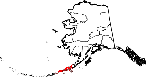 | |
| CDP | ||
| Unincorporated communities | ||
| Ghost towns | ||