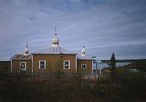
Chuathbaluk, Alaska
| Chuathbaluk Curarpalek | |
|---|---|
| City | |
 | |
 Chuathbaluk Location in Alaska | |
| Coordinates: 61°34′32″N 159°14′50″W / 61.57556°N 159.24722°W | |
| Country | United States |
| State | Alaska |
| Census area | Bethel |
| Incorporated | 1975[1] |
| Government | |
| • Mayor | Agrafenia Pletnikoff |
| • State senator | Lyman Hoffman (D) |
| • State rep. | Tiffany Zulkosky (R) |
| Area[2] | |
| • Total | 5.19 sq mi (13.44 km2) |
| • Land | 3.47 sq mi (8.98 km2) |
| • Water | 1.72 sq mi (4.46 km2) |
| Elevation | 154 ft (47 m) |
| Population (2010) | |
| • Total | 118 |
| • Estimate (2016)[3] | 126 |
| • Density | 24.29/sq mi (9.38/km2) |
| Time zone | UTC-9 (Alaska (AKST)) |
| • Summer (DST) | UTC-8 (AKDT) |
| Area code | 907 |
| FIPS code | 02-14330 |
| GNIS feature ID | 1400376 |
Chuathbaluk (Curarpalek in Central Alaskan Yup'ik) is a city in Bethel Census Area, Alaska, United States. At the 2010 census the population was 118,[4] down from 119 in 2000.
Geography
Chuathbaluk is located at 61°34′32″N 159°14′50″W / 61.57556°N 159.24722°W (61.575693, -159.247311),[5] on the Kuskokwim River, approximately 100 miles (160 km) upstream from Bethel. The Russian Mountains are a small circular mountain range just to the north of the town.
According to the United States Census Bureau, the city has a total area of 5.2 square miles (13.4 km2), of which 3.5 square miles (9.0 km2) is land and 1.7 square miles (4.5 km2), or 33.19%, is water.[4]
Demographics
| Historical population | |||
|---|---|---|---|
| Census | Pop. | %± | |
| 1970 | 94 | — | |
| 1980 | 105 | 11.7% | |
| 1990 | 97 | −7.6% | |
| 2000 | 119 | 22.7% | |
| 2010 | 118 | −0.8% | |
| Est. 2016 | 126 | [3] | 6.8% |
| U.S. Decennial Census[6] | |||
Chuathbaluk first appeared on the 1970 census as an unincorporated village. It formally incorporated in 1975. Prior to that, the community had been known as "Russian Mission." This was not to be confused with the present city of the same name, so it was often called the Little Russian Mission to avoid confusion. Under the prior name, it never reported a population separately.[7]
As of the census[8] of 2000, there were 119 people, 33 households, and 23 families residing in the city. The population density was 33.8 people per square mile (13.1/km²). There were 43 housing units at an average density of 12.2 per square mile (4.7/km²). The racial makeup of the city was 5.04% White, 91.60% Native American, 0.84% from other races, and 2.52% from two or more races.
There were 33 households out of which 45.5% had children under the age of 18 living with them, 30.3% were married couples living together, 27.3% had a female householder with no husband present, and 27.3% were non-families. 21.2% of all households were made up of individuals and 3.0% had someone living alone who was 65 years of age or older. The average household size was 3.61 and the average family size was 4.21.
In the city, the age distribution of the population shows 42.9% under the age of 18, 8.4% from 18 to 24, 28.6% from 25 to 44, 16.0% from 45 to 64, and 4.2% who were 65 years of age or older. The median age was 23 years. For every 100 females, there were 91.9 males. For every 100 females age 18 and over, there were 106.1 males.
The median income for a household in the city was $34,286, and the median income for a family was $34,167. Males had a median income of $46,250 versus $28,750 for females. The per capita income for the city was $10,100. There were 16.7% of families and 24.1% of the population living below the poverty line, including 27.5% of under eighteens and none of those over 64.
History
Chuathbaluk was the site of an Ingalik Indian summer fish camp in the mid-19th century. The village has been known as Chukbak, St. Sergius Mission, Kuskokwim Russian Mission, and Little Russian Mission. The village was often confused with Russian Mission on the Yukon, so in the 1960s the name was changed to Chuathbaluk, which is derived from the Yup'ik word Curapalek, meaning "the hills where the big blueberries grow." The Russian Orthodox Church built the St. Sergius Mission by 1894, and residents of Kukuktuk from 20 miles (32 km) downriver moved to the mission. Much of the village was lost in an influenza epidemic in 1900. By 1929, the site was deserted, although Russian Orthodox members continued to hold services at the mission. In 1954, the Crow Village Sam Phillips family from Crow Village resettled the mission, and were joined later by individuals from Aniak and Crooked Creek. The church was rebuilt in the late 1950s, and a state school opened in the 1960s. The city was incorporated in 1975.
References
- ↑ 1996 Alaska Municipal Officials Directory. Juneau: Alaska Municipal League/Alaska Department of Community and Regional Affairs. January 1996. p. 39.
- ↑ "2016 U.S. Gazetteer Files". United States Census Bureau. Retrieved Jun 22, 2017.
- 1 2 "Population and Housing Unit Estimates". Retrieved June 9, 2017.
- 1 2 "Geographic Identifiers: 2010 Demographic Profile Data (G001): Chuathbaluk city, Alaska". U.S. Census Bureau, American Factfinder. Retrieved September 18, 2013.
- ↑ "US Gazetteer files: 2010, 2000, and 1990". United States Census Bureau. 2011-02-12. Retrieved 2011-04-23.
- ↑ "Census of Population and Housing". Census.gov. Archived from the original on May 12, 2015. Retrieved June 4, 2015.
- ↑ https://books.google.com/books?id=Rr9RAQAAMAAJ&pg=PA49&lpg=PA49&dq=%22Agaligamute%22&source=bl&ots=Tzy-F6Dup7&sig=B81GmrTlcKv3jtL_iWMYTwV3FSo&hl=en&sa=X&ved=0ahUKEwj69sDB-MLUAhXD2T4KHTt1Dc0Q6AEILjAD#v=onepage&q=russian%20mission&f=false
- ↑ "American FactFinder". United States Census Bureau. Archived from the original on 2013-09-11. Retrieved 2008-01-31.
Coordinates: 61°34′32″N 159°14′50″W / 61.575693°N 159.247311°W
Municipalities and communities of Bethel Census Area, Alaska, United States | ||
|---|---|---|
| Cities | 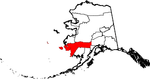 | |
| CDPs | ||
| Unincorporated communities | ||
| Ghost towns | ||