| [3] |
Name on the Register |
Image |
Date listed[4] |
Location |
City or town |
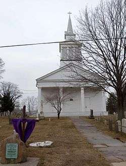
Description |
|---|
| 1 |
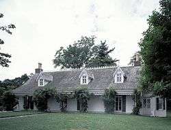
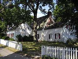
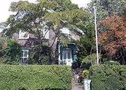
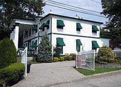
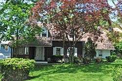
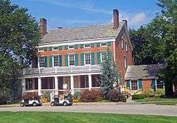
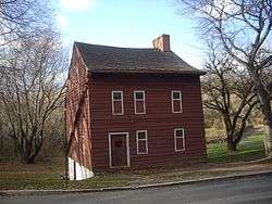
Elizabeth Alice Austen House – Clear Comfort |
|
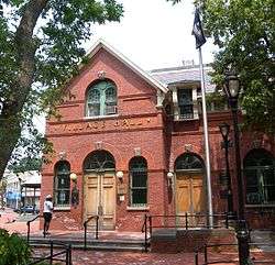
July 28, 1970
(#70000925) |
2 Hylan Boulevard
40°36′54″N 74°03′49″W / 40.615°N 74.063611°W / 40.615; -74.063611 (Elizabeth Alice Austen House – Clear Comfort) |
Rosebank |
|
| 2 |
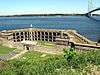
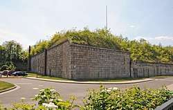
Battery Weed |
|
January 20, 1972
(#72000908) |
Fort Wadsworth Reservation
40°36′19″N 74°03′17″W / 40.605278°N 74.054722°W / 40.605278; -74.054722 (Battery Weed) |
Fort Wadsworth |
|
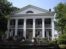
| 3 |
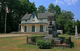
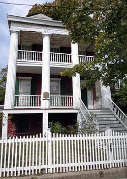
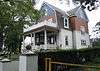
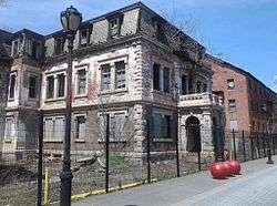
Billiou-Stillwell-Perine House |
|
January 1, 1976
(#76001269) |
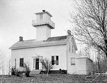
1476 Richmond Rd.
40°35′34″N 74°06′03″W / 40.592778°N 74.100833°W / 40.592778; -74.100833 (Billiou-Stillwell-Perine House) |
Dongan Hills |
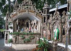
|
| 4 |
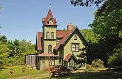
Building at One Pendleton Place |
|
October 20, 2014
(#14000874) |
1 Pendleton Place
40°38′29″N 74°05′32″W / 40.6414°N 74.0921°W / 40.6414; -74.0921 (Building at One Pendleton Place) |
New Brighton |
1860 village is rare surviving High Victorian Picturesque structure in New York City |
| 5 |
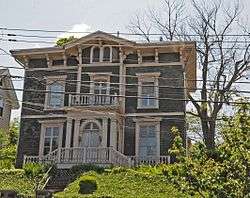
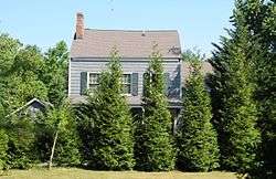
Boardman–Mitchell House |
|
January 4, 2012
(#11001004) |
710 Bay St.
40°37′29″N 74°04′29″W / 40.624667°N 74.074861°W / 40.624667; -74.074861 (Boardman–Mitchell House) |
Stapleton |
|
| 6 |
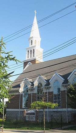
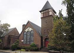
Brighton Heights Reformed Church |
|
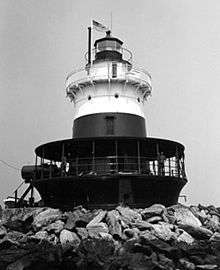
June 3, 1982
(#82003399) |
320 St. Mark
40°38′29″N 74°04′43″W / 40.641389°N 74.078611°W / 40.641389; -74.078611 (Brighton Heights Reformed Church) |
Brighton Heights |
|
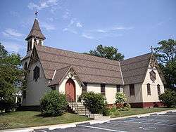
| 7 |
Calvary Presbyterian Church |
|
November 21, 2002
(#02001356) |
909 Castleton Ave.
40°38′06″N 74°06′47″W / 40.635°N 74.113056°W / 40.635; -74.113056 (Calvary Presbyterian Church) |
West New Brighton |
|
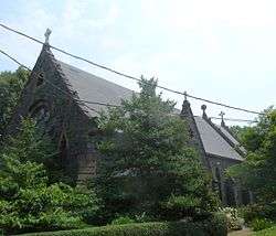
| 8 |
Christ Church New Brighton (Episcopal) |
|
May 27, 2004
(#04000544) |
76 Franklin Ave.
40°38′36″N 74°05′36″W / 40.643333°N 74.093333°W / 40.643333; -74.093333 (Christ Church New Brighton (Episcopal)) |
New Brighton |
|
| 9 |
Church of St. Andrew (Episcopal) |
|
October 6, 2000
(#82005078) |
Arthur Kill and Old Mill Rds.
40°34′22″N 74°08′51″W / 40.572778°N 74.1475°W / 40.572778; -74.1475 (Church of St. Andrew (Episcopal)) |
Richmondtown |
|
| 10 |
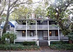
Conference House |
|
October 15, 1966
(#66000566) |
Hylan Boulevard
40°30′10″N 74°15′14″W / 40.502778°N 74.253889°W / 40.502778; -74.253889 (Conference House) |
Tottenville |
|
| 11 |
Edgewater Village Hall and Tappen Park |
|
May 19, 1980
(#80002756) |
Bounded by Wright, Water, Bay, and Canal Sts.
40°37′36″N 74°04′40″W / 40.626667°N 74.077778°W / 40.626667; -74.077778 (Edgewater Village Hall and Tappen Park) |
Stapleton |
|
| 12 |
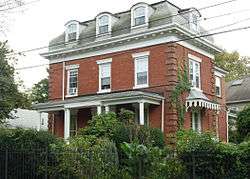
Dr. Samuel MacKenzie Elliott House |
|
March 28, 1980
(#80002757) |
69 Delafield Pl.
40°38′38″N 74°06′37″W / 40.643889°N 74.110278°W / 40.643889; -74.110278 (Dr. Samuel MacKenzie Elliott House) |
West New Brighton |
|
| 13 |
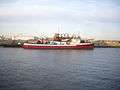
FIREFIGHTER |
|
June 30, 1989
(#89001447) |
Docked at Saint George
40°37′47″N 74°04′21″W / 40.629803°N 74.072520°W / 40.629803; -74.072520 (FIREFIGHTER) |
Staten Island |
|
| 14 |
Fort Tompkins Quadrangle |
|
July 30, 1974
(#74001300) |
Building 137, Fort Wadsworth
40°36′00″N 74°03′40″W / 40.6°N 74.061111°W / 40.6; -74.061111 (Fort Tompkins Quadrangle) |
Fort Wadsworth |
|
| 15 |
Gardiner-Tyler House |
|
November 23, 1984
(#84000294) |
27 Tyler St.
40°37′24″N 74°06′48″W / 40.623333°N 74.113333°W / 40.623333; -74.113333 (Gardiner-Tyler House) |
West New Brighton |
|
| 16 |
Garibaldi Memorial |
|
April 17, 1980
(#80002758) |
420 Tompkins Ave.
40°36′54″N 74°04′27″W / 40.615°N 74.074167°W / 40.615; -74.074167 (Garibaldi Memorial) |
Rosebank |
|
| 17 |
Hamilton Park Community Houses |
|
September 26, 1983
(#83003437) |
105 Franklin Ave., 66 Harvard Ave., and 32 Park Pl.
40°38′30″N 74°05′27″W / 40.641667°N 74.090833°W / 40.641667; -74.090833 (Hamilton Park Community Houses) |
New Brighton |
|
| 18 |
House at 5910 Amboy Road |
|
December 16, 1982
(#82001263) |
5910 Amboy Rd.
40°31′32″N 74°12′17″W / 40.525556°N 74.204722°W / 40.525556; -74.204722 (House at 5910 Amboy Road) |
Prince's Bay |
|
| 19 |
Peter Houseman House |
|
October 29, 1982
(#82001261) |
308 St. John Ave.
40°36′57″N 74°08′12″W / 40.615833°N 74.136667°W / 40.615833; -74.136667 (Peter Houseman House) |
Westerleigh |
|
| 20 |
Houses at 364 and 390 Van Duzer Street |
|
November 14, 1982
(#82001262) |
364 and 390 Van Duzer St.
40°37′45″N 74°04′47″W / 40.629167°N 74.079722°W / 40.629167; -74.079722 (Houses at 364 and 390 Van Duzer Street) |
Stapleton |
|
| 21 |
Immanuel Union Church |
|
July 27, 2018
(#100002742) |
693 Jewett Ave
40°37′13″N 74°07′52″W / 40.62024°N 74.13120°W / 40.62024; -74.13120 (Immanuel Union Church) |
Westerleigh |
Church complex built as centerpiece of Prohibition Park in late 19th and early 20th centuries spurred residential development in the neighborhood. |
| 22 |
Jacques Marchais Center of Tibetan Art |
|
May 29, 2009
(#09000379) |
338 Lighthouse Ave.
40°34′35″N 74°08′19″W / 40.576342°N 74.138478°W / 40.576342; -74.138478 (Jacques Marchais Center of Tibetan Art) |
Egbertville |
|
| 23 |
Kreischer House |
|
October 29, 1982
(#82001199) |
4500 Arthur Kill Rd.
40°31′57″N 74°14′18″W / 40.5325°N 74.238333°W / 40.5325; -74.238333 (Kreischer House) |
Charleston |
Built about 1885. |
| 24 |
Kreuzer-Pelton House |
|
January 29, 1973
(#73001261) |
1262 Richmond Ter.
40°38′37″N 74°06′43″W / 40.643611°N 74.111944°W / 40.643611; -74.111944 (Kreuzer-Pelton House) |
West New Brighton |
|
| 25 |
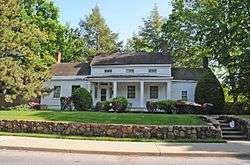
LaTourette House |
|
March 5, 1982
(#82003400) |
Richmond Hill
40°34′34″N 74°08′50″W / 40.576111°N 74.147222°W / 40.576111; -74.147222 (LaTourette House) |
New Springville |
1836 brick Federal-style building now used as clubhouse for city-owned golf course |
| 26 |
McFarlane-Bredt House |
|
September 8, 1983
(#83001784) |
30 Hylan Boulevard
40°36′51″N 74°03′51″W / 40.614167°N 74.064167°W / 40.614167; -74.064167 (McFarlane-Bredt House) |
Rosebank |
|
| 27 |
Miller Army Air Field Historic District |
|
April 11, 1980
(#80000362) |
New Dorp Lane
40°33′51″N 74°05′44″W / 40.564167°N 74.095556°W / 40.564167; -74.095556 (Miller Army Air Field Historic District) |
New Dorp Beach |
|
| 28 |
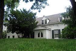
Moore-McMillen House |
|
April 23, 1980
(#80002760) |
3531 Richmond Rd.
40°34′21″N 74°08′21″W / 40.5725°N 74.139167°W / 40.5725; -74.139167 (Moore-McMillen House) |
Egbertville |
|
| 29 |
Neville House |
|
July 28, 1977
(#77000979) |
806 Richmond Terrace
40°38′40″N 74°05′57″W / 40.644444°N 74.099167°W / 40.644444; -74.099167 (Neville House) |
New Brighton |
|
| 30 |
New Brighton Village Hall |
|
December 15, 1978
(#78001904) |
66 Lafayette Ave.
40°38′35″N 74°05′46″W / 40.643056°N 74.096111°W / 40.643056; -74.096111 (New Brighton Village Hall) |
New Brighton |
|
| 31 |
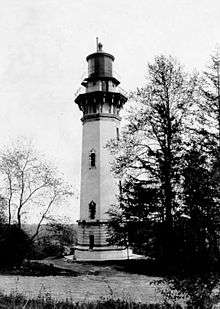
New Dorp Light |
|
August 28, 1973
(#73001260) |
Altamont Ave., Staten Island
40°34′51″N 74°07′13″W / 40.580803°N 74.120186°W / 40.580803; -74.120186 (New Dorp Light) |
New Dorp |
|
| 32 |
Office Building and U.S. Light-House Depot Complex |
|
September 15, 1983
(#83001785) |
1 Bay St.
40°38′28″N 74°04′30″W / 40.641111°N 74.075°W / 40.641111; -74.075 (Office Building and U.S. Light-House Depot Complex) |
St. George |
|
| 33 |
Old Orchard Shoal Light Station |
|
September 20, 2006
(#06000864) |
In Lower New York Bay, 3.5 miles south of New Dorp Beach
40°30′44″N 74°05′56″W / 40.512222°N 74.098889°W / 40.512222; -74.098889 (Old Orchard Shoal Light Station) |
Lower New York Bay |
|
| 34 |
Our Lady of Mount Carmel Grotto |
|
November 2, 2000
(#00001276) |
36 Amity St.
40°36′44″N 74°04′31″W / 40.612222°N 74.075278°W / 40.612222; -74.075278 (Our Lady of Mount Carmel Grotto) |
Rosebank |
|
| 35 |
Poillon-Seguine-Britton House |
|
February 2, 1984
(#84002942) |
360 Great Kills Rd.
40°32′44″N 74°08′25″W / 40.545556°N 74.140278°W / 40.545556; -74.140278 (Poillon-Seguine-Britton House) |
Great Kills |
|
| 36 |
Reformed Church on Staten Island |
|
January 20, 2005
(#04001533) |
54 Port Richmond Ave.
40°38′23″N 74°07′58″W / 40.639722°N 74.132778°W / 40.639722; -74.132778 (Reformed Church on Staten Island) |
Port Richmond |
|
| 37 |
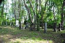
Richmond Terrace Cemeteries |
|
March 22, 2016
(#16000112) |
1562 Richmond Terrace and 25 Van St.
40°38′22″N 74°07′16″W / 40.639311°N 74.121016°W / 40.639311; -74.121016 (Richmond Terrace Cemeteries) |
West New Brighton |
Three contiguous cemeteries established between 1802 and 1866 contain graves of many early residents of the Factoryville and West New Brighton neighborhoods |
| 38 |
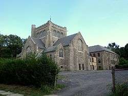
Sailors' Snug Harbor National Register District |
|
March 16, 1972
(#72000909) |
Richmond Ter.
40°38′33″N 74°06′10″W / 40.6425°N 74.102778°W / 40.6425; -74.102778 (Sailors' Snug Harbor National Register District) |
Livingston |
|
| 39 |
Sandy Ground Historic Archeological District |
|
September 23, 1982
(#82003398) |
Address Restricted
|
Sandy Ground |
|
| 40 |
Scott-Edwards House |
|
February 11, 1983
(#83001786) |
752 Delafiel Ave.
40°37′43″N 74°07′26″W / 40.628611°N 74.123889°W / 40.628611; -74.123889 (Scott-Edwards House) |
West New Brighton |
|
| 41 |
Seaview Hospital |
|
September 7, 2005
(#05000992) |
460 Brielle Ave.
40°35′30″N 74°07′58″W / 40.591667°N 74.13278°W / 40.591667; -74.13278 (Seaview Hospital) |
Willowbrook |
|
| 42 |
Seguine House |
|
May 6, 1980
(#80002761) |
440 Seguine Ave.
40°31′00″N 74°11′52″W / 40.516667°N 74.197778°W / 40.516667; -74.197778 (Seguine House) |
Lemon Creek |
|
| 43 |
Silver Lake Cemetery |
|
February 21, 2017
(#100000660) |
926 Victory Blvd.
40°37′20″N 74°05′47″W / 40.622321°N 74.096328°W / 40.622321; -74.096328 (Silver Lake Cemetery) |
Silver Lake |
|
| 44 |
St. Alban's Episcopal Church |
|
October 29, 1982
(#82001264) |
76 St. Alban's Place
40°32′37″N 74°09′40″W / 40.543611°N 74.161111°W / 40.543611; -74.161111 (St. Alban's Episcopal Church) |
Eltingville |
|
| 45 |
St. Paul's Memorial Church and Rectory |
|
November 21, 1980
(#80002762) |
225 St. Pauls Ave.
40°37′55″N 74°04′46″W / 40.631944°N 74.079444°W / 40.631944; -74.079444 (St. Paul's Memorial Church and Rectory) |
Stapleton |
|
| 46 |
STANDARD OIL COMPANY NO. 16 (harbor tug) |
|
November 29, 2001
(#01001321) |
3001 Richmond Terrace
40°38′18″N 74°09′35″W / 40.638333°N 74.159722°W / 40.638333; -74.159722 (STANDARD OIL COMPANY NO. 16 (harbor tug)) |
Mariners Harbor |
|
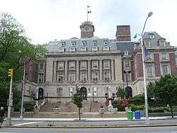
| 47 |
Staten Island Borough Hall and Richmond County Courthouse |
|
October 6, 1983
(#83004150) |
Richmond Terr.
40°38′33″N 74°04′35″W / 40.6425°N 74.076389°W / 40.6425; -74.076389 (Staten Island Borough Hall and Richmond County Courthouse) |
St. George |
|
| 48 |
Staten Island Light |
|
November 30, 2005
(#05001340) |
Southern side of Edinboro Rd., between 402 and 426 Rds.
40°34′34″N 74°08′29″W / 40.576011°N 74.141258°W / 40.576011; -74.141258 (Staten Island Light) |
Lighthouse Hill |
|
| 49 |
Louis A. and Laura Stirn House |
|
November 12, 2010
(#10000899) |
79 Howard Ave.
40°37′43″N 74°05′18″W / 40.628611°N 74.088333°W / 40.628611; -74.088333 (Louis A. and Laura Stirn House) |
Grymes Hill |
|
| 50 |
Sylvan Grove Cemetery |
|
August 24, 2015
(#15000540) |
Victory Boulevard at Glen St.
40°35′28″N 74°11′31″W / 40.591°N 74.192°W / 40.591; -74.192 (Sylvan Grove Cemetery) |
Travis–Chelsea |
Established 1795, many people important in developing Staten Island are buried here. |
| 51 |
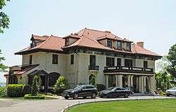
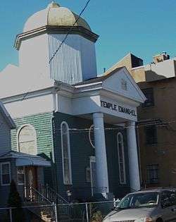
Temple Emanu-El |
|
August 2, 2007
(#07000778) |
984 Post Ave.
40°37′56″N 74°08′03″W / 40.632222°N 74.134167°W / 40.632222; -74.134167 (Temple Emanu-El) |
Port Richmond |
|
| 52 |
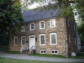
Voorlezer's House |
|
October 15, 1966
(#66000565) |
Arthur Kill Rd., opposite Center St.
40°34′18″N 74°08′52″W / 40.571667°N 74.147778°W / 40.571667; -74.147778 (Voorlezer's House) |
Richmondtown |
|
| 53 |
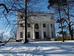
Caleb T. Ward Mansion |
|
July 26, 1982
(#82003401) |
141 Nixon Ave.
40°38′03″N 74°04′53″W / 40.634167°N 74.081389°W / 40.634167; -74.081389 (Caleb T. Ward Mansion) |
Ward Hill |
|
| 54 |
Ward's Point Conservation Area |
|
September 29, 1982
(#82003402) |
Address Restricted
|
Tottenville |
|
| 55 |
Wards Point Archeological Site |
|
April 19, 1993
(#93000609) |
Address Restricted
|
Tottenville |
|
| 56 |
West Bank Light Station |
|
January 9, 2007
(#06001230) |
In lower New York Bay, 3.3 miles east of New Dorp Beach
40°32′17″N 74°02′35″W / 40.538056°N 74.043056°W / 40.538056; -74.043056 (West Bank Light Station) |
New Dorp Beach |
|
| 57 |
Woodrow Methodist Church |
|
October 29, 1982
(#82001265) |
1109 Woodrow Rd.
40°32′35″N 74°12′04″W / 40.543056°N 74.2012°W / 40.543056; -74.2012 (Woodrow Methodist Church) |
Woodrow |
|

.jpg)
_Light.JPG)