Great Kills, Staten Island

Great Kills is a neighborhood within New York City's borough of Staten Island. It is located on the island's South Shore, and according to many local geographers, it is the South Shore's northernmost community. It is bordered by Richmondtown to the north, Bay Terrace to the east, Eltingville to the west, and Great Kills Harbor to the south.[1]
Kill is an archaic Dutch word with various popular translations, including "creek" and "channel". Indeed, many small streams dot the neighborhood, and the name can be interpreted as meaning that a great number of such streams can be found there.
The ZIP Code for Great Kills is 10308. The neighborhood is represented in the New York City Council by Joseph Borelli.
History
The eastern half of what has been known since 1865 as Great Kills was originally named Clarendon after a British colonial governor, and the western half was named Newtown. For a time, both were known as Giffords, after Daniel Gifford, a local commissioner and surveyor.[2][3] The name survives in Giffords Lane and Giffords Glen, which are adjacent to the Great Kills train station that was formerly named Giffords, and also in the Gifford School, PS 32.
Another name associated with the neighborhood is Honeywood, which survived as the name of the telephone exchange for many South Shore communities through the late 1950s. When dial service arrived, YUkon 8 replaced HOneywood 6.
The 17th-century Poillon-Seguine-Britton House near Great Kills Harbor was added to the National Register of Historic Places in 1984, but was burned in 1989 and demolished in 1996.[4] Great Kills and Staten Island's other East Shore neighborhoods were mostly rural and dotted with shoreline resorts until the 1950s, after which the Verrazano-Narrows Bridge brought heavy residential growth from Brooklyn.[1]
Recreation
The neighborhood is home to Great Kills Little League, one of eight Little Leagues on Staten Island. Actor Rick Schroder lived in the community as a child, as did actress Alyssa Milano, musician Roy Clark, comedians Joey Faye,[5] Bob Levy and Pete Davidson,[6] and Jersey Shore cast member Angelina Pivarnick.[7]
Located right beside the Great Kills Little League is the Great Kills Swim Club. This is a private club that belongs to over 500 families and competes in swimming and diving with other swim clubs in the borough. The Great Kills Swim Club is also the site of the 2015 movie Staten Island Summer written by comedian Colin Jost, who was a lifeguard there as a teenager.[8]
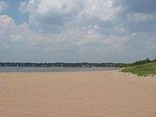
At the southeastern corner of the neighborhood is Great Kills Park, part of the Gateway National Recreation Area. The park includes a beach, trails, fishing and bird-watching areas, sports fields, and the Nichols Marina,[9] with several private marinas nearby.
Facilities

FDNY Engine Company 162/Ladder Company 82 and Battalion 23 serve Great Kills from a firehouse on Nelson Avenue, and Myra S. Barnes I.S. 24 is one of Staten Island's middle schools. Firefighter Scott Davidson, lost in the September 11 attacks of 2001, attended I.S. 24, and is one of 29 victims memorialized by an eternal flame at St. Clare's Church, the neighborhood's prominent Catholic parish.
I.S. 24 is named for the local educator and civic activist Myra S. Barnes (1880–1962). Dubbed the "Fighting Lady", she was well known for highlighting Staten Island issues to the New York City government.[10]
New York Public Library operates the Great Kills Branch at 56 Giffords Lane at Margaret Street.[11] The United States Postal Service operates the Great Kills Post Office at 1 Nelson Avenue across from the train station.[12]
Transportation
Great Kills is served by the Staten Island Railway and numerous local and express buses. The railway serves the neighborhood via the Great Kills station, located at Giffords Lane near Amboy Road. Express train service between Great Kills and the St. George Ferry Terminal is maintained during the morning and evening weekday rush hours, while local trains serve the station 24/7.[13] Local buses are the S54, S74, S78, S79 and S84, and Manhattan express buses are the SIM1, SIM5, SIM6, SIM7, SIM9 and SIM10.[14][15] Parallel to Amboy Road, the neighborhood's other major commercial streets are Arthur Kill Road and Hylan Boulevard.[1]
References
- 1 2 3 Philip S. Gutis, "If you're thinking of living in: Great Kills", New York Times, January 12, 1986.
- ↑ Stanford M. Forrester, "Great Kills", in The Encyclopedia of New York City: Second Edition, edited by Kenneth T. Jackson, Lisa Keller, Nancy Flood. Yale University Press, 2010. Retrieved June 28, 2018.
- ↑ "Crescent Beach Park", NYC Department of Parks & Recreation. Retrieved June 28, 2018.
- ↑ National Park Service (2010-07-09). "National Register Information System". National Register of Historic Places. National Park Service.
- ↑ "Famous Staten Islanders from all walks of life", Staten Island Advance, April 23, 2012.
- ↑ Lauren Steussy, "Staten Island native Pete Davidson, son of 9/11 hero, joining cast of 'Saturday Night Live'", Staten Island Advance, September 15, 2014.
- ↑ Victoria Priola, "19 things to know before 'Jersey Shore' returns for 'Family Vacation'", Staten Island Advance, November 28, 2017.
- ↑ Justin Rocket Silverman, "Colin Jost recalls summer fun on Staten Island in 'Saturday Night Live' star's first movie", New York Daily News, July 20, 2015.
- ↑ "Staten Island Unit", Gateway National Recreation Area, National Park Service. Retrieved June 28, 2018.
- ↑ Myra S. Barnes Intermediate School 24, Student/Family Handbook, June 2017.
- ↑ "Great Kills Branch", New York Public Library. Retrieved July 3, 2018.
- ↑ "Great Kills Post Office", United States Postal Service. Retrieved July 3, 2018.
- ↑ "Staten Island Railway Map", Metropolitan Transporation Authority. Retrieved June 30, 2018.
- ↑ "Staten Island Bus Map" (PDF). Metropolitan Transportation Authority. August 2018. Retrieved August 18, 2018.
- ↑ "Staten Island Express Bus Network", Metropolitan Transporation Authority. Retrieved October 13, 2018.
External links
| Wikimedia Commons has media related to Great Kills, Staten Island. |
- "Vintage Photos of Great Kills", Staten Island Advance, June 24-29, 2016.
- Ted Doerzbacher, "A fond remembrance of Staten Island's Great Kills community from a life-long resident", Staten Island Advance, January 19, 2014.
Coordinates: 40°33′15″N 74°09′07″W / 40.55417°N 74.15194°W