Lafayette, California
| City of Lafayette | |
|---|---|
| City | |
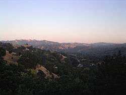 A view of Lafayette, California | |
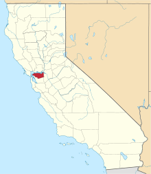
 Location of Lafayette in Contra Costa County, California. | |
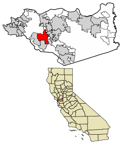
 City of Lafayette Location in the United States | |
| Coordinates: 37°53′09″N 122°07′05″W / 37.88583°N 122.11806°WCoordinates: 37°53′09″N 122°07′05″W / 37.88583°N 122.11806°W | |
| Country |
|
| State |
|
| County | Contra Costa |
| Settled | 1848 |
| Founded | 1857 |
| Incorporated | July 29, 1968[1] |
| Government | |
| • Mayor | Don Tatzin[2] |
| • State Senator | Steve Glazer (D)[3] |
| • State Assembly | Catharine Baker (R)[4] |
| • U. S. Congress | Mark DeSaulnier (D)[5] |
| Area[6] | |
| • Total | 15.21 sq mi (39.40 km2) |
| • Land | 15.05 sq mi (38.97 km2) |
| • Water | 0.17 sq mi (0.43 km2) 1.08% |
| Elevation | 320 ft (97.5 m) |
| Population (2010) | |
| • Total | 23,893 |
| • Estimate (2016)[7] | 26,103 |
| • Density | 1,734.76/sq mi (669.80/km2) |
| Time zone | UTC-8 (PST) |
| • Summer (DST) | UTC-7 (PDT) |
| ZIP codes | 94549 |
| Area code(s) | 925 |
| FIPS code | 06-39122 |
| GNIS feature IDs | 277535, 2411591 |
| Website |
www |
Lafayette (formerly, La Fayette)[8] is a city in Contra Costa County, California, United States. As of 2011, the city's population was estimated to be 24,285. It was named after the Marquis de La Fayette, a French military hero of the American Revolutionary War. Today Lafayette is known for its pastoral rolling hills, good schools, and wealthy inhabitants. In 2016, the median household income in Lafayette was over $140,000, more than twice the statewide average and about two and half times the national median.[9]
Origin and early history
Before the colonization of the region by Spain, Lafayette and its vicinity were inhabited by the Saclan tribe of the indigenous Bay Miwok. Ohlone also populated some of the areas along Lafayette Creek.[10] The indigenous inhabitants' first contact with Europeans was in the late 18th century with the founding of Catholic missions in the region. These initial contacts developed into conflict, with years of armed struggle, including a battle on what is currently Lafayette soil in 1797 between the Saclan and the Spanish, and eventually resulting in the subjugation of the native population.
Most of what is currently Lafayette was given as a Mexican land grant, Rancho Acalanes to Candelario Valencia in 1834. The name Acalanes seems to have come from the name of a native village in the area, Ahala-n.[11]
American settlement started with the arrival of Elam Brown from St. Joseph, Missouri,[12] in 1846.[8] He purchased Rancho Acalanes in 1848. The settlement continued to steadily grow due to its proximity to San Francisco; starting with Brown's group of 18 settlers, by the census in 1852, 76 people were listed as living in the area.[13] Brown founded a mill in 1853.[8] A school began in 1852[14] in a one-room schoolhouse, taught by a 25-year-old Kentucky migrant, Benjamin Shreve. By 1865 the school had expanded to 43 students in five classes, and so in 1868 a tax levy of $1,000 was used to build a new schoolhouse; school expanded from a five-month year to a nine-month year. In 1893, a new schoolhouse was built to accommodate the increasing number of students; this building still stands today.
On March 2, 1857, the LaFayette post office was established by the U.S. Postal Service. (The official document giving this exact date was supplied to the Lafayette Historical Society in 1993 by the Historical Division of the U.S. Postal Service.) Prior to 1857 the community that is now known as "Lafayette" actually had no known name - though there are undocumented rumors that it was called Dog Town, Brown's Corner, Brown's Mill, Acalanus, and perhaps Centerville.
The name "LaFayette" came together with the community's first post office. In 1857 Benjamin Shreve, owner and manager of a roadside hotel-general store (which faced today's Lafayette Plaza), applied for a post office for the community, first requesting the name Centerville. When informed that a post office with that name already existed in California, Shreve suggested La Fayette, after the French general who became a hero of the American Revolution (probably not because his wife was a native of Lafayette, Indiana). The first LaFayette post office was established at 3535 Plaza Way and Shreve became the town's first permanent postmaster, holding the job for 30 years.
Spelling: On the original document from the U.S. Postal Service, dated March 2, 1857, the name “LaFayette” is unmistakably written as one word with a capital “F” in the middle. In 1864 the place name "Lafayette" first appeared on a map of the area, titled "Bancroft's Map of California, Nevada, Utah and Arizona (copyrighted 1863. Scale: 24 miles to 1 inch). Yet research by Ruth Dyer, Lafayette historian, shows that the name of the post office and of the new town itself soon began to be written as two words, “La Fayette.” By 1890 it had changed to one word, "Lafayette," and so appeared in an official communication from the U.S. "Post Office Department" in Feb. 1899. Then by 1905 it was back to two words. Finally on March 31, 1932 the name of the post office was officially changed to Lafayette, which has remained unchanged to this day. Lafayette was the tenth post office established in Contra Costa County. (See Salley, History of California Post Offices).[15]
In the early 1860s, Lafayette was briefly the site of a station for the Pony Express.[16]
During the mid-1900s, Lafayette was transformed from an agricultural village into a commuter town, and was incorporated in 1968.
Geography and climate
Lafayette is located at 37°53′09″N 122°07′05″W / 37.88583°N 122.11806°W.[17] According to the United States Census Bureau, the city has a total area of 15.4 square miles (40 km2). 15.2 square miles (39 km2) of it is land and 0.2 square miles (0.52 km2) of it (1.08%) is water.
The city is part of the greater San Francisco Bay Area and has its own station on the BART public transit system. Lafayette is situated between Walnut Creek, Moraga, and Orinda, and, together with the latter two towns, is considered locally as part of "Lamorinda".
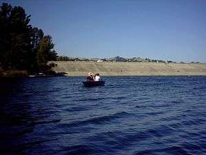
Lafayette is separated from greater Berkeley and Oakland by the Berkeley Hills (and the Caldecott Tunnel running beneath), a geographical boundary within the East Bay which also represents interesting meteorological, cultural, and political distinctions. Like the rest of the San Francisco Bay Area, Lafayette has a Mediterranean climate (Köppen climate classification Csa); however, the climate differences can be striking: during the summer, temperatures can soar beyond 100 °F (38 °C) in Lafayette and its neighboring cities while the areas west of the hills and nearer to the bay remain up to 20 degrees cooler. Summers are warm, dry and very sunny (although mornings can be foggy); winters are cool and damp, with occasional freezes. Most of the annual rainfall comes in the winter, although there are still plenty of clear days during that time. The record high temperature is 115 °F (46 °C), set in July 1972. The record low temperature is 19 °F (−7 °C), set in December 1990.[18] The region directly east of the hills is generally known for its more suburban or rural atmosphere, and features rolling, grassy hills which highlight a more peaceful and domestic aura. In the southwestern part of Lafayette, is the Lafayette Reservoir, and Briones Regional Park extends into the northern part of Lafayette. Lafayette's wildlife communities include mixed woods and oak woodlands.
| Climate data for Lafayette, California | |||||||||||||
|---|---|---|---|---|---|---|---|---|---|---|---|---|---|
| Month | Jan | Feb | Mar | Apr | May | Jun | Jul | Aug | Sep | Oct | Nov | Dec | Year |
| Record high °F (°C) | 71 (22) |
80 (27) |
88 (31) |
98 (37) |
104 (40) |
110 (43) |
115 (46) |
107 (42) |
108 (42) |
103 (39) |
82 (28) |
74 (23) |
115 (46) |
| Average high °F (°C) | 54 (12) |
60 (16) |
64 (18) |
71 (22) |
78 (26) |
84 (29) |
87 (31) |
87 (31) |
83 (28) |
75 (24) |
63 (17) |
55 (13) |
72 (22) |
| Average low °F (°C) | 39 (4) |
42 (6) |
44 (7) |
46 (8) |
50 (10) |
54 (12) |
55 (13) |
55 (13) |
54 (12) |
49 (9) |
43 (6) |
39 (4) |
48 (9) |
| Record low °F (°C) | 20 (−7) |
26 (−3) |
29 (−2) |
29 (−2) |
34 (1) |
31 (−1) |
41 (5) |
42 (6) |
40 (4) |
34 (1) |
25 (−4) |
19 (−7) |
19 (−7) |
| Average precipitation inches (mm) | 4.25 (108) |
3.81 (96.8) |
3.24 (82.3) |
1.04 (26.4) |
.46 (11.7) |
.12 (3) |
.02 (0.5) |
.08 (2) |
.24 (6.1) |
.94 (23.9) |
2.59 (65.8) |
2.79 (70.9) |
19.58 (497.4) |
| Source: Intellicast [19] | |||||||||||||
Demographics
| Historical population | |||
|---|---|---|---|
| Census | Pop. | %± | |
| 1960 | 7,114 | — | |
| 1970 | 20,484 | 187.9% | |
| 1980 | 20,837 | 1.7% | |
| 1990 | 23,501 | 12.8% | |
| 2000 | 23,908 | 1.7% | |
| 2010 | 23,893 | −0.1% | |
| Est. 2016 | 26,103 | [7] | 9.2% |
| U.S. Decennial Census[20] | |||
2010
The 2010 United States Census[21] reported that Lafayette had a population of 23,893. The population density was 1,552.8 people per square mile (599.5/km²). The racial makeup of Lafayette was 20,232 (84.7%) White, 166 (0.7%) African American, 66 (0.3%) Native American, 2,162 (9.0%) Asian, (2.1%) Pacific Islander, 240 (1.0%) from other races, and 1,000 (4.2%) from two or more races. Hispanic or Latino of any race were 1,388 persons (5.8%).
The Census reported that 23,794 people (99.6% of the population) lived in households, 38 (0.2%) lived in non-institutionalized group quarters, and 61 (0.3%) were institutionalized.
There were 9,223 households, out of which 3,262 (35.4%) had children under the age of 18 living in them, 5,871 (63.7%) were opposite-sex married couples living together, 651 (7.1%) had a female householder with no husband present, 273 (3.0%) had a male householder with no wife present. There were 306 (3.3%) unmarried opposite-sex partnerships, and 75 (0.8%) same-sex married couples or partnerships. 1,916 households (20.8%) were made up of individuals and 802 (8.7%) had someone living alone who was 65 years of age or older. The average household size was 2.58. There were 6,795 families (73.7% of all households); the average family size was 3.01.
The population was spread out with 5,956 people (24.9%) under the age of 18, 1,220 people (5.1%) aged 18 to 24, 4,676 people (19.6%) aged 25 to 44, 8,069 people (33.8%) aged 45 to 64, and 3,972 people (16.6%) who were 65 years of age or older. The median age was 45.2 years. For every 100 females, there were 94.5 males. For every 100 females age 18 and over, there were 91.3 males.
There were 9,651 housing units at an average density of 627.2 per square mile (242.2/km²), of which 9,223 were occupied, of which 6,937 (75.2%) were owner-occupied, and 2,286 (24.8%) were occupied by renters. The homeowner vacancy rate was 0.8%; the rental vacancy rate was 5.7%. 19,025 people (79.6% of the population) lived in owner-occupied housing units and 4,769 people (20.0%) lived in rental housing units.
2000
As of the census[22] of 2000, there were 23,908 people, 9,152 households, and 6,754 families residing in the city. The population density was 607.3/km² (1,572.5/mi²). There were 9,334 housing units at an average density of 237.1/km² (613.9/mi²). The racial makeup of the city was 86.81% White, 0.55% Black or African American, 0.22% Native American, 8.23% Asian, 0.09% Pacific Islander, 0.81% from other races, and 3.30% from two or more races. 3.95% of the population were Hispanic or Latino of any race.
There were 9,152 households out of which 36.3% had children under the age of 18 living with them, 64.9% were married couples living together, 6.5% had a female householder with no husband present, and 26.2% were non-families. 20.1% of all households were made up of individuals and 7.1% had someone living alone who was 65 years of age or older. The average household size was 2.60 and the average family size was 3.02.
In the city, the population was spread out with 25.9% under the age of 18, 4.4% from 18 to 24, 24.9% from 25 to 44, 30.4% from 45 to 64, and 14.4% who were 65 years of age or older. The median age was 42 years. For every 100 females, there were 95.4 males. For every 100 females age 18 and over, there were 91.5 males.
According to a 2016 estimate, the median income for a household in the city was $142,977, and the median per capita income was $76,726.[9] Males had a median income of $90,067 versus $51,855 for females. The per capita income for the city was $54,319. About 2.1% of families and 2.9% of the population were below the poverty line, including 2.5% of those under age 18 and 5.1% of those age 65 or over.
The average home price was $1,284,900 in 2005.
Politics
In 2017, Lafayette had 18,157 registered voters with 8,632 (47.5%) registered as Democrats, 4,633 (25.5%) registered as Republicans, and 4,196 (23.1%) decline to state voters.[23]
From its incorporation until 1992, Lafayette was a Republican stronghold in presidential elections. Like much of the rest of the Bay Area, Lafayette has been a Democratic stronghold in presidential elections since 1992.
| Year | Democratic | Republican |
|---|---|---|
| 2016 | 72.3% 10,581 | 21.2% 3,106 |
| 2012 | 62.0% 9,001 | 35.6% 5,174 |
| 2008 | 67.5% 10,092 | 30.7% 4,581 |
| 2004 | 60.3% 8,520 | 38.4% 5,435 |
| 2000 | 52.2% 7,110 | 42.8% 5,840 |
| 1996 | 48.6% 6,442 | 42.7% 5,656 |
| 1992 | 43.2% 6,161 | 35.4% 5,054 |
| 1988 | 40.6% 5,424 | 58.4% 7,806 |
| 1984 | 32.6% 4,391 | 66.3% 8,913 |
| 1980 | 23.7% 2,594 | 60.5% 6,615 |
| 1976 | 30.6% 3,142 | 67.6% 6,939 |
| 1972 | 30.0% 3,165 | 67.6% 7,147 |
| 1968 | 30.6% 2,856 | 65.7% 6,139 |
Cross of Lafayette Memorial
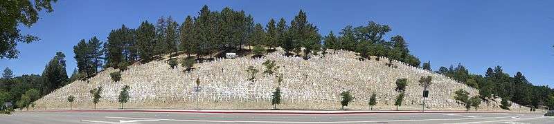
In November 2006, area residents began placing crosses on a hill overlooking the Lafayette BART station and Highway 24 "to represent and memorialize the American soldiers who have died in the ongoing Iraqi war." [24] As of January 2014, there are approximately 6,000 crosses in place, representing the troops who have died in Iraq, and there is also a large sign displaying the total number of deaths. The memorial has generated public attention, media coverage and counter-protests due to its visibility from the commuter thoroughfare below. Also, since the creation of the memorial, there have been several incidents of vandalism. While some show support for the protest, other residents complain that it is disrespectful to those in uniform in Iraq and that it is an eyesore to the community.[25]
Lafayette Park Theater
Another historical site found in Lafayette is the Park Theater, which first opened in 1941, and then ceased operations in 2005. The Park Theater was originally a movie theater located on an intersection where the La Fayette statue was built. It then showed its last movie before ceasing operations in 2005.[26] Recently; however, efforts have been made to reopen the Park theater for viewing.[27] A Facebook page called "Save Park Theater" was created to promote a potential reopening for the Park Theater.[28]
Education
Primary and secondary schools
- Public
- Lafayette Elementary School
- Burton Valley Elementary
- Happy Valley Elementary School
- Springhill Elementary School
- Stanley Middle School
- Acalanes High School
- Private
- Bentley School (Upper School Campus)
- The Springstone School (middle and high school)
- Chabad Hebrew School of Lamorinda
- St. Perpetua School
- The Meher Schools (preschool and elementary school)
Services
The Lafayette Library and Learning Center of the Contra Costa County Library is located in Lafayette.[29] Oakmont Memorial Park is a cemetery in Lafayette. Oakwood serves as a country club/fitness center for Lamorindans.
Notable people
The following is a list of notable residents of Lafayette, past and present.
Past
- Don Agrati, actor and musician, as Don Grady known for his roles in My Three Sons and The Mickey Mouse Club. Deceased.[30]
- Jon-Erik Beckjord, paranormal researcher and investigator, specialty was Bigfoot and related cryptids, such as the Yeti. Deceased.
- Matthew Brown, former professional football player for San Francisco 49ers.
- T. Brian Callister, MD, Lafayette native, physician, and nationally renowned health care quality and policy expert
- Frank DeVol, composer, arranger, conductor, singer ("Teddy Bear's Picnic"), on TV's Fernwood 2 Night as Happy Kyne. Died in Lafayette.
- Richard Ewell, former Confederate general who was a founder of Lafayette.
- Henry J. Kaiser, industrialist, owner of Kaiser Industries based in Oakland comprising more than 100 companies, builder of Hoover Dam, Liberty Ships, creator of Kaiser Permanente health organization. Built and lived in elaborate estate in west Lafayette in early 1950s.
- Joe Montana, Hall of Fame football quarterback for San Francisco 49ers and Kansas City Chiefs.
- Brent Mydland, musician, lived in Lafayette for a time before his death in 1990. buried at Oakmont Memorial Park in Lafayette.
- Josh Reddick, Major League Baseball outfielder for the Oakland Athletics
- Hideo Sasaki, American landscape architect.
- Glenn T. Seaborg, University of California at Berkeley chemist and Nobel laureate (1951) prominent in the discovery of Plutonium (in 1941) and several transuranic elements. Element 106, Seaborgium, is named in his honor. Worked on Manhattan Project developing first atomic bombs. Died in 1999.
- Emilio Segrè, an Italian physicist and Nobel laureate who discovered the elements technetium and astatine, and the antiproton, a sub-atomic antiparticle, for which he was awarded the Nobel Prize in Physics in 1959
- Alexander Shulgin, chemist best known for discovery and use of hundreds of psychoactive compounds. Died June 2, 2014.
- Karl Strauch (1922-2000), Harvard physicist and member of the U.S.-U.S.S.R. Joint Coordinating Committee on Fundamental Properties of Matter.
- Charles Tickner, Olympic bronze medalist figure skater in the 1980 Winter Olympics
Present
- Frankie Beverly, singer and songwriter, known primarily for his recordings with the band Maze.
- Cam (singer), Best known for the song "Burning House."
- Natalie Coughlin, gold medal-winning swimmer who represented United States at 2004 Olympics in Athens, 2008 Olympics in Beijing, and 2012 Olympics in London.
- Wayne Ferreira, South African tennis player.
- Hans Florine - world record-holding speed climber.
- Will Forte, actor, writer, and comedian best known for Saturday Night Live.
- Brad Gillis, musician, guitarist for band Nightranger.
- Daniel Horowitz, prominent attorney who was frequent TV commentator during the Scott Peterson trial.
- Buster Posey, professional baseball player for the San Francisco Giants.
- James Van Hoften, two-time space shuttle astronaut.
- Pamela Vitale, murdered in 2005 by Scott Dyleski.
- Mark Yudof - 21st President of University of California
- Andre Iguodala - Golden State Warriors basketball player, small forward.
See also
References
- ↑ "California Cities by Incorporation Date". California Association of Local Agency Formation Commissions. Archived from the original (Word) on November 3, 2014. Retrieved March 27, 2013.
- ↑ "City of Lafayette, CA: City Council". City of Lafayette, CA. Retrieved August 6, 2018.
- ↑ "Senators". State of California. Retrieved March 21, 2013.
- ↑ "Members Assembly". State of California. Retrieved March 21, 2013.
- ↑ "California's 11th Congressional District - Representatives & District Map". Civic Impulse, LLC. Retrieved March 9, 2013.
- ↑ "2016 U.S. Gazetteer Files". United States Census Bureau. Retrieved Jul 19, 2017.
- 1 2 "Population and Housing Unit Estimates". Retrieved June 9, 2017.
- 1 2 3 Durham, David L. (1998). California's Geographic Names: A Gazetteer of Historic and Modern Names of the State. Clovis, Calif.: Word Dancer Press. p. 649. ISBN 1-884995-14-4.
- 1 2 https://www.census.gov/quickfacts/fact/table/CA,lafayettecitycalifornia,US/PST045217
- ↑ Draft Environmental Impact Report for the East Area Service Center, Earth Metrics Incorporated, prepared for the East Bay Municipal Utility District, May, 1989
- ↑ Lafayette Historical Society: Town History Archived 2006-07-19 at the Wayback Machine.
- ↑ "Lafayette Historical Society Newsletter, January 2012" (PDF). Archived from the original (PDF) on 2013-12-02. Retrieved 2013-11-27.
- ↑ "Lafayette Historical Society Newsletter, March 2011" (PDF). Archived from the original (PDF) on 2013-12-02. Retrieved 2013-11-27.
- ↑ "Lafayette Historical Society Newsletter, October 2011" (PDF). Archived from the original (PDF) on 2013-12-02. Retrieved 2013-11-27.
- ↑ City of Lafayette - History of Lafayette Archived 2012-03-09 at the Wayback Machine.
- ↑ "Dedicated to the Pony Express Historical Marker". Retrieved 2017-09-22.
- ↑ U.S. Geological Survey Geographic Names Information System: Lafayette, California
- ↑ "Lafayette Historic Weather Averages in California (94549)". WSI Corporation. Retrieved 2013-06-07.
- ↑ WSI Corporation Retrieved 2013-06-07
- ↑ "Census of Population and Housing". Census.gov. Retrieved June 4, 2015.
- ↑ "2010 Census Interactive Population Search: CA - Lafayette city". U.S. Census Bureau. Retrieved July 12, 2014.
- ↑ "American FactFinder". United States Census Bureau. Retrieved 2008-01-31.
- ↑ http://elections.cdn.sos.ca.gov/ror/ror-pages/ror-odd-year-2017/politicalsub.pdf
- ↑ The Crosses of Lafayette: About
- ↑ San Francisco Chronicle: Grim Update to War Tally
- ↑ Article about closing
- ↑ Lamorinda weekly article
- ↑ Save Park Theater Facebook page
- ↑ "Lafayette Library." Contra Costa County Library. Retrieved on April 1, 2010.
- ↑ Janice De Jesus."Ex-Mouseketeer slated for Lesher performance: 'Robbie' from 'My Three Sons' will perform with lyricist Marty Panzer to benefit a nonprofit group for foster children," Walnut Creek Journal (CA), May 12, 2005, page 3.
External links
| Wikimedia Commons has media related to Lafayette, California. |
| Wikivoyage has a travel guide for Lafayette (California). |
- Official website

- Lafayette Chamber of Commerce
- Try Lafayette First: Lafayette Chamber's Blog
- Lafayette Library and Learning Center
- Sustainable Lafayette
| Bodies of water |
|  |
|---|---|---|
| Counties | ||
| Major cities | ||
| Cities and towns 100k–250k | ||
| Cities and towns 50k–99k | ||
| Cities and towns 25k-50k | ||
| Cities and towns 10k–25k |
| |
| Sub-regions | ||