El Cristo, Coclé
| El Cristo | |
|---|---|
| Town and corregimiento | |
 El Cristo | |
| Coordinates: 8°15′0″N 80°37′12″W / 8.25000°N 80.62000°WCoordinates: 8°15′0″N 80°37′12″W / 8.25000°N 80.62000°W | |
| Country |
|
| Province | Coclé |
| District | Aguadulce |
| Area[1] | |
| • Land | 113 km2 (44 sq mi) |
| Population (2010)[1] | |
| • Total | 4,017 |
| • Density | 35.5/km2 (92/sq mi) |
| Population density calculated based on land area. | |
| Time zone | UTC−5 (EST) |
El Cristo is a town and corregimiento in Aguadulce District, Coclé Province, Panama. It has a land area of 113 square kilometres (44 sq mi) and a population of 4,017 as of 2010, giving it a population density of 35.5 inhabitants per square kilometre (92/sq mi).[1] Its population as of 1990 was 3,393; its population as of 2000 was 3,852.[1]
El Cristo is one of the oldest towns in the region. In pre-Columbian times it was inhabited by an aboriginal community for a period of several centuries. According to studies by the archaeologist Cook, this community is similar to the pre-Columbian site of the Sierra at the edge of Santa Maria. The history of El Cristo goes back to the founding of Nata, by which time El Cristo was a cattle farm of the Spanish. The town is home to a Christmas tree, renowned for being the highest in Central America.
References
- 1 2 3 4 "Cuadro 11 (Superficie, población y densidad de población en la República...)" [Table 11 (Area, population, and population density in the Republic...)] {{webarchive |url=https://web.archive.org/web/20160304030354/http://www.contraloria.gob.pa/inec/archivos/P3601Cuadro11.xls |date=March 4, 2016 }} (.xls). In "Resultados Finales Básicos" [Basic Final Results] (in Spanish). National Institute of Statistics and Census of Panama. Archived from the original on July 10, 2015. Retrieved May 26, 2015.
Capital: Penonomé | ||
| Aguadulce | 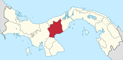 | |
| Antón | ||
| La Pintada |
| |
| Natá | ||
| Olá | ||
| Penonomé |
| |