El Caño
| El Caño | |
|---|---|
| Town and corregimiento | |
 El Caño | |
| Coordinates: 8°24′0″N 80°31′12″W / 8.40000°N 80.52000°WCoordinates: 8°24′0″N 80°31′12″W / 8.40000°N 80.52000°W | |
| Country |
|
| Province | Coclé |
| District | Natá |
| Area[1] | |
| • Land | 86 km2 (33 sq mi) |
| Population (2010)[1] | |
| • Total | 3,351 |
| • Density | 38.9/km2 (101/sq mi) |
| Population density calculated based on land area. | |
| Time zone | UTC−5 (EST) |
El Caño is a town and corregimiento in Natá District, Coclé Province, Panama. It has a land area of 86 square kilometres (33 sq mi) and had a population of 3,351 as of 2010, giving it a population density of 38.9 inhabitants per square kilometre (101/sq mi).[1] Its population as of 1990 was 2,936; its population as of 2000 was 3,276.[1]
El Caño is named after a nearby waterfall found in a creek whose waters end in a nearby river.
Capital: Penonomé | ||
| Aguadulce | 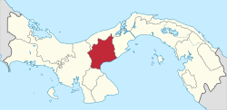 | |
| Antón | ||
| La Pintada |
| |
| Natá | ||
| Olá | ||
| Penonomé |
| |
References
- 1 2 3 4 "Cuadro 11 (Superficie, población y densidad de población en la República...)" [Table 11 (Area, population, and population density in the Republic...)] {{webarchive |url=https://web.archive.org/web/20160304030354/http://www.contraloria.gob.pa/inec/archivos/P3601Cuadro11.xls |date=March 4, 2016 }} (.xls). In "Resultados Finales Básicos" [Basic Final Results] (in Spanish). National Institute of Statistics and Census of Panama. Archived from the original on July 10, 2015. Retrieved May 26, 2015.
This article is issued from
Wikipedia.
The text is licensed under Creative Commons - Attribution - Sharealike.
Additional terms may apply for the media files.