L'Enfant Plaza station
L'Enfant Plaza | |||||||||||||||||||||||||||||||||||||||||||||||||
|---|---|---|---|---|---|---|---|---|---|---|---|---|---|---|---|---|---|---|---|---|---|---|---|---|---|---|---|---|---|---|---|---|---|---|---|---|---|---|---|---|---|---|---|---|---|---|---|---|---|
|
VRE commuter rail station ("L'Enfant") | |||||||||||||||||||||||||||||||||||||||||||||||||
 | |||||||||||||||||||||||||||||||||||||||||||||||||
| Location |
600 Maryland Avenue, Southwest Washington, D.C. 20024 690 Virginia Avenue SW (VRE) | ||||||||||||||||||||||||||||||||||||||||||||||||
| Owned by | Washington Metropolitan Area Transit Authority | ||||||||||||||||||||||||||||||||||||||||||||||||
| Line(s) |
| ||||||||||||||||||||||||||||||||||||||||||||||||
| Platforms |
2 side platforms (upper level) 1 island platform (lower level) | ||||||||||||||||||||||||||||||||||||||||||||||||
| Tracks | 4 (2 upper level, 2 lower level) | ||||||||||||||||||||||||||||||||||||||||||||||||
| Connections |
Eastern Market–L'Enfant Plaza | ||||||||||||||||||||||||||||||||||||||||||||||||
| Construction | |||||||||||||||||||||||||||||||||||||||||||||||||
| Structure type | Underground | ||||||||||||||||||||||||||||||||||||||||||||||||
| Depth |
98 feet (30 meters) Upper Level 118 feet (36 meters) Lower Level | ||||||||||||||||||||||||||||||||||||||||||||||||
| Platform levels | 2 | ||||||||||||||||||||||||||||||||||||||||||||||||
| Bicycle facilities | Yes | ||||||||||||||||||||||||||||||||||||||||||||||||
| Disabled access | Yes | ||||||||||||||||||||||||||||||||||||||||||||||||
| Other information | |||||||||||||||||||||||||||||||||||||||||||||||||
| Station code |
F03 (Metro upper level) D03 (Metro lower level) | ||||||||||||||||||||||||||||||||||||||||||||||||
| Fare zone | Zone 1 (VRE) | ||||||||||||||||||||||||||||||||||||||||||||||||
| History | |||||||||||||||||||||||||||||||||||||||||||||||||
| Opened |
July 1, 1977 (WMATA) June 1992[1][2] (VRE) | ||||||||||||||||||||||||||||||||||||||||||||||||
| Traffic | |||||||||||||||||||||||||||||||||||||||||||||||||
| Passengers (2017) |
20,235 daily [3] | ||||||||||||||||||||||||||||||||||||||||||||||||
| Services | |||||||||||||||||||||||||||||||||||||||||||||||||
| |||||||||||||||||||||||||||||||||||||||||||||||||
L'Enfant Plaza is a Washington Metro station in the Southwest Federal Center neighborhood of Washington, D.C. The station was opened on July 1, 1977, and is operated by the Washington Metropolitan Area Transit Authority (WMATA). It is a transfer station with two levels: the upper level has two side platforms and is used by the Green and Yellow Lines, while the lower level has an island platform used by the Blue, Orange, and Silver Lines.[4] It is also where the Yellow and Green lines converge going north. The station serves five out of the system's six lines, serving the most lines out of any station in the system; only the Red Line does not serve the station. L'Enfant Plaza is the deepest on the Green and Yellow Lines at a depth of 98 feet (30 meters) below ground level. It is the second deepest on the Blue, Orange, and Silver Lines behind Rosslyn at a depth of 118 feet (36 meters) below ground level.
L'Enfant Plaza is the last station in the District on the Yellow Line before crossing the Potomac into Virginia on the 14th Street Bridge.
Description
Location
The station is located in Southwest Washington, with entrances at the L'Enfant Plaza shopping mall concourse at 9th and D Streets, on D Street between 6th and 7th Streets, and at Maryland Avenue and 7th Street. It is in the center of an area crowded with federal buildings and is a transfer point allowing passengers to easily cross the Potomac between Virginia and central Washington, making it a very busy station. L'Enfant Plaza is named for the French-American planner of Washington, D.C., Pierre L'Enfant.[5]
VRE station
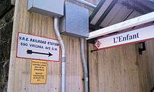
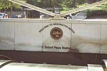
Directly above the Metro station, on Virginia Avenue between 6th and 7th Streets, is the Virginia Railway Express L'Enfant station, which provides commuter rail service both to Fredericksburg and to Manassas Regional Airport in Bristow. Numerous Amtrak trains pass through this station, most without stopping. There is one side platform on the north side of the station with 3 tracks passing through.[6] There are walkways on each side of the station that lead to 6th and 7th Streets respectively.[6]
History
The station opened on July 1, 1977.[7] Its opening coincided with the completion of 11.8 miles (19.0 km)[8] of rail between National Airport and RFK Stadium and the opening of the Arlington Cemetery, Capitol South, Crystal City, Eastern Market, Farragut West, Federal Center SW, Federal Triangle, Foggy Bottom–GWU, McPherson Square, National Airport, Pentagon, Pentagon City, Potomac Avenue, Rosslyn, Smithsonian and Stadium–Armory stations.[9] Orange Line service to the station began upon the line's opening on November 20, 1978;[10] Yellow Line service to the station began upon the line's opening on April 30, 1983;[11] Green Line service to the station began upon the line's opening on May 11, 1991;[12] and Silver Line service to the station began upon the line's opening on July 26, 2014.[13] This makes the station unique in that the lower level island platform opened before the upper level side platforms.
L'Enfant Plaza was the setting of a 2007 Pulitzer Prize winning article by Washington Post reporter Gene Weingarten. World-famous classical violinist Joshua Bell performed outside the station at rush hour disguised as a street musician. Only seven people stopped to watch him for a minute or more. In total, he made $52.47 performing for 45 minutes, including $20 from the one person who recognized him. Three days earlier, Bell had performed at a concert in Boston where seats started at $100.[14]
On January 12, 2015, smoke began appearing in the station which suspended service at L'Enfant Plaza during the afternoon rush hour. The smoke caused 1 death and 84 people were treated at local hospitals. Green Line and Yellow Line trains were temporarily suspended while Blue Line, Orange Line, and Silver Line trains bypassed L'Enfant Plaza and continued normal service.[15]
Special elevator conditions
All platforms at the L'Enfant Plaza station are wheelchair-accessible. However, there is only one elevator on the lower level: on its upper floor, it is only able to access the southbound Green and Yellow Lines. This means a wheelchair passenger or other person who cannot use an escalator or must use an elevator, and needs to transfer from the Blue, Orange, or Silver Lines to the northbound Green or Yellow Lines, must take the elevator to the southbound Yellow/Green Lines, continue around the platform to the elevator up to the mezzanine, cross around to the other elevator, then proceed down to the northbound Green and Yellow Lines.
Conversely, a passenger on a northbound Yellow or Green Line train who must use an elevator and wants to transfer to a Blue, Orange, or Silver Line train, must take an elevator up to the mezzanine, go around to the elevator to the southbound platform, take that elevator down to the opposite track, go around to the other elevator and then proceed down to the lower level.
Station layout
| G | Street level | Exit/entrance |
| B1 VRE platforms |
WMATA mezzanine | Fare control and station agent |
| Side platform, doors will open on the left, right | ||
| Track 1 | ← Manassas Line toward Broad Run (Crystal City) ← Fredericksburg Line toward Spotsylvania (Crystal City) Manassas and Fredericksburg Lines toward Union Station (Terminus) → ← Amtrak and Manassas Line (select trains) do not stop here → | |
| Track 2 | ← Amtrak and Manassas Line (select trains) do not stop here → | |
| Track 3 | ← Amtrak and Manassas Line (select trains) do not stop here → | |
| B2 Green/Yellow Line platforms |
Side platform, doors will open on the right | |
| Northbound | ← ← | |
| Southbound | → | |
| Side platform, doors will open on the right | ||
| B3 Blue/Orange/Silver Line platforms |
Westbound | ← ← ← |
| Island platform, doors will open on the left | ||
| Eastbound | → → | |
Gallery
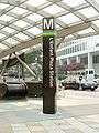 Station entrance pylon in 2004. A stripe for the Silver Line has since been added.
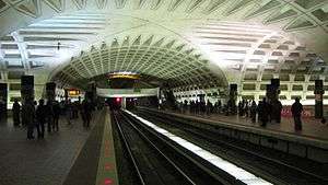
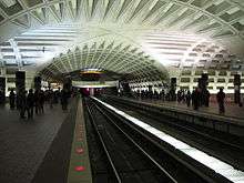 Crossvault on the ceiling of the upper level of the station
Notable nearby locations
- L'Enfant Plaza
- National Mall
- District of Columbia Department of Motor Vehicles, Adjudication Services
- Several Smithsonian Institution museums, including:
- Arts and Industries Building (currently closed)
- Hirshhorn Museum and Sculpture Garden
- National Air and Space Museum (nearest Smithsonian museum to station)
- Several federal government buildings, including:
References
- ↑ Masters, Brooke A. (April 4, 1991). "Red Tape May Delay Va. Commuter Rail". Washington Post.
- ↑ Fehr, Stephen C. (June 18, 1992). "Getting on Track". Washington Post.
- ↑ "Metrorail Average Weekday Passenger Boardings" (PDF). WMATA. Retrieved July 31, 2018.
- ↑ Metropolitan Washington Airports Authority (2010). "Dulles Metrorail Project Overview". Archived from the original on July 27, 2010. Retrieved July 25, 2010.
- ↑ L'Enfant identified himself as "Peter Charles L'Enfant" during most of his life, while residing in the United States. He wrote this name on his "Plan of the city intended for the permanent seat of the government of t(he) United States ...." (Washington, D.C.) and on other legal documents. However, during the early 1900s, a French ambassador to the U.S., Jean Jules Jusserand, popularized the use of L'Enfant's birth name, "Pierre Charles L'Enfant". (Reference: Bowling, Kenneth R (2002). Peter Charles L'Enfant: vision, honor, and male friendship in the early American Republic. George Washington University, Washington, D.C. ISBN 978-0-9727611-0-9). The United States Code states in 40 U.S.C. 3309: "(a) In General.—The purposes of this chapter shall be carried out in the District of Columbia as nearly as may be practicable in harmony with the plan of Peter Charles L'Enfant." The National Park Service identifies L'Enfant as Major Peter Charles L'Enfant and as Major Pierre (Peter) Charles L'Enfant on its website.
- 1 2 Google (December 19, 2010). "L'Enfant Plaza station" (Map). Google Maps. Google. Retrieved December 19, 2010.
- ↑ Feaver, Douglas B. (July 1, 1977), "Today, Metro could be U.S. model", The Washington Post, p. A1
- ↑ Washington Metropolitan Area Transit Authority (July 2009). "Sequence of Metrorail openings" (PDF). Archived from the original (PDF) on January 13, 2010. Retrieved July 25, 2010.
- ↑ Staff Reporters (June 24, 1977), "Metro's newest stations: Where they are, what's nearby", The Washington Post
- ↑ Eisen, Jack; John Feinstein (November 18, 1978), "City-County fanfare opens Orange Line; Ceremonies open new Orange Line", The Washington Post, p. D1
- ↑ Lynton, Stephen J. (April 25, 1983), "Trans-Potomac subway segment to open Saturday", The Washington Post, p. B1
- ↑ Fehr, Stephen C. (May 5, 1991), "Going was tough, but Green gets going", The Washington Post, p. D1
- ↑ "All aboard! Metro's new Silver Line rolls down the tracks for the first time". Washington Post.
- ↑ Pearls Before Breakfast: Can one of the nation’s great musicians cut through the fog of a D.C. rush hour? Let’s find out.
- ↑ Zauzmer, Julie; Duggan, Paul; Hermann, Peter (January 12, 2015), "One dead after smoke fills Metro station, forcing evacuation", washingtonpost.com, Washington, DC: The Washington Post, retrieved January 13, 2015
External links
| Wikimedia Commons has media related to L'Enfant Plaza (WMATA station). |
- WMATA: L'Enfant Plaza Station
- StationMasters Online: L'Enfant Plaza Station
- VRE: L'Enfant Plaza Station
- D Street and 9th Street entrance from Google Maps Street View
- D Street, between 6th and 7th Streets, from Google Maps Street View
- Maryland Avenue and 7th Street entrance from Google Maps Street View
- 6th Street entrance from Google Maps Street View
- 7th Street entrance from Google Maps Street View
Coordinates: 38°53′05″N 77°01′19″W / 38.884775°N 77.021964°W