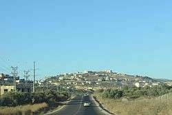
Jamma'in
| Jammain | |
|---|---|
| Other transcription(s) | |
| • Arabic | جمّاعين |
| • Also spelled |
Jamma'in (official) Jamma'een (unofficial) |
 Jammain | |
 Jammain Location of Jammain within Palestine | |
| Coordinates: 32°07′52″N 35°12′03″E / 32.13111°N 35.20083°ECoordinates: 32°07′52″N 35°12′03″E / 32.13111°N 35.20083°E | |
| Palestine grid | 169/170 |
| Governorate | Nablus |
| Government | |
| • Type | Municipality |
| • Head of Municipality | 'Izzat Zeitawi |
| Area | |
| • Jurisdiction | 19,821 dunams (19.8 km2 or 7.6 sq mi) |
| Population (2007) | |
| • Jurisdiction | 6,225 |
| Name meaning | "Company"[1] |
Jamma'in (Arabic: جمّاعين) is a Palestinian town in the northern West Bank located 16 kilometers (9.9 mi) southwest of Nablus, 6 kilometers (3.7 mi) northwest of Salfit and 40 kilometers (25 mi) north of Ramallah. According to the Palestinian Central Bureau of Statistics, the town had a population of 6,227 in 2007.[2]
Location
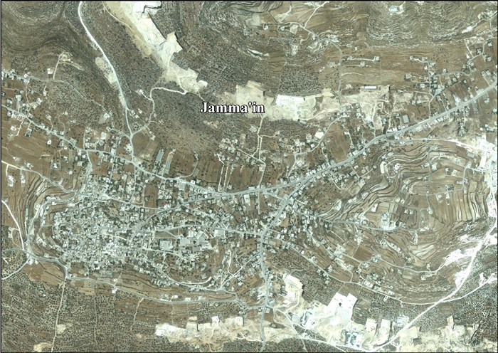
Jamma’in is located 11.26 km south of Nablus. It is bordered by 'Einabus and Huwwara to the east, Yasuf, Iskaka and Marda to the south, Zeita Jamma'in to the west, 'Asira al Qibliya and 'Urif to the north.[3]
History
Jamma'in is situated on a high hill on the ancient site. Carved stones have been reused in village houses, walls, fencing and agricultural terraces. Rock-cut cisterns have also been found. 400 meters north-west are tombs carved into rock which contains one loculi and caves (called I-Qubay'ah).[4]
Sherds from the Iron Age I, IAII, Persian, Hellenistic,[5] Roman[4][5] and Byzantine eras have also been found here.[4][5]
Middle Ages
A village in the Crusader era (1123 CE) named "Gemmail",[6] has been identified with Jamma'in.[5] It was referred to as "Jamma'il" in medieval Arabic sources. The village was home to the Bani Qudama clan, who moved to Damascus in 1156, during Crusader rule in Palestine.[7] Their leader, and the khatib (Muslim preacher) of the village, Ahmad ibn Qudama (father of Ibn Qudamah and grandfather of Diya al-Din), left Jamma'in due to fears of persecution by King Baldwin, who intended to punish Ibn Qudamah for preaching against Crusader rule.[8] The hilly and uninhabited area of Damascus the Banu Qudamah settled became the al-Salihiyah suburb,[7] which was named either after the family, who were known as "the pious ones" (as-salihiyyin) or after the Abi Salih Mosque, which the family was associated with.[9] Throughout the 11th and 12th centuries, Jamma'in was a center for Hanbali activity.[5] The medieval Syrian geographer Yaqut (1179–1229) described the site as "A well in the hill of Nabulus, in the Filastin Province. It lies a day's journey distant from Jerusalem, and belongs to that city."[5][10] Diya al-Din (1173-1245) refers to the presence of Muslims in Jamma'in during his lifetime, and he also noted that the village had a mosque.[11]
Crusader/Ayyubid and Mamluk sherds have also been found here.
Ottoman era
Jamma'in was incorporated into the Ottoman Empire in 1517 with all of Palestine, and in 1596 it appeared in the tax registers as being in the nahiya of Jabal Qubal in the liwa of Nablus. It had an entirely Muslim population of eighteen households and five bachelors. The inhabitants of the village paid a fixed tax rate of 33,3% on wheat, barley, summer crops, olive trees, goats and/or beehives, and a press for grapes or olives; a total of 7,800 akçe.[12]
In the 17th century, the Qasim family ruled Jamma'in and twenty nearby villages, including Awarta, Beit Wazan, Haris and Zeita. Jamma'in was the seat of the Jamma'in subdistrict of the District of Nablus. In 1834, when the Egyptians under Ibrahim Pasha ruled Palestine, Ottoman-aligned Arab families in Palestine revolted under the leadership of Qasim al-Ahmad. The revolt, however, was crushed, and Qasim and his two eldest sons were hanged.[13][14] The Zeitawi tribe migrated to the town from nearby Zeita (from which the family received its name) in the 18th century.[15]
In 1838, Edward Robinson noted it as a village, Jemma'in, in the Jurat Merda district, south of Nablus.[16]
The French explorer Victor Guérin visited the village in 1870, and he estimated it had 1,400 inhabitants. The houses were better built than many other places in Palestine, and some seemed newly rebuilt.[17] In 1882, the Palestine Exploration Fund's Survey of Western Palestine (SWP) described Jamma'in as "the largest village in the district, on high ground, surrounded with olive groves. The water supply is from a pool and a well east of the village."[18]
British Mandate era
In the 1922 census of Palestine, conducted by the British Mandate authorities, Jamma'in had a population of 720, all Muslims,[19] increasing in the 1931 census to 957, still all Muslims, living in 202 houses.[20]
In the 1945 statistics, Jamma'in had a population of 1,240, all Muslims,[21] with 19,821 dunams of land, according to an official land and population survey.[22] Of this, 5,362 dunams were plantations and irrigable land, 6,625 used for cereals,[23] while 77 dunams were built-up land.[24]
Jordanian era
In the wake of the 1948 Arab–Israeli War, and after the 1949 Armistice Agreements, Jamma'in came under Jordanian rule.
In 1961, the population was 1,965.[25]
Post-1967
After the Six-Day War in 1967, Jamma'in has been under Israeli occupation. Like many other Palestinian localities in the West Bank, Jamma'in's residents have been involved in the Israeli–Palestinian conflict, and have been a target of several raids by the Israel Defense Forces (IDF). Since the First Intifada in 1987, six people from the town have been killed by the IDF and hundreds of its residents have been imprisoned.
In January 2015 Israel forces set up an iron gate at the southern entrance to the village, its main exit point, blocking transit between Jamma'in and Marda. IDF soldiers deny entry to Palestinian citizens travelling in either direction. According to PA no explanation was given for the sudden move.[26]
According to ARIJ, 77% of the village land is in Area B, while the remaining 23% is in Area C.[27]
Demographics
In the 1997 census by the Palestinian Central Bureau of Statistics (PCBS), Jaba' had a population of 4,311. Palestinian refugees accounted for 3.9% of the inhabitants.[28] In the 2007 PCBS census, the population grew to 6,225, living in 1,010 households with each household containing an average of six members. There were 1,170 housing units. The gender ratio was 49.1% female and 50.9% male.[2]
Economy
The two most prominent economic sectors of Jamma'in is stone-cutting and agriculture. Since the Second Intifada, the stone-cutting industry has grown weaker due to the cost of electricity increasing and the cost of stone, to Israel and Jordan, has decreased. Some people work in Palestinian government offices in Ramallah. Basket-weaving is not a major economic sector, but along with Zeita and az-Zawiya, Jamma'in is well known for producing baskets made from olive wood fronds.[29]
Olives are the primary crop grown. There are two or three sheep and cow farms in Jamma'in. Milk, yogurt and cheese are sold in the town. There are two mosques, a religious charity and a library in the town. There are five schools in Jamma'in; Two boys' schools, two girls' schools and co-ed school. Over 90% of the population over the age of 10 is literate. Most university students attend the an-Najah National University.
Government
Jamma'in is governed by a municipal council of eleven members, including one reserved for females. In the 2005 Palestinian municipal elections, the Hamas-backed Al-Islamiya for Reform list won seven seats, the majority, and the Fatah-backed Martyrs list won three seats and an Independent list won the remaining seat. Female candidates won two seats.[30] 'Izzat Mahmoud Zeitawi succeeded Ahmad Mahmoud Zeitawi as head of the municipality of Jamma'in.
References
- ↑ Palmer, 1881, p. 229
- 1 2 2007 PCBS Census Archived 2010-12-10 at the Wayback Machine.. Palestinian Central Bureau of Statistics. p.110.
- ↑ Jamma'in Town Profile, ARIJ, p. 4
- 1 2 3 Dauphin, 1998, p. 807
- 1 2 3 4 5 6 Finkelstein and Lederman, 1997, p. 506
- ↑ Röhricht, 1893, RHH, p. 23, #101.
- 1 2 Meri, 2002, p. 136
- ↑ Talmon-Heller, Daniela (2007). Islamic Piety in Medieval Syria: Mosques, Cemeteries and Sermons Under the Zangids and Ayyubids (1146–1260). Brill. p. 96.
- ↑ Akkach, Samer (2007). 'Abd Al-Ghani Al-Nabulusi: Islam and the Enlightenment. Oneworld. p. 21.
- ↑ Le Strange, 1890, p. 462
- ↑ Ellenblum, 2003, p. 244
- ↑ Hütteroth and Abdulfattah, 1977, p. 133
- ↑ Doumani, 1995, Rediscovering Palestine: Egyptian rule, 1831-1840
- ↑ Macalister and Masterman, 1905, p. 355
- ↑ "Jamma'in Village Profile" (PDF). OCHA. 2008-08-20.
- ↑ Robinson and Smith, 1841, vol 3, Appendix 2, p. 127
- ↑ Guérin, 1875, pp. 172-3
- ↑ Conder and Kitchener, 1882, SWP II, p. 284
- ↑ Barron, 1923, Table IX, Sub-district of Nablus, p. 25
- ↑ Mills, 1932, p. 62.
- ↑ Government of Palestine, Department of Statistics, 1945, p. 18
- ↑ Government of Palestine, Department of Statistics. Village Statistics, April, 1945. Quoted in Hadawi, 1970, p. 60
- ↑ Government of Palestine, Department of Statistics. Village Statistics, April, 1945. Quoted in Hadawi, 1970, p. 106
- ↑ Government of Palestine, Department of Statistics. Village Statistics, April, 1945. Quoted in Hadawi, 1970, p. 156
- ↑ Government of Jordan, Department of Statistics, 1964, p. 26
- ↑ 'Israeli forces install iron gate at entrance to Nablus-area village,' Ma'an News Agency 7 January 2015
- ↑ Jamma'in Town Profile, ARIJ, p. 15
- ↑ "Palestinian Population by Locality and Refugee Status". Archived from the original on November 14, 2011. Retrieved 2008-04-24. . 1997 Census. Palestinian Central Bureau of Statistics (PCBS). 1999.
- ↑ PACE’s Exhibit of Traditional Palestinian Handicrafts Palestinian Association for Cultural Exchange.
- ↑ Local Elections (Round two)- Successful candidates by local authority, gender and No. of votes obtained Central Elections Commission - Palestine, p.11.
Bibliography
- Barron, J.B., ed. (1923). Palestine: Report and General Abstracts of the Census of 1922. Government of Palestine.
- Conder, C.R.; Kitchener, H.H. (1882). The Survey of Western Palestine: Memoirs of the Topography, Orography, Hydrography, and Archaeology. 2. London: Committee of the Palestine Exploration Fund.
- Dauphin, Claudine (1998). La Palestine byzantine, Peuplement et Populations. BAR International Series 726 (in French). III : Catalogue. Oxford: Archeopress. ISBN 0-860549-05-4.
- Doumani, B. (1995). Rediscovering Palestine: Merchants and Peasants in Jabal Nablus. University of California Press.
- Drory, Joseph (1988). "Hanbalis of the Nablus Region in the Eleventh and Twelfth Centuries". Asian and African Studies. 22: 93–112.
- Ellenblum, Ronnie (2003). Frankish Rural Settlement in the Latin Kingdom of Jerusalem. Cambridge University Press. ISBN 9780521521871.
- Finkelstein, I.; Lederman, Zvi, eds. (1997). Highlands of many cultures. Tel Aviv: Institute of Archaeology of Tel Aviv University Publications Section. ISBN 965-440-007-3.
- Government of Jordan, Department of Statistics (1964). First Census of Population and Housing. Volume I: Final Tables; General Characteristics of the Population (PDF).
- Government of Palestine, Department of Statistics (1945). Village Statistics, April, 1945.
- Guérin, V. (1875). Description Géographique Historique et Archéologique de la Palestine (in French). 2: Samarie, pt. 2. Paris: L'Imprimerie Nationale.
- Hadawi, S. (1970). Village Statistics of 1945: A Classification of Land and Area ownership in Palestine. Palestine Liberation Organization Research Center.
- Hütteroth, Wolf-Dieter; Abdulfattah, Kamal (1977). Historical Geography of Palestine, Transjordan and Southern Syria in the Late 16th Century. Erlanger Geographische Arbeiten, Sonderband 5. Erlangen, Germany: Vorstand der Fränkischen Geographischen Gesellschaft. ISBN 3-920405-41-2.
- Macalister, R.A. Stewart; Masterman, E. W. G. (1905). "Occasional Papers on the Modern inhabitants of Palestine, part I & part II". Quarterly statement - Palestine Exploration Fund. 37: 343–356.
- Meri, J.W. (2002). The Cult of Saints among Muslims and Jews in Medieval Syria. Oxford University Press.
- Mills, E., ed. (1932). Census of Palestine 1931. Population of Villages, Towns and Administrative Areas. Jerusalem: Government of Palestine.
- Palmer, E.H. (1881). The Survey of Western Palestine: Arabic and English Name Lists Collected During the Survey by Lieutenants Conder and Kitchener, R. E. Transliterated and Explained by E.H. Palmer. Committee of the Palestine Exploration Fund.
- Robinson, E.; Smith, E. (1841). Biblical Researches in Palestine, Mount Sinai and Arabia Petraea: A Journal of Travels in the year 1838. 3. Boston: Crocker & Brewster.
- Röhricht, R. (1893). (RRH) Regesta regni Hierosolymitani (MXCVII-MCCXCI) (in Latin). Berlin: Libraria Academica Wageriana.
- Strange, le, G. (1890). Palestine Under the Moslems: A Description of Syria and the Holy Land from A.D. 650 to 1500. Committee of the Palestine Exploration Fund.
- Talmon-Heller, Daniella (1994). "Popular Hanbalite Islam in 12th-13th Century Jabal Nablus and Jabal Qasyūn". Studia Islamica. 79: 103–120.
- Talmon-Heller, Daniella (2002). Riley-Smith, J., ed. The Cited Tales of the Wondrous Doings of the Shaykhs of the Holy Land. 1. published in Crusades. Aldershot, Hampshire: Published by Ashgate for the Society for the Study of the Crusades and the Latin East. pp. 111–154. ISBN 0754609189.
External links
- Welcome to Jamma'in
- Jamma’in, Welcome to Palestine
- Survey of Western Palestine, Map 14: IAA, Wikimedia commons
- Jamma'in Town Profile, Applied Research Institute–Jerusalem (ARIJ)
- Jamma'in (aerial photo), ARIJ
- Jamma'in Village Profile
