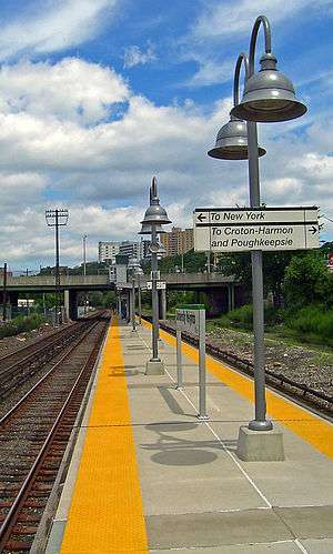
University Heights station
University Heights | |||||||||||||||||||||||||||||||
|---|---|---|---|---|---|---|---|---|---|---|---|---|---|---|---|---|---|---|---|---|---|---|---|---|---|---|---|---|---|---|---|
 The University Heights Metro-North station, on the Hudson Line. | |||||||||||||||||||||||||||||||
| Location |
West Fordham Road at the Major Deegan Expressway University Heights, Bronx, New York | ||||||||||||||||||||||||||||||
| Coordinates | 40°51′41″N 73°54′53″W / 40.8614°N 73.9147°WCoordinates: 40°51′41″N 73°54′53″W / 40.8614°N 73.9147°W | ||||||||||||||||||||||||||||||
| Owned by | Metro-North Railroad | ||||||||||||||||||||||||||||||
| Line(s) | |||||||||||||||||||||||||||||||
| Platforms | 1 island platform | ||||||||||||||||||||||||||||||
| Tracks | 3 | ||||||||||||||||||||||||||||||
| Connections |
| ||||||||||||||||||||||||||||||
| Other information | |||||||||||||||||||||||||||||||
| Fare zone | 2 | ||||||||||||||||||||||||||||||
| Electrified | 700V (DC) third rail | ||||||||||||||||||||||||||||||
| Traffic | |||||||||||||||||||||||||||||||
| Passengers (2006) |
5,720 | ||||||||||||||||||||||||||||||
| Services | |||||||||||||||||||||||||||||||
| |||||||||||||||||||||||||||||||
The University Heights (also known as University Heights – West 207th Street) Metro-North Railroad station serves residents of the University Heights neighborhood of the Bronx, New York City, via the Hudson Line. Trains leave for Manhattan every 25 to 35 minutes on weekdays. It is 8.69 miles (13.99 km) from Grand Central Terminal, and travel time to Grand Central is approximately 19 minutes.
It is located between the Harlem River and the Major Deegan Expressway. Access to the platform is via a staircase from the pedestrian walkway on the south side of University Heights Bridge. It is also near the Roberto Clemente State Park.
History
The station has operated since the days of the Spuyten Duyvil and Port Morris Railroad as well as the New York and Putnam Railroad late in the 19th century, though not in its present form. It was originally located north of the former 180th Street (now Osbourne Place), while a nearby Fordham Heights station was located at West Fordham Road.[1] At some point before the 1920s, the two stations were merged, although demolition of the Fordham Heights Station was being planned as early as 1906.[2] North of Fordham Road, the former NY&P branched off to the northeast on its way to Brewster.
Throughout much of the 20th Century, University Heights station contained a station house over the tracks along the south side of West Fordham Road. As with many NYCRR stations in the Bronx, the station became a Penn Central station upon the merger between NYC and Pennsylvania Railroad in 1968. Penn Central continued commuter service and began tearing the station house down in 1975,[3] before until it was taken over by Conrail in 1976, which turned the station over to Metro-North Railroad in 1983.
Station layout
This station has one high-level island platform accessible by stairway or elevator from West Fordham Road. The platform is four cars long; when trains stop at this station, only four cars receive and discharge passengers.
| G | Street level | Exit/entrance |
| P Platform level |
Track 4 | ← Hudson Line express trains do not stop here |
| Track 2 | ← Hudson Line toward Grand Central (Morris Heights) | |
| Island platform, doors will open on the left or right | ||
| Track 1 | Hudson Line toward Croton–Harmon or Poughkeepsie (Marble Hill) → Hudson Line express trains do not stop here → | |
References
- ↑ BotMultichill (1899). 1899 Home Life Map of New York City ( Manhattan and the Bronx ) - Geographicus - NYC-HomeLife-1899.jpg (map). Retrieved October 18, 2014 – via WikiMedia Commons.
- ↑ Board of Railroad Commissioners of the State of New York. "Twenty-fourth Annual report of the Board of Railroad Commissioners of the State of New York". J.B. Lyon, State Printer, 1907.
- ↑ Kenneth Palter photograph of University Heights PCRR station in April 1975 (WorldNYCSubway.org)
_-_Geographicus_-_NYC-HomeLife-1899.jpg)