Hudson Line (Metro-North)
| Hudson Line | |||||||||||||||||||||||||||||||||||||||||||||||||||||||||||||||||||||||||||||||||||||||||||||||||||||||||||||||||||||||||||||||||||||||||||||||||||||||||||||||||||||||||||||||||||||||||||||||||||||||||||||||||||||||||||||||||||||||||||||||||||||||||||||||||||||||||||||||||||||||||||||||||||||||||||||||||||||||||||||||||||||||||||||||||||||||||||||||||||||||||||||||||||||||||||||||||||||||||||||||||||||||||||||||||||||||||||||||||||||||||||||||||||||||||||||||||||||||||||||||||||||||||||||||||||||||||||||||||||||||||||||||||||||||||||||||||||||||||||||||||||||||||||||||||||||||||||||||||||||||||||||||||||||||||||||||||||||||||||||||||||||||||||||||||||||||||||||||||||||||||||||||||||||||||||||||||||||||||||||||||||||||||||||||||||||||||||||||||||||||||||||||||||||||||||||||||||||||||||||||||||||||||||||||||||||||||||||||||||||||||||||||||||||||||||
|---|---|---|---|---|---|---|---|---|---|---|---|---|---|---|---|---|---|---|---|---|---|---|---|---|---|---|---|---|---|---|---|---|---|---|---|---|---|---|---|---|---|---|---|---|---|---|---|---|---|---|---|---|---|---|---|---|---|---|---|---|---|---|---|---|---|---|---|---|---|---|---|---|---|---|---|---|---|---|---|---|---|---|---|---|---|---|---|---|---|---|---|---|---|---|---|---|---|---|---|---|---|---|---|---|---|---|---|---|---|---|---|---|---|---|---|---|---|---|---|---|---|---|---|---|---|---|---|---|---|---|---|---|---|---|---|---|---|---|---|---|---|---|---|---|---|---|---|---|---|---|---|---|---|---|---|---|---|---|---|---|---|---|---|---|---|---|---|---|---|---|---|---|---|---|---|---|---|---|---|---|---|---|---|---|---|---|---|---|---|---|---|---|---|---|---|---|---|---|---|---|---|---|---|---|---|---|---|---|---|---|---|---|---|---|---|---|---|---|---|---|---|---|---|---|---|---|---|---|---|---|---|---|---|---|---|---|---|---|---|---|---|---|---|---|---|---|---|---|---|---|---|---|---|---|---|---|---|---|---|---|---|---|---|---|---|---|---|---|---|---|---|---|---|---|---|---|---|---|---|---|---|---|---|---|---|---|---|---|---|---|---|---|---|---|---|---|---|---|---|---|---|---|---|---|---|---|---|---|---|---|---|---|---|---|---|---|---|---|---|---|---|---|---|---|---|---|---|---|---|---|---|---|---|---|---|---|---|---|---|---|---|---|---|---|---|---|---|---|---|---|---|---|---|---|---|---|---|---|---|---|---|---|---|---|---|---|---|---|---|---|---|---|---|---|---|---|---|---|---|---|---|---|---|---|---|---|---|---|---|---|---|---|---|---|---|---|---|---|---|---|---|---|---|---|---|---|---|---|---|---|---|---|---|---|---|---|---|---|---|---|---|---|---|---|---|---|---|---|---|---|---|---|---|---|---|---|---|---|---|---|---|---|---|---|---|---|---|---|---|---|---|---|---|---|---|---|---|---|---|---|---|---|---|---|---|---|---|---|---|---|---|---|---|---|---|---|---|---|---|---|---|---|---|---|---|---|---|---|---|---|---|---|---|---|---|---|---|---|---|---|---|---|---|---|---|---|---|---|---|---|---|---|---|---|---|---|---|---|---|---|---|---|---|---|---|---|---|---|---|---|---|---|---|---|---|---|---|---|---|---|---|---|---|---|---|---|---|---|---|---|---|---|---|---|---|---|---|---|---|---|---|---|---|---|---|---|---|---|---|---|---|---|---|---|---|---|---|---|---|---|---|---|---|---|---|---|---|---|---|---|---|---|---|---|---|---|---|---|---|---|---|---|---|---|---|---|---|---|---|---|---|---|---|---|---|---|---|---|---|---|---|---|---|---|---|---|---|---|---|---|---|---|---|---|---|---|---|---|---|---|---|---|---|---|---|---|---|---|---|---|---|---|---|---|---|---|---|---|---|---|---|---|---|---|---|---|---|---|---|---|---|---|---|---|---|---|---|---|---|---|---|---|---|---|---|---|---|---|---|---|---|---|---|---|---|---|---|---|---|---|---|---|---|---|---|---|---|---|---|---|---|---|---|---|---|---|---|---|---|---|---|---|---|---|---|---|---|---|---|---|---|---|---|---|---|---|---|---|---|---|---|---|---|---|---|---|---|---|---|---|---|---|---|---|---|---|---|---|---|---|---|---|---|---|---|---|---|---|---|---|---|---|---|---|---|---|---|---|---|---|---|---|---|---|---|---|---|---|---|---|---|---|---|---|---|---|---|---|---|---|---|---|---|---|---|---|---|---|---|---|---|---|---|---|---|---|---|---|---|---|---|---|---|---|---|---|---|---|---|---|---|---|---|---|---|---|---|---|---|---|---|---|---|---|---|---|---|---|---|---|---|---|---|---|---|---|---|---|---|
|
| |||||||||||||||||||||||||||||||||||||||||||||||||||||||||||||||||||||||||||||||||||||||||||||||||||||||||||||||||||||||||||||||||||||||||||||||||||||||||||||||||||||||||||||||||||||||||||||||||||||||||||||||||||||||||||||||||||||||||||||||||||||||||||||||||||||||||||||||||||||||||||||||||||||||||||||||||||||||||||||||||||||||||||||||||||||||||||||||||||||||||||||||||||||||||||||||||||||||||||||||||||||||||||||||||||||||||||||||||||||||||||||||||||||||||||||||||||||||||||||||||||||||||||||||||||||||||||||||||||||||||||||||||||||||||||||||||||||||||||||||||||||||||||||||||||||||||||||||||||||||||||||||||||||||||||||||||||||||||||||||||||||||||||||||||||||||||||||||||||||||||||||||||||||||||||||||||||||||||||||||||||||||||||||||||||||||||||||||||||||||||||||||||||||||||||||||||||||||||||||||||||||||||||||||||||||||||||||||||||||||||||||||||||||||||||
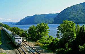 A northbound Hudson Line train passing the Hudson Highlands | |||||||||||||||||||||||||||||||||||||||||||||||||||||||||||||||||||||||||||||||||||||||||||||||||||||||||||||||||||||||||||||||||||||||||||||||||||||||||||||||||||||||||||||||||||||||||||||||||||||||||||||||||||||||||||||||||||||||||||||||||||||||||||||||||||||||||||||||||||||||||||||||||||||||||||||||||||||||||||||||||||||||||||||||||||||||||||||||||||||||||||||||||||||||||||||||||||||||||||||||||||||||||||||||||||||||||||||||||||||||||||||||||||||||||||||||||||||||||||||||||||||||||||||||||||||||||||||||||||||||||||||||||||||||||||||||||||||||||||||||||||||||||||||||||||||||||||||||||||||||||||||||||||||||||||||||||||||||||||||||||||||||||||||||||||||||||||||||||||||||||||||||||||||||||||||||||||||||||||||||||||||||||||||||||||||||||||||||||||||||||||||||||||||||||||||||||||||||||||||||||||||||||||||||||||||||||||||||||||||||||||||||||||||||||||
| Overview | |||||||||||||||||||||||||||||||||||||||||||||||||||||||||||||||||||||||||||||||||||||||||||||||||||||||||||||||||||||||||||||||||||||||||||||||||||||||||||||||||||||||||||||||||||||||||||||||||||||||||||||||||||||||||||||||||||||||||||||||||||||||||||||||||||||||||||||||||||||||||||||||||||||||||||||||||||||||||||||||||||||||||||||||||||||||||||||||||||||||||||||||||||||||||||||||||||||||||||||||||||||||||||||||||||||||||||||||||||||||||||||||||||||||||||||||||||||||||||||||||||||||||||||||||||||||||||||||||||||||||||||||||||||||||||||||||||||||||||||||||||||||||||||||||||||||||||||||||||||||||||||||||||||||||||||||||||||||||||||||||||||||||||||||||||||||||||||||||||||||||||||||||||||||||||||||||||||||||||||||||||||||||||||||||||||||||||||||||||||||||||||||||||||||||||||||||||||||||||||||||||||||||||||||||||||||||||||||||||||||||||||||||||||||||||
| Type | Commuter rail line | ||||||||||||||||||||||||||||||||||||||||||||||||||||||||||||||||||||||||||||||||||||||||||||||||||||||||||||||||||||||||||||||||||||||||||||||||||||||||||||||||||||||||||||||||||||||||||||||||||||||||||||||||||||||||||||||||||||||||||||||||||||||||||||||||||||||||||||||||||||||||||||||||||||||||||||||||||||||||||||||||||||||||||||||||||||||||||||||||||||||||||||||||||||||||||||||||||||||||||||||||||||||||||||||||||||||||||||||||||||||||||||||||||||||||||||||||||||||||||||||||||||||||||||||||||||||||||||||||||||||||||||||||||||||||||||||||||||||||||||||||||||||||||||||||||||||||||||||||||||||||||||||||||||||||||||||||||||||||||||||||||||||||||||||||||||||||||||||||||||||||||||||||||||||||||||||||||||||||||||||||||||||||||||||||||||||||||||||||||||||||||||||||||||||||||||||||||||||||||||||||||||||||||||||||||||||||||||||||||||||||||||||||||||||||||
| System | Metro-North | ||||||||||||||||||||||||||||||||||||||||||||||||||||||||||||||||||||||||||||||||||||||||||||||||||||||||||||||||||||||||||||||||||||||||||||||||||||||||||||||||||||||||||||||||||||||||||||||||||||||||||||||||||||||||||||||||||||||||||||||||||||||||||||||||||||||||||||||||||||||||||||||||||||||||||||||||||||||||||||||||||||||||||||||||||||||||||||||||||||||||||||||||||||||||||||||||||||||||||||||||||||||||||||||||||||||||||||||||||||||||||||||||||||||||||||||||||||||||||||||||||||||||||||||||||||||||||||||||||||||||||||||||||||||||||||||||||||||||||||||||||||||||||||||||||||||||||||||||||||||||||||||||||||||||||||||||||||||||||||||||||||||||||||||||||||||||||||||||||||||||||||||||||||||||||||||||||||||||||||||||||||||||||||||||||||||||||||||||||||||||||||||||||||||||||||||||||||||||||||||||||||||||||||||||||||||||||||||||||||||||||||||||||||||||||
| Status | Operating | ||||||||||||||||||||||||||||||||||||||||||||||||||||||||||||||||||||||||||||||||||||||||||||||||||||||||||||||||||||||||||||||||||||||||||||||||||||||||||||||||||||||||||||||||||||||||||||||||||||||||||||||||||||||||||||||||||||||||||||||||||||||||||||||||||||||||||||||||||||||||||||||||||||||||||||||||||||||||||||||||||||||||||||||||||||||||||||||||||||||||||||||||||||||||||||||||||||||||||||||||||||||||||||||||||||||||||||||||||||||||||||||||||||||||||||||||||||||||||||||||||||||||||||||||||||||||||||||||||||||||||||||||||||||||||||||||||||||||||||||||||||||||||||||||||||||||||||||||||||||||||||||||||||||||||||||||||||||||||||||||||||||||||||||||||||||||||||||||||||||||||||||||||||||||||||||||||||||||||||||||||||||||||||||||||||||||||||||||||||||||||||||||||||||||||||||||||||||||||||||||||||||||||||||||||||||||||||||||||||||||||||||||||||||||||
| Locale | New York City, Westchester, Putnam, and Dutchess counties | ||||||||||||||||||||||||||||||||||||||||||||||||||||||||||||||||||||||||||||||||||||||||||||||||||||||||||||||||||||||||||||||||||||||||||||||||||||||||||||||||||||||||||||||||||||||||||||||||||||||||||||||||||||||||||||||||||||||||||||||||||||||||||||||||||||||||||||||||||||||||||||||||||||||||||||||||||||||||||||||||||||||||||||||||||||||||||||||||||||||||||||||||||||||||||||||||||||||||||||||||||||||||||||||||||||||||||||||||||||||||||||||||||||||||||||||||||||||||||||||||||||||||||||||||||||||||||||||||||||||||||||||||||||||||||||||||||||||||||||||||||||||||||||||||||||||||||||||||||||||||||||||||||||||||||||||||||||||||||||||||||||||||||||||||||||||||||||||||||||||||||||||||||||||||||||||||||||||||||||||||||||||||||||||||||||||||||||||||||||||||||||||||||||||||||||||||||||||||||||||||||||||||||||||||||||||||||||||||||||||||||||||||||||||||||
| Termini |
Grand Central Croton–Harmon (short-turn) Poughkeepsie | ||||||||||||||||||||||||||||||||||||||||||||||||||||||||||||||||||||||||||||||||||||||||||||||||||||||||||||||||||||||||||||||||||||||||||||||||||||||||||||||||||||||||||||||||||||||||||||||||||||||||||||||||||||||||||||||||||||||||||||||||||||||||||||||||||||||||||||||||||||||||||||||||||||||||||||||||||||||||||||||||||||||||||||||||||||||||||||||||||||||||||||||||||||||||||||||||||||||||||||||||||||||||||||||||||||||||||||||||||||||||||||||||||||||||||||||||||||||||||||||||||||||||||||||||||||||||||||||||||||||||||||||||||||||||||||||||||||||||||||||||||||||||||||||||||||||||||||||||||||||||||||||||||||||||||||||||||||||||||||||||||||||||||||||||||||||||||||||||||||||||||||||||||||||||||||||||||||||||||||||||||||||||||||||||||||||||||||||||||||||||||||||||||||||||||||||||||||||||||||||||||||||||||||||||||||||||||||||||||||||||||||||||||||||||||
| Stations | 29 | ||||||||||||||||||||||||||||||||||||||||||||||||||||||||||||||||||||||||||||||||||||||||||||||||||||||||||||||||||||||||||||||||||||||||||||||||||||||||||||||||||||||||||||||||||||||||||||||||||||||||||||||||||||||||||||||||||||||||||||||||||||||||||||||||||||||||||||||||||||||||||||||||||||||||||||||||||||||||||||||||||||||||||||||||||||||||||||||||||||||||||||||||||||||||||||||||||||||||||||||||||||||||||||||||||||||||||||||||||||||||||||||||||||||||||||||||||||||||||||||||||||||||||||||||||||||||||||||||||||||||||||||||||||||||||||||||||||||||||||||||||||||||||||||||||||||||||||||||||||||||||||||||||||||||||||||||||||||||||||||||||||||||||||||||||||||||||||||||||||||||||||||||||||||||||||||||||||||||||||||||||||||||||||||||||||||||||||||||||||||||||||||||||||||||||||||||||||||||||||||||||||||||||||||||||||||||||||||||||||||||||||||||||||||||||
| Daily ridership | 38,500 (2012)[1] | ||||||||||||||||||||||||||||||||||||||||||||||||||||||||||||||||||||||||||||||||||||||||||||||||||||||||||||||||||||||||||||||||||||||||||||||||||||||||||||||||||||||||||||||||||||||||||||||||||||||||||||||||||||||||||||||||||||||||||||||||||||||||||||||||||||||||||||||||||||||||||||||||||||||||||||||||||||||||||||||||||||||||||||||||||||||||||||||||||||||||||||||||||||||||||||||||||||||||||||||||||||||||||||||||||||||||||||||||||||||||||||||||||||||||||||||||||||||||||||||||||||||||||||||||||||||||||||||||||||||||||||||||||||||||||||||||||||||||||||||||||||||||||||||||||||||||||||||||||||||||||||||||||||||||||||||||||||||||||||||||||||||||||||||||||||||||||||||||||||||||||||||||||||||||||||||||||||||||||||||||||||||||||||||||||||||||||||||||||||||||||||||||||||||||||||||||||||||||||||||||||||||||||||||||||||||||||||||||||||||||||||||||||||||||||
| Operation | |||||||||||||||||||||||||||||||||||||||||||||||||||||||||||||||||||||||||||||||||||||||||||||||||||||||||||||||||||||||||||||||||||||||||||||||||||||||||||||||||||||||||||||||||||||||||||||||||||||||||||||||||||||||||||||||||||||||||||||||||||||||||||||||||||||||||||||||||||||||||||||||||||||||||||||||||||||||||||||||||||||||||||||||||||||||||||||||||||||||||||||||||||||||||||||||||||||||||||||||||||||||||||||||||||||||||||||||||||||||||||||||||||||||||||||||||||||||||||||||||||||||||||||||||||||||||||||||||||||||||||||||||||||||||||||||||||||||||||||||||||||||||||||||||||||||||||||||||||||||||||||||||||||||||||||||||||||||||||||||||||||||||||||||||||||||||||||||||||||||||||||||||||||||||||||||||||||||||||||||||||||||||||||||||||||||||||||||||||||||||||||||||||||||||||||||||||||||||||||||||||||||||||||||||||||||||||||||||||||||||||||||||||||||||||
| Owner | Argent Ventures | ||||||||||||||||||||||||||||||||||||||||||||||||||||||||||||||||||||||||||||||||||||||||||||||||||||||||||||||||||||||||||||||||||||||||||||||||||||||||||||||||||||||||||||||||||||||||||||||||||||||||||||||||||||||||||||||||||||||||||||||||||||||||||||||||||||||||||||||||||||||||||||||||||||||||||||||||||||||||||||||||||||||||||||||||||||||||||||||||||||||||||||||||||||||||||||||||||||||||||||||||||||||||||||||||||||||||||||||||||||||||||||||||||||||||||||||||||||||||||||||||||||||||||||||||||||||||||||||||||||||||||||||||||||||||||||||||||||||||||||||||||||||||||||||||||||||||||||||||||||||||||||||||||||||||||||||||||||||||||||||||||||||||||||||||||||||||||||||||||||||||||||||||||||||||||||||||||||||||||||||||||||||||||||||||||||||||||||||||||||||||||||||||||||||||||||||||||||||||||||||||||||||||||||||||||||||||||||||||||||||||||||||||||||||||||
| Operator(s) | MTA Metro-North Railroad | ||||||||||||||||||||||||||||||||||||||||||||||||||||||||||||||||||||||||||||||||||||||||||||||||||||||||||||||||||||||||||||||||||||||||||||||||||||||||||||||||||||||||||||||||||||||||||||||||||||||||||||||||||||||||||||||||||||||||||||||||||||||||||||||||||||||||||||||||||||||||||||||||||||||||||||||||||||||||||||||||||||||||||||||||||||||||||||||||||||||||||||||||||||||||||||||||||||||||||||||||||||||||||||||||||||||||||||||||||||||||||||||||||||||||||||||||||||||||||||||||||||||||||||||||||||||||||||||||||||||||||||||||||||||||||||||||||||||||||||||||||||||||||||||||||||||||||||||||||||||||||||||||||||||||||||||||||||||||||||||||||||||||||||||||||||||||||||||||||||||||||||||||||||||||||||||||||||||||||||||||||||||||||||||||||||||||||||||||||||||||||||||||||||||||||||||||||||||||||||||||||||||||||||||||||||||||||||||||||||||||||||||||||||||||||
| Character | Commuter rail | ||||||||||||||||||||||||||||||||||||||||||||||||||||||||||||||||||||||||||||||||||||||||||||||||||||||||||||||||||||||||||||||||||||||||||||||||||||||||||||||||||||||||||||||||||||||||||||||||||||||||||||||||||||||||||||||||||||||||||||||||||||||||||||||||||||||||||||||||||||||||||||||||||||||||||||||||||||||||||||||||||||||||||||||||||||||||||||||||||||||||||||||||||||||||||||||||||||||||||||||||||||||||||||||||||||||||||||||||||||||||||||||||||||||||||||||||||||||||||||||||||||||||||||||||||||||||||||||||||||||||||||||||||||||||||||||||||||||||||||||||||||||||||||||||||||||||||||||||||||||||||||||||||||||||||||||||||||||||||||||||||||||||||||||||||||||||||||||||||||||||||||||||||||||||||||||||||||||||||||||||||||||||||||||||||||||||||||||||||||||||||||||||||||||||||||||||||||||||||||||||||||||||||||||||||||||||||||||||||||||||||||||||||||||||||
| Technical | |||||||||||||||||||||||||||||||||||||||||||||||||||||||||||||||||||||||||||||||||||||||||||||||||||||||||||||||||||||||||||||||||||||||||||||||||||||||||||||||||||||||||||||||||||||||||||||||||||||||||||||||||||||||||||||||||||||||||||||||||||||||||||||||||||||||||||||||||||||||||||||||||||||||||||||||||||||||||||||||||||||||||||||||||||||||||||||||||||||||||||||||||||||||||||||||||||||||||||||||||||||||||||||||||||||||||||||||||||||||||||||||||||||||||||||||||||||||||||||||||||||||||||||||||||||||||||||||||||||||||||||||||||||||||||||||||||||||||||||||||||||||||||||||||||||||||||||||||||||||||||||||||||||||||||||||||||||||||||||||||||||||||||||||||||||||||||||||||||||||||||||||||||||||||||||||||||||||||||||||||||||||||||||||||||||||||||||||||||||||||||||||||||||||||||||||||||||||||||||||||||||||||||||||||||||||||||||||||||||||||||||||||||||||||||
| Track length | 74 mi (119 km)) | ||||||||||||||||||||||||||||||||||||||||||||||||||||||||||||||||||||||||||||||||||||||||||||||||||||||||||||||||||||||||||||||||||||||||||||||||||||||||||||||||||||||||||||||||||||||||||||||||||||||||||||||||||||||||||||||||||||||||||||||||||||||||||||||||||||||||||||||||||||||||||||||||||||||||||||||||||||||||||||||||||||||||||||||||||||||||||||||||||||||||||||||||||||||||||||||||||||||||||||||||||||||||||||||||||||||||||||||||||||||||||||||||||||||||||||||||||||||||||||||||||||||||||||||||||||||||||||||||||||||||||||||||||||||||||||||||||||||||||||||||||||||||||||||||||||||||||||||||||||||||||||||||||||||||||||||||||||||||||||||||||||||||||||||||||||||||||||||||||||||||||||||||||||||||||||||||||||||||||||||||||||||||||||||||||||||||||||||||||||||||||||||||||||||||||||||||||||||||||||||||||||||||||||||||||||||||||||||||||||||||||||||||||||||||||
| Track gauge | 4 ft 8 1⁄2 in (1,435 mm) standard gauge | ||||||||||||||||||||||||||||||||||||||||||||||||||||||||||||||||||||||||||||||||||||||||||||||||||||||||||||||||||||||||||||||||||||||||||||||||||||||||||||||||||||||||||||||||||||||||||||||||||||||||||||||||||||||||||||||||||||||||||||||||||||||||||||||||||||||||||||||||||||||||||||||||||||||||||||||||||||||||||||||||||||||||||||||||||||||||||||||||||||||||||||||||||||||||||||||||||||||||||||||||||||||||||||||||||||||||||||||||||||||||||||||||||||||||||||||||||||||||||||||||||||||||||||||||||||||||||||||||||||||||||||||||||||||||||||||||||||||||||||||||||||||||||||||||||||||||||||||||||||||||||||||||||||||||||||||||||||||||||||||||||||||||||||||||||||||||||||||||||||||||||||||||||||||||||||||||||||||||||||||||||||||||||||||||||||||||||||||||||||||||||||||||||||||||||||||||||||||||||||||||||||||||||||||||||||||||||||||||||||||||||||||||||||||||||
| Electrification | 700 V (DC) third rail south of Croton–Harmon | ||||||||||||||||||||||||||||||||||||||||||||||||||||||||||||||||||||||||||||||||||||||||||||||||||||||||||||||||||||||||||||||||||||||||||||||||||||||||||||||||||||||||||||||||||||||||||||||||||||||||||||||||||||||||||||||||||||||||||||||||||||||||||||||||||||||||||||||||||||||||||||||||||||||||||||||||||||||||||||||||||||||||||||||||||||||||||||||||||||||||||||||||||||||||||||||||||||||||||||||||||||||||||||||||||||||||||||||||||||||||||||||||||||||||||||||||||||||||||||||||||||||||||||||||||||||||||||||||||||||||||||||||||||||||||||||||||||||||||||||||||||||||||||||||||||||||||||||||||||||||||||||||||||||||||||||||||||||||||||||||||||||||||||||||||||||||||||||||||||||||||||||||||||||||||||||||||||||||||||||||||||||||||||||||||||||||||||||||||||||||||||||||||||||||||||||||||||||||||||||||||||||||||||||||||||||||||||||||||||||||||||||||||||||||||
| |||||||||||||||||||||||||||||||||||||||||||||||||||||||||||||||||||||||||||||||||||||||||||||||||||||||||||||||||||||||||||||||||||||||||||||||||||||||||||||||||||||||||||||||||||||||||||||||||||||||||||||||||||||||||||||||||||||||||||||||||||||||||||||||||||||||||||||||||||||||||||||||||||||||||||||||||||||||||||||||||||||||||||||||||||||||||||||||||||||||||||||||||||||||||||||||||||||||||||||||||||||||||||||||||||||||||||||||||||||||||||||||||||||||||||||||||||||||||||||||||||||||||||||||||||||||||||||||||||||||||||||||||||||||||||||||||||||||||||||||||||||||||||||||||||||||||||||||||||||||||||||||||||||||||||||||||||||||||||||||||||||||||||||||||||||||||||||||||||||||||||||||||||||||||||||||||||||||||||||||||||||||||||||||||||||||||||||||||||||||||||||||||||||||||||||||||||||||||||||||||||||||||||||||||||||||||||||||||||||||||||||||||||||||||||
Metro-North Railroad's Hudson Line is a commuter rail line running north from New York City along the east shore of the Hudson River. Metro-North service ends at Poughkeepsie, with Amtrak's Empire Corridor trains continuing north to and beyond Albany. The line was originally the Hudson River Railroad (and the Spuyten Duyvil and Port Morris Railroad south of Spuyten Duyvil), and later part of the famous Water Level Route of the New York Central Railroad.
The Croton–Harmon station divides the line into two distinct segments. South of there, the line is electrified with third rail, serving suburban stations located relatively close together. Most of the electrified zone has four tracks, usually two express and local tracks in each direction. For a few miles in the Bronx there are only two or three tracks. Local service is usually provided by electric trains, while diesel trains run express. North of Croton–Harmon, the line is not electrified and is mostly double-tracked (with a few triple track areas); the stations are also spaced further apart. Service between Croton–Harmon and Poughkeepsie is provided by diesel trains; these generally run express and skip most of the lower stations. From just north of Spuyten Duyvil to the end of the line, the Hudson Line is shared with Amtrak's Empire Corridor routes up the river. The planned Penn Station Access project would send some Hudson Line trains to Penn Station, with two new intermediate stops in Manhattan.
History
New York Central
The Hudson River Railroad was chartered on May 12, 1846 to extend the Troy and Greenbush Railroad, which connected Troy and Albany, south to New York City along the east bank of the Hudson River. Service began on the first 41 miles (66 km) of the line from Chambers Street and Hudson Street in Lower Manhattan to Peekskill on September 29, 1849. Service was extended to New Hamburg on December 6 and to Poughkeepsie on December 31. A separate section opened between East Albany and Hudson on June 16, 1851. This section was extended to Oakhill on July 7 and to Tivoli on August 4. The full line opened on October 8, 1851 with the completion of the final segment between Tivoli and Poughkeepsie, linking the two pieces of the line together.[2] Prior to completion, on June 1, the Hudson River leased the Troy and Greenbush.[3]:381
Cornelius Vanderbilt purchased the Hudson River Railroad in 1864, soon after he bought the parallel New York and Harlem Railroad, which is today's Harlem Line. He merged these and other short line railroads to form the New York Central and Hudson River Railroad, which was renamed the New York Central Railroad in 1914.
One of the properties owned by the New York and Harlem was the Spuyten Duyvil and Port Morris Railroad. This railroad was built in 1842,[4] and bought in 1853 by the New York and Harlem as part of a proposal by NY&H Vice President Gouverneur Morris Jr. to integrate it into a new industrial section of the waterfront. After this railroad became property of the New York Central and Hudson River Railroad, by 1871, the line was extended through the West Bronx, along the Harlem River to connect with the Hudson River Railroad. The segment north of Mott Haven Junction became part of the Hudson Division, while the portion to the south remained part of the Harlem Division. With the opening of the line, most passenger trains were rerouted into the new Grand Central Depot via that line along the northeast bank of the Harlem River and the New York and Harlem Rail Road, also part of the New York Central system.
This line was rebuilt and realigned in 1905–1906 when the Harlem River Ship Canal was built. The line was realigned along the north side of the canal in Marble Hill, Manhattan. Part of the original segment around Marble Hill became a freight spur leading to the Kingsbridge Freight Station, but the track around the northern and western sides of Marble Hill was later removed and no trace of it exists.[5] Today, the realigned line serves as the segment of the Metro-North Railroad Hudson Line between Mott Haven Junction and the West Side Line.[6] The former Kingsbridge Freight Spur and station has been occupied by the grounds of the John F. Kennedy High School since the 1970s.[7] The New York and Putnam Railroad spur remained until 1999.[8]
The former main line south of Spuyten Duyvil remained for freight to the docks along Manhattan's west side and minimal passenger service to the West Side Station on Chambers Street (used until 1916). Passenger serice on this line, which became known as the 30th Street Branch continued until late 1929 or early 1930.
In 1893, a third track was added along the line between Spuyten Duyvil and Sing Sing.[3]:384
The New York Central operated many intercity and commuter trains over this line for many years. It was a key route in connecting Grand Central Terminal in New York to LaSalle Street Station in Chicago. Commuter service along the line was offered as far north as Albany Union Station, with 121 trains serving Albany per day during the NYC's peak years.
Penn Central and Conrail
At the end of the second world war, private rail service began a sharp decline with the start of the Jet Age and the construction of the Interstate Highway System. The New York Central began losing money on almost all commuter and intercity routes. They merged with their former rival the Pennsylvania Railroad in 1968 to form the Pennsylvania New York Central Transportation Company, which was later renamed the Penn Central Transportation Company. The railroad continued to lose money however. Penn Central attempted several maneuvers to delay bankruptcy including auctioning off the air rights of Grand Central Terminal; the Pennsylvania Railroad had done the same thing to their main New York station Penn Station. This however was denied, preserving Grand Central.
In 1971 the National Railroad Passenger Corporation took over all intercity passenger service in the US. Penn Central continued to operate freight and commuter service along the Hudson line until it was folded into Conrail in 1976. Conrail operated commuter service to Albany until it abandoned service north of Poughkeepsie in 1981 (though Amtrak's Empire Service continued to Albany and beyond). On July 1, 1973, along with several other stations in Penn Central's Metropolitan Region, the 138th Street, Oscawana and Manitou stops were closed. Manitou reopened in 1983.[9]
On September 10, 1974, the MTA announced that work would start on the construction of high-level platforms at eleven stations in the Bronx and Manhattan including at the Marble Hill, Spuyten Duyvil, University Heights, Morris Heights and Riverdale stations on the Hudson Line. The entire project cost $2.8 million. The work was expected to be completed in the late summer of 1975. As part of the work, the University Heights, Morris Heights and Marble Hill stations had island platforms installed, while side platforms were installed at Riverdale and Spuyten Duyvil. All of the platforms on the Hudson Line were 340 feet (100 m)-long with the exception of a 170 feet (52 m)-long side platform at Spuyten Duyvil and a 170 feet (52 m)-long platform at Morris Heights, which was set to be lengthened at a later date. The abandoned station building at University Heights was removed as part of the project.[10] High-level platforms at Spuyten Duyvil and Riverdale were completed in early 1975. On May 2, 1975, the new platforms on the Hudson Line were formally put into service. The completion was marked with a ceremony with the head of the MTA, David Yunich present. The completion of these five stations marked the completion of a $22.8 million project to install high-level platforms at 43 Penn Central stations. The high-level platforms allowed the new Metropolitan and Cosmopolitan to use the stations.[11]
During the late 1970s, the Hudson Line's former northbound express track between Spuyten Duyvil and its merger with the Harlem Line was removed. The stations along the line between Spuyten Duyvil and Yankees–East 153rd Street were rebuilt on top of this track's roadbed.[12]
Metro-North
In 1983, the MTA Metro-North Railroad took control of all commuter operations in the Hudson Valley. As part of the MTA's five-year capital program in 1982, the MTA planned to remove one of the four tracks on the line. The MTA expected that the change would provide more flexible train service as the line would have received a computerized system capable of running trains in either direction on the three tracks. As part of the plan, trains would have received cab signalling. The change was expected to be completed in three to four years. The New York State DOT and Amtrak were strongly opposed to the proposal as the plan did not take into account future growth of passenger and freight traffic, and reduced the ability to move around stalled trains. Converting the then-existing four tracks to reversible cab signaling would have cost $15 million–which the MTA did not have.[13]
On May 23, 2009, a new station was opened at East 153rd Street in the Bronx to serve Yankee Stadium. It sees regular service on the Hudson Line, plus special service from the Hudson, Harlem, and New Haven Lines for New York Yankees games.[14]
On December 1, 2013, a southbound train derailed near the Spuyten Duyvil station in the Bronx. Four people were killed and more than 60 passengers were injured in the crash.[15] Federal investigators from the National Transportation Safety Board determined that the train was traveling at 82 miles per hour (132 km/h), a speed nearly three times the maximum allowable speed of 30 miles per hour (48 km/h). The train's brakes were apparently operating normally and area tracks in proper condition.[16]
Line description
Despite its name, the Hudson Line does not reach the river until it has traveled 11 miles (18 km) and six stations from Grand Central. Once along the river the view is nearly constant, with it visible much of the way to Poughkeepsie.
Manhattan and the Bronx
Once past 125th Street and over the Harlem River, the Hudson Line departs from the track shared with the Harlem and New Haven Lines, passing first Yankees–East 153rd Street, which offers access to the lower Bronx and Yankee Stadium. After it is the employee-only Highbridge stop as it follows the river northward and, at first, the Major Deegan Expressway.
Marble Hill, technically in Manhattan despite being on the mainland, offers a transfer to the IRT Broadway–Seventh Avenue Line of the New York City Subway at the 225th Street station. A short curve away brings the trains to Spuyten Duyvil and its stairs to the street. Just past the station, the track rejoins the original Hudson River Railroad, shared with Amtrak, and after one more stop at Riverdale is out of New York City.
Westchester County
The Palisades present themselves across the river as trains pass through the city of Yonkers and its four stops, mostly local. A few express trains do stop at the recently renovated Yonkers station, the first where a transfer to Amtrak is possible.
Smaller, local-only suburban stations are passed as the Tappan Zee Bridge appears to the north and the river widens. Finally, between Irvington and Tarrytown, it passes overhead, as does the inevitable replacement known as the Governor Mario M. Cuomo Bridge. Rockland County fades to almost three miles (4.8 km) away across Haverstraw Bay. But after passing through Sing Sing prison, the train reaches Ossining, where a ferry brings travelers across the wide river.
Electric trains end their runs one stop beyond, at Croton–Harmon, a terminal shared again with Amtrak just south of Harmon Yard and east of Croton Point. The tracks veer inland, closely following US 9, to the next and newest stop, Cortlandt, the only non-New York City station on the line where the Hudson River cannot be seen.
The Hudson River reappears at Peekskill, the last stop in the county, where the Bear Mountain Bridge can be seen to the north.
Putnam and Dutchess counties
North of Peekskill the river narrows as the Hudson Highlands begin. Dunderberg and Bear mountains can be seen across the river. The train passes through two short tunnels, one under the Bear Mountain Bridge abutment. Putnam County's first station, Manitou, serves a small hamlet. Just north of Garrison, there is another tunnel and then a view of the stone buildings of West Point; the riverside village of Cold Spring is the next stop, last in the county.
The Dutchess County line is crossed in a pair of 842-foot (257 m) tunnels under Breakneck Ridge at Breakneck Point; across the river Storm King Mountain is seen. The Breakneck Ridge flag stop marks the end of the Highlands as the river once again broadens around Newburgh Bay. At Beacon, ferry service is available during peak hours to Newburgh, whose skyline is visible across the river, and shortly after leaving the train passes under the Newburgh-Beacon Bridge.
Just upriver is New Hamburg, a hamlet of the Town of Poughkeepsie and a station closed in the NYCRR days but eventually reopened. The last 8.5 miles (13.7 km) to Poughkeepsie's recently renovated station, including the vast Tilcon quarry, is the longest distance between any two stations on a Metro-North main line.
Rolling stock
Electric service from and to Croton–Harmon uses the standard M3A and M7A multiple units also seen on the Metro-North Harlem Line and the Long Island Rail Road, as M3 and M7. Diesel trains are headed by Genesis P32AC-DMs. Turning the locomotives around at either end of the line would be cumbersome and time-consuming, so trains use push-pull operation with the locomotive usually on the north end of the train. They usually pull/push six or seven Shoreliner passenger cars with a cab car at the south end of the train.
The Genesis locomotives are mostly in Metro-North's silver-and-blue colors, but sometimes the red, black and white scheme inherited from the New York, New Haven and Hartford Railroad can be seen as equipment on the line is pooled with ConnDOT, whose red-striped passenger coaches are also in wide use on the Hudson Line. The Metro-North-owned Genesis units received a new paint scheme in 2007.
Future service proposals
Penn Station Access
As part of the Penn Station Access project, the MTA has proposed to send some Hudson Line trains to Penn Station on Manhattan's West Side. Hudson Line trains would access Penn Station via the Empire Connection, a segment of track owned by Amtrak.[17] This segment. currently used by Amtrak's Empire Corridor trains to access Penn Station, diverges from the Hudson Line between Riverdale and Spuyten Duyvil stations. The proposal includes the construction of two new Hudson Line stations along the Empire Connection in Manhattan; one near 125th Street in Manhattanville and the other near 62nd Street on the Upper West Side.[18] The project would give Hudson Line riders a direct ride to destinations on the West Side.
Extension of service north of Poughkeepsie
Since the tracks continue north of Poughkeepsie, there have been various proposals over the years from both the MTA (Metro-North's parent agency) and Amtrak, to extend service northwards. Amtrak's predecessor Conrail operated commuter rail service north of Poughkeepsie to Albany-Rensselaer until 1981; since then, only Amtrak's intercity trains continue beyond Poughkeepsie. Most proposals have been scratched after strong opposition from residents of northern Dutchess County, who fear the effect on their still largely rural communities that being within an easy rail commute of midtown Manhattan would have. They feared that their small towns would become strip malls. In 1999, Metro-North proposed to extend the line 25 miles (40 km) to Tivoli or just 15 miles (24 km) to Rhinecliff.[19] Three new stops would have been built: at Tivoli, Staatsburg and Hyde Park. Service would have also stopped at Rhinecliff, which is served by Amtrak. Parking facilities would have been built at the stations, and a yard would have been built.[20] The Draft Environmental Impact Study for the extension, would have cost $3 million, was deemed as necessary as ridership on the northern part of the Hudson Line was growing faster than that of any other part of the system.[21][22] The Federal Transit Administration provided some funding for the study.[23] The Towns of Stanford,[24] Milan, Red Hook and Rhinebeck and the Villages of Tivoli and Rhinebeck passed resolutions against the study.[25] The study was not done because of significant opposition.[26] However, Poughkeepsie-area commuters have supported such plans since they would ease pressure on that station. As recently as January 2007, supervisors of some towns north of Poughkeepsie have expressed new interest in extending rail service.[27]
Stations
Milepost Zero on the Hudson Line is at the north property line of 42nd St (i.e. 200–300 ft south of the ends of the tracks). The Marble Hill Cutoff shortened the line by 0.73 miles (1.17 km) circa 1906, so Yonkers station (for example) is at milepost 15.24 but is about 14.46 miles (23.27 km) from end of track at GCT. The Hudson Line did not serve the stations in the Park Avenue tunnel.
| Zone | Station | Miles (km) from GCT |
Date opened |
Date closed |
Connections / notes |
|---|---|---|---|---|---|
| 1 | Grand Central Terminal |
0.0 (0.0) | October 6, 1871[28] | Originally Grand Central Depot, then Grand Central Station | |
| 110th Street | May 15, 1876 | June 1, 1906 | |||
| Harlem–125th Street |
4.2 (6.8) | 1897[5] | |||
| Manhattan / Bronx border | |||||
| 2 | |||||
| 138th Street | 1886[29] | 1972[30] | Also named Mott Haven and The Bronx | ||
| Harlem / New Haven Lines diverge | |||||
| Yankees–East 153rd Street |
5.9 (9.5) | May 23, 2009[31] | |||
| Highbridge | 6.7 (10.8) | c. 1870s | c. 1970s | Metro-North employees only, closed to passengers in the 1970s | |
| Morris Heights |
8.1 (13.0) | c. 1870s | |||
| University Heights |
8.7 (14.0) | c. 1870s | |||
| Fordham Heights | c. 1870s | Before 1920 | Merged into University Heights station before 1920 | ||
| Bronx / Manhattan border | |||||
| Marble Hill | 9.8 (15.8) | 1906[32] | |||
| Manhattan / Bronx border | |||||
| Kings Bridge | c. 1870s | c. 1905 | Removed during 1905-06 realignment of Hudson Branch along the Harlem River Ship Canal[33] | ||
| Spuyten Duyvil |
11.1 (17.9) | c. 1870s | Southbound platform is not accessible | ||
| Riverdale |
13.0 (20.9) | ||||
| Mt. St. Vincent | February 1975[34] | Served the College of Mount Saint Vincent off of 261st Street and River Road | |||
| Bronx / Westchester County border | |||||
| 3 | Ludlow |
14.3 (23.0) | Southbound platform is not accessible | ||
| Yonkers |
15.1 (24.3) | 1911 | |||
| Glenwood |
16.2 (26.1) | ||||
| Greystone |
17.8 (28.6) | 1899 | Originally Harriman | ||
| 4 | Hastings-on-Hudson |
19.5 (31.4) | 1840s[35] | ||
| Dobbs Ferry |
20.7 (33.3) | ||||
| Ardsley-on-Hudson |
21.7 (34.9) | c. 1895-1900 | |||
| Irvington |
22.7 (36.5) | Southbound platform is not accessible | |||
| 5 | Tarrytown |
25.2 (40.6) | |||
| Philipse Manor | 26.5 (42.6) | January 30, 1911[36] | |||
| Scarborough |
29.5 (47.5) | before 1860[37] | |||
| Ossining |
30.8 (49.6) | 1848 | Originally Sing-Sing | ||
| Croton–Harmon |
33.2 (53.4) | Terminus of electrification Originally Harmon | |||
| Croton North[38] | c. 1890[39] 1983 |
1960s 1984 |
Revived briefly by Metro-North from 1983 to 1984.[40] | ||
| 6 | |||||
| Oscawana | July 2, 1973[41] | ||||
| Crugers | Replaced in 1996 by Cortlandt | ||||
| Cortlandt |
38.4 (61.8) | April 1996[42] | |||
| Montrose | Replaced in 1996 by Cortlandt | ||||
| Peekskill |
41.2 (66.3) | 1874[43] | |||
| Roa Hook | |||||
| Westchester County / Putnam County border | |||||
| 7 | Manitou (limited service) |
46.0 (74.0) | |||
| Garrison |
49.9 (80.3) | ||||
| Cold Spring |
52.5 (84.5) | ||||
| Storm King[44] | South side of the Breakneck Ridge Tunnels | ||||
| Putnam County / Dutchess County border | |||||
| Breakneck Ridge (limited service) |
55.0 (88.5) | ||||
| 8 | |||||
| Dutchess Junction | c. 1866 | 1950s | Located south of junction with Newburgh, Dutchess and Connecticut Railroad (eliminated in 1916) | ||
| Beacon |
59.0 (95.0) | ||||
| Chelsea[45] | 1901 | July 2, 1973[41] | |||
| New Hamburg | 65.0 (104.6) | 1850s October 17, 1981[46] |
July 2, 1973[41] | ||
| 9 | |||||
| Camelot[47] | Now cut off by a mine in Crown Heights | ||||
| Poughkeepsie |
73.5 (118.3) | ||||
| Line continues northward as CSX's Hudson Subdivision Stations north of Poughkeepsie other than existing Amtrak stations were abandoned by Conrail in 1981 | |||||
| Hyde Park | 1914[48] | 1981 | |||
| Staatsburgh | 1981 | ||||
| Rhinecliff | 1914 | Now Amtrak's Rhinecliff-Kingston station | |||
| Barrytown | 1981 | ||||
| Tivoli | 1960 | ||||
| Dutchess County / Columbia County border | |||||
| Germantown | 1981 | ||||
| Linlithgo | 1981 | ||||
| Greendale | 1981 | ||||
| Hudson | 1874 | Former junction with Boston and Albany Railroad's Hudson Branch, Still used by Amtrak | |||
| Stockport | 1981 | ||||
| Newton Hook | 1981 | ||||
| Stuyvesant | 1880[49] | 1981 | |||
| Schodack Landing | 1981 | ||||
| Castleton | 1981 | ||||
| Rensselaer | 1981 | Junction with Boston and Albany Railroad's Main Line, now Amtrak's Albany-Rensselaer station | |||
| Columbia County / Albany County border | |||||
| Albany | 1900[50] | 1986 | Also served Boston and Albany Railroad, West Shore Railroad, and Delaware and Hudson Railroad | ||
| Northern terminus of NYC Hudson Division until 1981. | |||||
References
- ↑ "MTA Metro-North Railroad Ridership Increased in 2012".
- ↑ Macfarlane, James (1879). The Geologist's Traveling Hand-book: An American Geological Railway Guide, Giving the Geological Formation at Every Railway Station, with Notes on Interesting Places on the Routes, and a Description of Each of the Formations. D. Appleton. p. 218.
- 1 2 Commissioners, New York (State) Board of Railroad (1893). Annual Report of the Board of Railroad Commissioners of the State of New York.
- ↑ "The Harlem Division". NYCSHS. Retrieved November 5, 2015.
- 1 2 "Abandoned Stations : Bronx Railroad Stations". Retrieved November 5, 2015.
- ↑ "SPUYTEN DUYVIL in the details". Forgotten New York. December 2004. Retrieved November 6, 2015.
- ↑ "City Will Start New High School: Project Is First Phase in Kennedy Educational Park" (PDF). The New York Times. April 20, 1969. Retrieved December 31, 2016.
- ↑ "THE NY CENTRAL PUTNAM BRANCH in the Bronx". Forgotten New York. May 3, 1999. Retrieved November 6, 2015.
- ↑ "New York Division Bulletin". Electric Railroaders' Association. July 1993. Missing or empty
|url=(help) - ↑ "New Platforms Due At 11 City Stations On the Penn Central". The New York Times. September 11, 1974. p. 40. Retrieved June 15, 2018.
- ↑ "New Commuter Cars Make Debut for M.T.A. in Bronx". The New York Times. March 15, 1975. p. 13. Retrieved June 15, 2018.
- ↑ Moser, Emily (December 18, 2012). "Tuesday Tour of the Hudson Line: Marble Hill". I Ride The Harlem Line... Retrieved June 20, 2018.
- ↑ Poust, Mary Ann (October 10, 1982). "Is Hudson rail plan on right track?". Gannett Westchester Newspapers. Retrieved June 3, 2018.
- ↑ "Metro-North, NYC Hit Home Run; Yankee Stadium Station Slated for '09 Opening" (Press release). Metro-North Railroad. May 21, 2007. Retrieved November 27, 2007.
- ↑ Barron, James; Goodman, J. David (December 1, 2013). "4 Dead in Metro-North Train Derailment in the Bronx". The New York Times. Retrieved December 1, 2013.
- ↑ Flegenheimer, Matt (December 2, 2013). "Metro-North Train Sped at 82 M.P.H. Into 30 M.P.H. Zone Before Crash". The New York Times. Retrieved December 3, 2013.
- ↑ "Final Scoping Document : Major Investment Study / Draft Environmental Impact Statement for Penn Station Access" (PDF). Web.mta.info. Retrieved April 23, 2015.
- ↑ Stephen Jacob Smith. "West Side vs. East Side (Access): Upper West Side May Get Metro-North Stop". Observer.com. Retrieved April 23, 2015.
- ↑ "Poughkeepsie-Dutchess County Transportation Council Transportation Plan Update" (PDF). co.dutchess.ny.us. July 1998. p. 69. Retrieved June 21, 2017.
- ↑ "Major Investment Study/Draft Environmental Impact Statement on the Metro-North Hudson Line Extension Project, Dutchess County, NY" (PDF). gpo.gov. June 8, 1999. Retrieved June 21, 2017.
- ↑ Chivers, C. J. (October 12, 1999). "Hudson Towns Wary of Rail's Reach; Commuter Line Extension Faces Hostility in Bucolic North Dutchess". The New York Times. ISSN 0362-4331. Retrieved June 21, 2017.
- ↑ "MTR 226, Metro-North Hudson Extension: Dutchess Boon Or Sprawl-Rail ?". www.tstc.org. June 25, 1999. Retrieved June 21, 2017.
- ↑ Carlo, Andrew M. (June 17, 1999). "Residents want Rhinebeck to take stance on Metro North expansion". The Register Herald. Retrieved June 3, 2018.
- ↑ "Town nixes Metro-North". The Register Herald. September 16, 1999. Retrieved June 3, 2018.
- ↑ "More Communities Oppose Metro-North Extension" (PDF). tstc.org. August 20, 1999. Retrieved June 21, 2017.
- ↑ "Federal Register, Volume 64 Issue 109 (Tuesday, June 8, 1999)". www.gpo.gov. June 8, 1999. Retrieved June 21, 2017.
- ↑ Metro-North weighs northward expansion (United Transportation Union; Jan. 4, 2007)
- ↑ "The Grand Central Railroad Depot, Harlem Railroad". The New York Times. October 1, 1871. p. 6. Retrieved July 4, 2011.
- ↑ Penn Central ACMU 1044 at 138th Street Station; May 21, 1972 by Joe Testagrose (WorldNYCSubway.org)
- ↑ Metro North Harlem Line (Station Reporter)
- ↑ "MTA Metro-North Railroad To Open New Train Station in New York City To Serve Southwest Bronx and Yankee Stadium" (Press release). Metro-North Railroad. May 21, 2009. Retrieved February 21, 2010.
- ↑ Documents of the Senate of the State of New York: Volume 3 (1907)
- ↑ File:1899 Home Life Map of New York City ( Manhattan and the Bronx ) - Geographicus - NYC-HomeLife-1899.jpg
- ↑ "Rails Vie for More Commuters". The Riverdale Press. June 3, 1976. p. 1. Retrieved December 30, 2017.
- ↑ Hastings Historical Society. Images of America: Hastings-on-Hudson. Mount Pleasant, SC: Arcadia Publishing. p. 28. ISBN 9780738556840. Retrieved February 5, 2013.
- ↑ "Philipse Manor". The New York Times. February 5, 1911. p. 71. Retrieved December 27, 2017 – via Newspapers.com.

- ↑ "The Collision on the Hudson River Railroad.; Coroner's Inquest at Yonkers--Testimony Conflicting". The New York Times. January 24, 1860. Retrieved August 11, 2014.
- ↑ 1997 Photo by Marty Feldner (Existing Railroad Stations in Westchester County, New York)
- ↑ Neil Larson (July 1987). "National Register of Historic Places Registration:Croton North Railroad Station". New York State Office of Parks, Recreation and Historic Preservation. Retrieved December 30, 2010. See also: "Accompanying 11 photos".
- ↑ Image of 1984 Metro-North Hudson Line schedule (Flickr.com)
- 1 2 3 Borak, Jeffrey (June 7, 1973). "Penn Central Cuts Service on Hudson, Harlem Lines". The Poughkeepsie Journal. p. 1. Retrieved September 13, 2018 – via Newspapers.com.
- ↑ Hershenson, Roberta (September 8, 1996). "Cortlandt Welcomes New Train Station". The New York Times. Retrieved April 12, 2011.
- ↑ Butcher, Faith Ann (July 9, 2011). "Ossining, Peekskill Historic Railroad Buildings Available to Rent". The Examiner News. Retrieved July 9, 2011.
- ↑ Storm King New York Central station (Robert Mortell's Road and Rail Pictures)
- ↑ Chelsea New York Central station (Robert Mortell's Road and Rail Pictures)
- ↑ "New Rail Car to Arrive at New Hamburg Stop". The Poughkeepsie Journal. October 16, 1981. Retrieved December 30, 2017 – via Newspapers.com.
- ↑ Camelot New York Central station (Robert Mortell's Road and Rail Pictures)
- ↑ "Hyde Park Station History". January 25, 2003. Retrieved November 17, 2007.
- ↑ Thomas E. Rinaldi, Rob Yasinsac (2006). Hudson Valley Ruins: Forgotten Landmarks of an American Landscape, p.71. UPNE. Retrieved November 18, 2010.
- ↑ Liebs, Chester H. (July 1970). "National Register of Historic Places Inventory/Nomination: Albany Union Station". Archived from the original on September 14, 2011. Retrieved July 10, 2011. and Accompanying two photos, exterior, from 1905 and undated
External links
| Wikimedia Commons has media related to Hudson Line. |
- world.nycsubway.org – Hudson Line
- Hudson Line Schedules
- Route on OpenStreetMap
- NYC Hudson Division - Troy to Oscawana and Croton North to GCT (Road and Rail Pictures)
- Penn Central Railroad: Hudson, Harlem and other nearby Divisions; April 28, 1968
| East of Hudson | 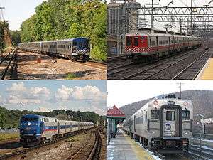 | |
|---|---|---|
| West of Hudson (operated by NJ Transit) | ||
| Non-revenue and Predecessor lines | ||
| Other | ||