Inwood–207th Street (IND Eighth Avenue Line)
Inwood–207 Street | |||||||
|---|---|---|---|---|---|---|---|
|
| |||||||
 | |||||||
| Station statistics | |||||||
| Address |
West 207th Street & Broadway New York, NY 10034 | ||||||
| Borough | Manhattan | ||||||
| Locale | Inwood | ||||||
| Coordinates | 40°52′04″N 73°55′16″W / 40.867672°N 73.921165°WCoordinates: 40°52′04″N 73°55′16″W / 40.867672°N 73.921165°W | ||||||
| Division | B (IND) | ||||||
| Line | IND Eighth Avenue Line | ||||||
| Services |
A | ||||||
| Transit connections |
| ||||||
| Structure | Underground | ||||||
| Platforms | 1 island platform | ||||||
| Tracks | 2 | ||||||
| Other information | |||||||
| Opened | September 10, 1932[1] | ||||||
| Station code | 143[2] | ||||||
| Accessible |
| ||||||
| Wireless service |
| ||||||
| Former/other names | Washington Heights–207th Street | ||||||
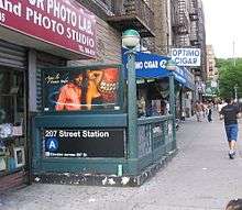
| Other entrances/ exits | Broadway and 207th Street, Broadway & 211th Street/Isham Street | ||||||
| Traffic | |||||||
| Passengers (2017) |
2,954,523[4] | ||||||
| Rank | 174 out of 425 | ||||||
| Station succession | |||||||
| Next north |
(Terminal): A | ||||||
| Next south |
Dyckman Street: A | ||||||
|
| |||||||
| Next |
none: A | ||||||
| Next |
175th Street: A | ||||||
| |||||||
| |||||||
| |||||||


Inwood–207th Street (formerly Washington Heights–207th Street) is the northern terminal station of the IND Eighth Avenue Line of the New York City Subway. Located at the intersection of 207th Street and Broadway in the Manhattan neighborhood of Inwood, near Inwood Hill Park, it is served by the A train at all times.
History
This underground station opened as Washington Heights–207th Street and was one of 28 stations opened on September 10, 1932. It served as the northern terminus of the Eighth Avenue Line south to Chambers Street/Hudson Terminal.[1][5][6]
Station layout
| G | Street level | Exit/entrance |
| M | Mezzanine | Fare control, station agent, MetroCard machines |
| P Platform level |
Track 4 | |
| Island platform, doors will open on the left or right | ||
| Track 3 | ||
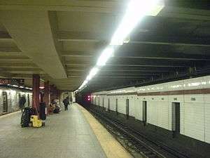
There is a single island platform between the two tracks, which are designated as Tracks A3 and A4, and end at bumper blocks just north of the platform at Chaining Station 1541+00. To the immediate south is an Interlocking Plant made up of a diamond crossover that allows trains to get to the correct track, and then proceed to share the right of way with the 207th Street Yard leads to Dyckman Street, which is the next station south.[6] This station terminal has been refurbished with two ADA-accessible elevators added. The mezzanine and street elevator shaft includes artwork titled At the Start...At Long Last by Sheila LaBrettville.[6] The terminal is operated by a Dispatcher's Office at the south end, while the Interlocking Plant is controlled by the CTC located in the 207th Street Yard.[6]
Exits
Nearby points of interest
References
- 1 2 New York Times, List of the 28 Stations on the New Eighth Ave Line, September 10, 1932, page 6
- ↑ "Station Developers' Information". Metropolitan Transportation Authority. Retrieved June 13, 2017.
- ↑ "NYC Subway Wireless – Active Stations". Transit Wireless Wifi. Retrieved May 18, 2016.
- ↑ "Facts and Figures: Annual Subway Ridership 2012–2017". Metropolitan Transportation Authority. July 12, 2018. Retrieved July 12, 2018.
- ↑ Crowell, Paul (September 10, 1932). "Gay Midnight Crowd Rides First Trains In The New Subway: Throngs at Station an Hour Before Time, Rush Turnstiles When Chains are Dropped" (PDF). New York Times. Retrieved November 8, 2015.
- 1 2 3 4 "Review of the A and C Lines" (PDF). Metropolitan Transportation Authority. December 11, 2015. Retrieved January 19, 2016.
- 1 2 3 4 "MTA Neighborhood Maps: Inwood" (PDF). Metropolitan Transportation Authority. 2015. Retrieved July 29, 2016.
External links
| Wikimedia Commons has media related to Inwood – 207th Street (IND Eighth Avenue Line). |
- nycsubway.org – IND 8th Avenue: 207th Street
- nycsubway.org – At the Start... At Long Last Artwork by Sheila Levrant de Bretteville (1999)
- Station Reporter – A Lefferts
- Station Reporter – A Rockaway
- MTA's Arts For Transit – Inwood–207th Street (IND Eighth Avenue Line)
- The Subway Nut — Inwood–207th Street Pictures
- 207th Street entrance from Google Maps Street View
- Isham Street/211th Street entrance from Google Maps Street View
- Platform from Google Maps Street View
| Eighth Avenue Line |
|
|---|---|
| |