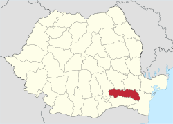
Ialomița County
| Ialomița County Județul Ialomița | ||
|---|---|---|
| County | ||
| ||
 | ||
| Coordinates: 44°38′N 27°18′E / 44.64°N 27.3°ECoordinates: 44°38′N 27°18′E / 44.64°N 27.3°E | ||
| Country | Romania | |
| Development region | Sud | |
| Historical region | Muntenia | |
| Capital | Slobozia | |
| Area | ||
| • Total | 4,453 km2 (1,719 sq mi) | |
| Area rank | 35th | |
| Population (2011) | ||
| • Total | 258,669[1] | |
| • Rank | 39th | |
| Telephone code | (+40) 243 or (+40) 343[2] | |
| ISO 3166 code | RO-IL | |
| Website |
County Council Prefecture | |

Ialomița County (Romanian pronunciation: [ˈjalomit͡sa] (![]()
Demographics
In 2011, it had a population of 258,669 and the population density was 58.08/km².
Romanians make up 95.6% of the population, the largest minority being the Romani people (4.1%).[3]
| Year | County population[4] |
|---|---|
| 1948 | 244,750 |
| 1956 | |
| 1966 | |
| 1977 | |
| 1992 | |
| 2002 | |
| 2011 |
Geography
This county has a total area of 4,453 km².
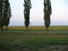
The county is situated in the Bărăgan Plain, all the area is flat crossed by small rivers with small but deep valleys.
Its east border is on Danube and the Ialomița River crosses the county from West to East about the middle. The Danube is split around the Ialomița Pond - the Old Danube branch and the Borcea branch.
Until 1940 (in the West part) and 1967 (in the East part) the county/plain was home of the great bustard (dropie in Romanian), with large populations of this bird. The birds disappeared because of the massive village buildout and hunting them for food.
Neighbours
- Constanța County in the East.
- Ilfov County in the West.
- Brăila County, Buzău County and Prahova County in the North.
- Călărași County in the South.
Economy
Agriculture is the main occupation in the county. Industry is almost entirely concentrated in the city of Slobozia.
The predominant industries in the county are:
- Food industry.
- Textile industry.
- Mechanical components industry.
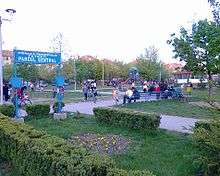
Tourism
The main tourist destinations are:
- The city of Slobozia.
Politics
The Ialomița County Council, elected at the 2016 local government elections, is made up of 31 counselors, with the following party composition:[5]
| Party | Seats | Current County Council | ||||||||||||||||||
|---|---|---|---|---|---|---|---|---|---|---|---|---|---|---|---|---|---|---|---|---|
| Social Democratic Party | 18 | |||||||||||||||||||
| National Liberal Party | 10 | |||||||||||||||||||
| Alliance of Liberals and Democrats | 3 | |||||||||||||||||||
Administrative divisions
Ialomița County has 3 municipalities, 4 towns and 59 communes.
- Municipalities
- Towns
- Communes
- Adâncata
- Albești
- Alexeni
- Andrășești
- Armășești
- Axintele
- Balaciu
- Bărcănești
- Bărbulești
- Borănești
- Bordușani
- Bucu
- Buești
- Ciocârlia
- Ciochina
- Ciulnița
- Cocora
- Colelia
- Cosâmbești
- Coșereni
- Drăgoești
- Dridu
- Făcăeni
- Gârbovi
- Gheorghe Doja
- Gheorghe Lazăr
- Giurgeni
- Grindu
- Grivița
- Gura Ialomiței
- Ion Roată
- Jilavele
- Maia
- Manasia
- Mărculești
- Mihail Kogălniceanu
- Miloșești
- Moldoveni
- Movila
- Movilița
- Munteni-Buzău
- Ograda
- Perieți
- Platonești
- Rădulești
- Reviga
- Roșiori
- Sălcioara
- Sărățeni
- Săveni
- Scânteia
- Sfântu Gheorghe
- Sinești
- Stelnica
- Sudiți
- Traian
- Valea Ciorii
- Valea Măcrișului
- Vlădeni
Historical county
| Județul Ialomița | ||
|---|---|---|
| County (Județ) | ||
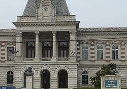 The Ialomița County prefecture building from the interwar period, now the prefecture building of Călărași County. | ||
| ||
 | ||
| Country |
| |
| Historic region | Muntenia | |
| Capital city (Reședință de județ) | Călărași | |
| Area | ||
| • Total | 7,095 km2 (2,739 sq mi) | |
| Population (1930) | ||
| • Total | 293,352 | |
| • Density | 41/km2 (110/sq mi) | |
| Time zone | UTC+2 (EET) | |
| • Summer (DST) | UTC+3 (EEST) | |
Historically, the county was located in the southeastern part of the Greater Romania, in the southeastern part of the historical region of Muntenia. The county comprised a large part of the current Ialomița County and of today's Călărași County. It was bordered on the west by Ilfov, to the north by the counties of Prahova, Buzău and Brăila, to the east by the county Constanța County, and in the south by Durostor County.
With an area of 7,095 square kilometres (2,739 sq mi), Ialomiţa County was one of the largest counties of Greater Romania.
Administration

The county was originally divided administratively into five districts (plăṣi):[6]
- Plasa Călărași, headquartered at Călărași
- Plasa Lehliu, headquartered at Lehliu
- Plasa Slobozia, headquartered at Slobozia
- Plasa Țăndărei, headquartered at Țăndărei
- Plasa Urziceni, headquartered at Urziceni
Subsequently, three new districts were added:
- Plasa Căzănești, headquartered at Căzănești
- Plasa Dragoș Vodă, headquartered at Dragoș Vodă
- Plasa Fetești, headquartered at Fetești
Population
According to the 1930 census data, the county population was 293,352 inhabitants, ethnically divided as follows: 96.6% Romanians, 2.5% Romanies, 0.2% Jews, as well as other minorities. From the religious point of view, the population was 99.3% Eastern Orthodox, 0.2% Jewish, 0.1% Roman Catholic, as well as other minorities.
Urban population
In 1930, the county's urban population was 34,260 inhabitants, comprising 90.2% Romanians, 6.0% Romnanies, 1.3% Jews, as well as other minorities. From the religious point of view, the urban population was composed of 97.4% Eastern Orthodox, 1.4% Jewish, 0.5% Roman Catholic, as well as other minorities.
References
| Wikimedia Commons has media related to Ialomița County. |
- ↑ "COMUNICAT DE PRESĂ : 2 februarie 2012 privind rezultatele provizorii ale Recensământului Populaţiei şi Locuinţelor – 2011" (PDF). Ialomita.insse.ro. Retrieved 11 April 2018.
- ↑ The number used depends on the numbering system employed by the phone companies on the market.
- ↑ National Institute of Statistics, "Populația după etnie" Archived 2009-08-16 at the Wayback Machine.
- ↑ National Institute of Statistics, "Populația la recensămintele din anii 1948, 1956, 1966, 1977, 1992 și 2002" Archived 2006-09-22 at the Wayback Machine.
- ↑ "Mandate de CJ pe judete si competitori" (in Romanian). Biroul Electoral Central. 10 June 2016. Retrieved 16 June 2016.
- ↑ Portretul României Interbelice - Județul Ialomița