Herøy, Nordland
| Herøy kommune | |||
|---|---|---|---|
| Municipality | |||
.jpg) De syv søstre mountains seen from Herøy | |||
| |||
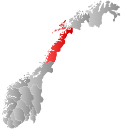
 Herøy within Nordland | |||
| Coordinates: 65°59′55″N 12°13′02″E / 65.99861°N 12.21722°ECoordinates: 65°59′55″N 12°13′02″E / 65.99861°N 12.21722°E | |||
| Country | Norway | ||
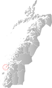
| County | Nordland | ||
| District | Helgeland | ||
| Established | 1864 | ||
| Administrative centre | Herøy | ||
| Government | |||
| • Mayor (2003) | Arnt Frode Jensen (Ap) | ||
| Area | |||
| • Total | 64.40 km2 (24.86 sq mi) | ||
| • Land | 63.81 km2 (24.64 sq mi) | ||
| • Water | 0.59 km2 (0.23 sq mi) | ||
| Area rank | #405 in Norway | ||
| Population (2017) | |||
| • Total | 1,788 | ||
| • Rank | #339 in Norway | ||
| • Density | 28/km2 (70/sq mi) | ||
| • Change (10 years) | 6.3% | ||
| Demonym(s) | Herøfjerding[1] | ||
| Time zone | UTC+01:00 (CET) | ||
| • Summer (DST) | UTC+02:00 (CEST) | ||
| ISO 3166 code | NO-1818 | ||
| Official language form | Bokmål | ||
| Website |
heroy-no | ||
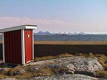
Herøy is a municipality in Nordland county, Norway. It is part of the Helgeland traditional region. The administrative centre of the municipality is the village of Silvalen. The municipality is located about 15 kilometres (9.3 mi) west of the town of Sandnessjøen.
The 64-square-kilometre (25 sq mi) municipality is the 405th largest by area out of the 422 municipalities in Norway. Herøy is the 339th most populous municipality in Norway with a population of 1,788. The municipality's population density is 28 inhabitants per square kilometre (73/sq mi) and its population has increased by 6.3% over the last decade.[2]
General information
The municipality of Herøy was established in 1864 when it was separated from Alstahaug. Initially the population of Herøy was 2,438. On 1 July 1917, the northern district of Herøy (population: 1,530) was separated from Herøy to become the new municipality of Nordvik. This left Herøy with 2,555 residents.
On 1 January 1962 the part of Herøy on the island of Dønna (population: 19) was transferred to the new municipality of Dønna. On 1 January 1965 the Husvær/Sandværet island groups (population: 461) were transferred from Alstahaug to Herøy.[3]
Name
The municipality is named after the islands of Søndre Herøya and Nordre Herøya (Old Norse: Herøyjar). The first element is herr which means "army" (here in the sense of skipaherr which means "military fleet") and the last element is the definite form of øy which means "island". The sound between the islands was probably a meeting place for the Leidang fleet of the district. Historically, the name was spelled Herø.[4][5]
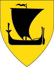
Coat-of-arms
The coat of arms is from modern times; it was granted on 3 July 1987. The arms show three gold-colored oars on a blue background. They symbolize the history of boating in the island municipality, and it also a canting of the name of the municipality which means a place where a fleet gathers.[4]
Churches
The Church of Norway has one parish (sokn) within the municipality of Herøy. It is part of the Nord-Helgeland prosti (deanery) in the Diocese of Sør-Hålogaland.
| Parish (Sokn) | Church Name | Location of the Church | Year Built |
|---|---|---|---|
| Herøy | Herøy Church | Silvalen | 12th century |
| Gåsvær Chapel | Gåsvær | 1951 | |
| Husvær Chapel | Husvær | 1936 | |
| Sandvær Chapel | Sandværet | 1947 |
Geography
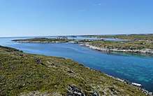
The municipality of Herøy consists of about 1700 little islands and islets. The main islands are Nord-Herøy, Sør-Herøy, Tenna, Ytre Øksningan, Indre Øksningan, Seløya, and Staulen— all of which are connected by bridges including Åkviksundet Bridge, Hoholmen Bridge, Kalvøyrevet Bridge. Most islands are low and close to the sea surface.[6]
There are also several smaller outlying island groups such as Gåsvær, Husvær, and Sandværet. Ytterholmen Lighthouse is located in the far western part of the municipality.
Government
All municipalities in Norway, including Herøy, are responsible for primary education (through 10th grade), outpatient health services, senior citizen services, unemployment and other social services, zoning, economic development, and municipal roads. The municipality is governed by a municipal council of elected representatives, which in turn elect a mayor.
Municipal council
The municipal council (Kommunestyre) of Herøy is made up of 19 representatives that are elected to four year terms. Currently, the party breakdown is as follows:[7]
| Party Name | Name in Norwegian | Number of representatives | |
|---|---|---|---|
| Labour Party | Arbeiderpartiet | 12 | |
| Progress Party | Fremskrittspartiet | 2 | |
| Centre Party | Senterpartiet | 2 | |
| Socialist Left Party | Sosialistisk Venstreparti | 1 | |
| Local Lists | Lokale lister | 2 | |
| Total number of members: | 19 | ||
Economy
The main industries in the municipality is fishing, fish farming and processing activities associated with this. Other important industries are agriculture, transportation, service industries, and tourism.
References
- ↑ "Navn på steder og personer: Innbyggjarnamn" (in Norwegian). Språkrådet. Retrieved 2015-12-01.
- ↑ Statistisk sentralbyrå (2017). "Table: 06913: Population 1 January and population changes during the calendar year (M)" (in Norwegian). Retrieved 2017-09-16.
- ↑ Jukvam, Dag (1999). "Historisk oversikt over endringer i kommune- og fylkesinndelingen" (PDF) (in Norwegian). Statistisk sentralbyrå.
- 1 2 "Herøys kommunevåpen" (in Norwegian). Archived from the original on 2011-07-19. Retrieved 2008-11-23.
- ↑ Rygh, Oluf (1905). Norske gaardnavne: Nordlands amt (in Norwegian) (16 ed.). Kristiania, Norge: W. C. Fabritius & sønners bogtrikkeri. p. 100.
- ↑ Store norske leksikon. "Herøy – kommune i Nordland" (in Norwegian). Retrieved 2011-12-30.
- ↑ "Table: 04813: Members of the local councils, by party/electoral list at the Municipal Council election (M)" (in Norwegian). Statistics Norway. 2015.
External links
- Municipal fact sheet from Statistics Norway (in Norwegian)
| Wikimedia Commons has media related to Herøy, Nordland. |

| |||||||||||||||||
| |||||||||||||||||