Fedje
| Fedje kommune | |||
|---|---|---|---|
| Municipality | |||
 View of the Hellisøy lighthouse | |||
| |||
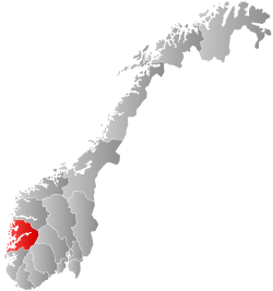
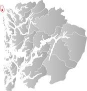 Fedje within Hordaland | |||
| Coordinates: 60°46′08″N 04°43′50″E / 60.76889°N 4.73056°ECoordinates: 60°46′08″N 04°43′50″E / 60.76889°N 4.73056°E | |||
| Country | Norway | ||
| County | Hordaland | ||
| District | Nordhordland | ||
| Administrative centre | Fedje | ||
| Government | |||
| • Mayor (2015) | Stian Herøy (H) | ||
| Area | |||
| • Total | 9.28 km2 (3.58 sq mi) | ||
| • Land | 8.95 km2 (3.46 sq mi) | ||
| • Water | 0.33 km2 (0.13 sq mi) | ||
| Area rank | #420 in Norway | ||
| Population (2017) | |||
| • Total | 587 | ||
| • Rank | #414 in Norway | ||
| • Density | 65.6/km2 (170/sq mi) | ||
| • Change (10 years) | -5.3% | ||
| Demonym(s) | Fedjing[1] | ||
| Time zone | UTC+01:00 (CET) | ||
| • Summer (DST) | UTC+02:00 (CEST) | ||
| ISO 3166 code | NO-1265 | ||
| Official language form | Nynorsk | ||
| Website |
www | ||

Fedje is an island municipality in the Nordhordland region of Hordaland county, Norway. The administrative centre of the municipality is the village of Fedje. The other main population centre is the village of Fedje. The traditional economic activity of the inhabitants is fishing.
The 9-square-kilometre (3.5 sq mi) municipality is the 420th largest by area out of the 422 municipalities in Norway. Fedje is the 414th most populous municipality in Norway with a population of 587. The municipality's population density is 65.6 inhabitants per square kilometre (170/sq mi) and its population has decreased by 5.3% over the last decade.[2] The municipality consists of the main island of Fedje which is also surrounded by about 125 smaller islands and rocks mostly north of the main island. The name Fedje applies both to the main island, the main village, and to all the islands and rocks as a whole municipality.
In 2016 the chief of police formally suggested that the police station in Austrheim og Fedje, be closed down.[3]
General information


Historically, the islands of Fedje belonged to the prestegjeld of Lindås. In 1910, the northwestern part of Lindås was separated to become the new municipality of Austrheim (which included Fedje). On 1 January 1947, all of Austrheim located west of the Fedjefjorden (population: 920) was separated to become the new municipality of Fedje.[4]
Name
The Old Norse form of the name was Feðjar, closely related to Gothic word "faþa" which means "fence" or "wall". The meaning here refers to a row of islands or archipelago, separating the inshore waters (now called the Fedjefjorden) from the ocean.[5]
Coat-of-arms
The coat-of-arms is from modern times; they were granted on 13 July 1990. The arms show two silver oars on a blue background. This symbolizes the rich boating history of this island municipality.[6]
Churches
The Church of Norway has one parish (sokn) within the municipality of Fedje. It is part of the Nordhordland deanery in the Diocese of Bjørgvin.
| Parish (Sokn) | Church Name | Location of the Church | Year Built |
|---|---|---|---|
| Fedje | Fedje Church | Fedje | 1941 |
Education
Fedje has an elementary school, and a junior high school, both of which are situated in the center of the island, and in the same building. The school is also used as a movie theater twice a week.
History
| Historical population | ||
|---|---|---|
| Year | Pop. | ±% |
| 1951 | 940 | — |
| 1960 | 932 | −0.9% |
| 1970 | 873 | −6.3% |
| 1980 | 849 | −2.7% |
| 1990 | 730 | −14.0% |
| 2000 | 682 | −6.6% |
| 2010 | 594 | −12.9% |
| 2017 | 587 | −1.2% |
| Source: Statistics Norway. | ||
There are traces of human activity on Fedje from as long as 4,000 years ago. In the 18th century, Fedje was an important trading place, with the small island of Kræmmerholmen being the location where the trading took place. Kræmmerholmen was reopened in 1991, and was a restaurant/hotel/museum area, but closed in September 2008. Fedje was previously a substantial producer of peat. The peat led to the construction of a railway. The railway was given up together with the peat industry in 1920.
During the Second World War Fedje was occupied by over 300 German soldiers. There are still remains of the German cannons and bunkers all over the island, especially in the western part close to the traffic station, which is actually built on the remains of a German radar station.
In February 1945, the German submarine U-864 was sunk by the British submarine HMS Venturer outside western Fedj, the only instance in history of a submarine being sunk by another submarine while both were submerged. The wreck of the U-boat was discovered in 2003 lying in 150 metres (490 ft) of water, 2 nmi (3.7 km; 2.3 mi) west of Fedje.[7] Its cargo included 67 short tons (61 t) of mercury which was being shipped to Japan. Contained in 1,857 rusting steel bottles in the vessel's keel, the mercury was discovered to be leaking out and currently poses a severe environmental threat. The rusting mercury bottles, the delicate condition of the wreck, and the presence of live torpedoes aboard it make the raising or salvage of U-864 extremely hazardous, and it has instead been proposed that the wreck be entombed.[8]
On 12 January 2007, M/V Server sunk outside Fedje. The ship leaked oil and caused major environmental damage. But due to intensive efforts to clean the coves and beaches, very few traces can be found today.
Government
All municipalities in Norway, including Fedje, are responsible for primary education (through 10th grade), outpatient health services, senior citizen services, unemployment and other social services, zoning, economic development, and municipal roads. The municipality is governed by a municipal council of elected representatives, which in turn elect a mayor.
Municipal council
The municipal council (Kommunestyre) of Fedje is made up of 15 representatives that are elected to four year terms. Currently, the party breakdown is as follows:[9]
| Party Name | Name in Norwegian | Number of representatives | |
|---|---|---|---|
| Labour Party | Arbeiderpartiet | 3 | |
| Progress Party | Framstegspartiet | 2 | |
| Conservative Party | Høgre | 5 | |
| Christian Democratic Party | Kristelig Folkeparti | 4 | |
| Local Lists | Lokale lister | 1 | |
| Total number of members: | 15 | ||
Geography

The highest point on Fedje is the 42-metre (138 ft) high hill called Fedjebjørnen. The largest lake is Storevatnet.
Islands
Other than the main island of Fedje, the best known smaller island is called Holmengrå. Holmengrå is the site of the 35-metre (115 ft) tall Holmengrå Lighthouse. In the southern part of Fedje which is called Stormark, there is a lighthouse called Hellisøy Lighthouse, maybe the most famous feature of Fedje. Hellisøy Lighthouse was built in 1855. The 32.3-metre (106 ft) tall tower is painted red and white. The islands of Fedje are all located on the western side of the Fedjefjorden.
People
The population of the island community is decreasing due to the high percentage of people over 60 years (25% as of 1 January 2003), and because many people decide to move from the island, many because of the lack of work.
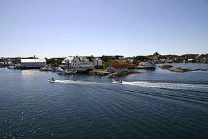
Most of the people live on the lagoon-like northern part of the island in the village of Fedje where there is a grocery store, Fedje Church, and the ferry quay. Fedje used to be inhabited by fishermen and whalers. These days many are working on commercial ships or in the oil industry. By doing so they can still live on the island without having to work there.
Sports
The main sporting activity on Fedje is football, which can be played on the football grounds in the eastern part of the island. The football ground is also the home ground of the local football team called Fedje A-lag. The club is currently playing in the Norwegian 6th division. Swimming is also popular, as there is a beautiful beach located on Fedje, which is to be found in the centre of the island on the shoreline of Lake Husavatnet. The water is clean and brackish, as it have a small opening to the sea which makes the tide flush it with sea water from time to time.
Infrastructure
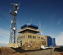
Fedje Vessel Traffic Service Centre has been operating since 1 September 1992. It surveys the coast to allow safe passage to Mongstad and Sture. It also serves as a pilot station.[10] Next to the station is Fedje Heliport, Høgden.
The island is supplied with power, telephone, and internet cables from an underwater cordless router to the mainland. A ferry, crossing 20 times a day, connects Fedje to the mainland. The voyage lasts for about 30 minutes. Fedje is about a 1-hour 40 minute drive (including a 30-minute ferry voyage) from the city of Bergen.
References
- ↑ "Navn på steder og personer: Innbyggjarnamn" (in Norwegian). Språkrådet. Retrieved 2015-12-01.
- ↑ Statistisk sentralbyrå (2017). "Table: 06913: Population 1 January and population changes during the calendar year (M)" (in Norwegian). Retrieved 2017-10-28.
- ↑ https://www.nrk.no/hordaland/slik-vil-songstad-ha-vest-politidistrikt-1.13284803
- ↑ Jukvam, Dag (1999). "Historisk oversikt over endringer i kommune- og fylkesinndelingen" (PDF) (in Norwegian). Statistisk sentralbyrå.
- ↑ Rygh, Oluf (1919). Norske gaardnavne: Nordre Bergenhus amt (in Norwegian) (12 ed.). Kristiania, Norge: W. C. Fabritius & sønners bogtrikkeri. p. 426.
- ↑ "Civic heraldry of Norway - Norske Kommunevåpen". Heraldry of the World. Retrieved 2014-04-07.
- ↑ "U-864: Extended investigations 2006". Norwegian Coastal Administration. 2006. Archived from the original on 18 August 2006. Retrieved 23 November 2011.
- ↑ "The Norwegian Coastal Administration recommends encasing and covering the wreck of the submarine U-864" (PDF). Norwegian Coastal Administration press release. 19 December 2006. Archived from the original (PDF) on 2 July 2007. Retrieved 14 January 2007.
- ↑ "Table: 04813: Members of the local councils, by party/electoral list at the Municipal Council election (M)" (in Norwegian). Statistics Norway. 2015.
- ↑ Røyrane, Anne (2 September 1992). "Fedje-sentralen skal gjøre kysten tryggare". Bergens Tidende (in Norwegian). p. 6.
External links
| Wikimedia Commons has media related to Fedje. |
| Look up Fedje in Wiktionary, the free dictionary. |

- Municipal fact sheet from Statistics Norway (in Norwegian)