Heathcote Valley
| Heathcote Valley | |
|---|---|
| Suburb | |
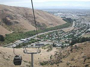 View from gondola into Heathcote Valley | |
| Area | |
| • Total | 7.3746 km2 (2.8473 sq mi) |
| Elevation | 100 m (300 ft) |
| Population (2006) | |
| • Total | 1,983 |
| • Density | 270/km2 (700/sq mi) |
Heathcote Valley is a suburb of Christchurch, New Zealand. It is named after Sir William Heathcote, who was secretary of the Canterbury Association.[1]
Location
The suburb is dominated by the approaches to the Lyttelton road tunnel, a major arterial that passes through the Port Hills. The road is part of the State Highway 74 network. The Main South Railway line passes through the suburb, before entering the Lyttelton rail tunnel that connects with the port of Lyttelton.
The suburb is nestled at the foot of the steep volcanic crags that form the northern edge of the hills, some 8 kilometres (5 mi) southeast of the city centre. Heathcote Valley is also the starting point of the Christchurch Gondola, which goes up to Mount Cavendish on the Port Hills. The Gondola officially opened on 24 November 1992.[2]
History

Heathcote Valley has a long history of malting, the latest being the Canterbury Malting Company. The disused Maltworks, which closed in 1999, dominated the skyline.[3] The distinctive Maltworks tower along with the rest of the remaining buildings were demolished in February 2012 to make way for residential developments.
Relation to Heathcote River
Despite its name, Heathcote Valley is situated some two kilometres south of the Heathcote River, which does not flow through the suburb but rather flows east across a wide plain.
Notable residents
- Walter Argus NZ rugby international who bought a market garden in Heathcote Valley in 1949
References
- ↑ "Heathcote". NZ History. New Zealand Ministry for Culture and Heritage. Retrieved 29 August 2018.
- ↑ "THE CHRISTCHURCH GONDOLA OPENED – 24TH OCTOBER 1992". PEELING BACK HISTORY. Retrieved 29 August 2018.
- ↑ http://canterbury.cyberplace.co.nz/community/CAFCA/cafca00/Jul00.html Background reading on the company closure