St Albans, New Zealand
| St Albans | |
|---|---|
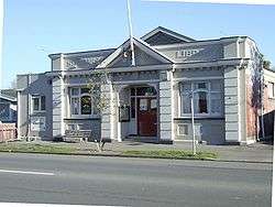 The old St Albans library, since demolished following earthquake damage | |
| Area | |
| • Total | 1.991 km2 (0.769 sq mi) |
| Population (2017) | |
| • Total | 7,810 |
| • Density | 3,900/km2 (10,000/sq mi) |
St Albans is one of the largest suburbs of Christchurch, New Zealand. It lies some two kilometres north of the Christchurch Central Business District. To the east of St Albans is Shirley and to the west is Merivale. The suburb falls within the Christchurch Central electorate and is represented by Duncan Webb, who has been the MP since the general election of 2017.
History
Originally a working-class settlement, St Albans was a separate borough from 1881 until 1903 when it became part of Christchurch City. St Albans was named after George Dickinson’s farm, which lay to the south of the St Albans Creek. He had called his farm St Albans in memory of his cousin Harriet Mellon, an actress, who had become the Duchess of St Albans.[1]
Boundaries
The St Albans borough boundaries are: Mays Road in the north, Hills Road in the east, Bealey Avenue to the south, and Rossall Street to the west.
Community facilities
The hub of St Albans is Edgeware Village on Edgeware Road which contains a small number of well-supported shops. The suburb contains four schools, St Albans Primary School,[2] St Albans Catholic School,[3], Mairehau Primary School, and St Francis of Assisi. The three main parks in the suburb are St Albans Park,[4] Abberley Park, and Malvern Park.[5] Sports facilities include Canterbury United Football Club's stadium, English Park, and Rugby Park, the home of the Crusaders professional rugby union team.
St Albans Neighbourhood News
St Albans is known for its sense of cohesiveness and community spirit. This has manifested itself in the local monthly paper, the St Albans Neighbourhood News,[6] which was first published by a group of local residents in 1993 and is still going to this day. Distributed to 5,000 homes and businesses, the paper has recently been expanded to fill 16 pages. Over the years it has been central in numerous community-related issues including local planning, Packe Street Park, the Edgeware Road Tragedy, and the closure of Edgeware swimming pool (to which it was editorially opposed). After the community regained control of the site, it was announced that the pool would be rebuilt with a generous donation from a local resident.[7]
Earthquake damage
The suburb escaped severe damage in the 2010 Canterbury earthquake. Many chimneys came down but only a few complete houses were affected. In the 22 February 2011 earthquake, however, the suburb was hit hard. Many houses, supermarkets, and shops were significantly damaged with a lot ending up totally demolished. In July 2011, the demolition of the former library, which houses the community centre, was ordered by the Canterbury Earthquake Recovery Authority.[8] By 2014 the extent of the damage to drainage systems and lowered ground levels had become apparent, with the regular flooding of a series of streets known as the Flockton Basin. [9]
Notable residents
- Hugh Acland (1874–1956), prominent surgeon and later owner of Chippenham[10]
- John Evans Brown (1827–1895), first MP for St Albans, after whom Browns Rd is named, and resident at Chippenham[11]
- Wizard of New Zealand (born 1932), lived in the suburb until his Cranford Street home was destroyed by fire in September 2003
References
- ↑ St Albans, from Swamp to Suburbs, An Informal History. New Zealand federation of University Women Canterbury Branch. 1989. pp. 13–14. ISBN 0-473-00693-6.
- ↑ "St Albans School | Welcome to our website". Stalbans.school.nz. 2013-07-04. Retrieved 2014-02-16.
- ↑ "St Albans Catholic School (Christchurch) .::. Welcome". Stalbanscatholic.school.nz. Retrieved 2014-02-16.
- ↑ "A to Z of Christchurch Parks - St Albans Park". .ccc.govt.nz. Retrieved 2014-02-16.
- ↑ "A to Z of Christchurch Parks - Malvern Park". .ccc.govt.nz. Retrieved 2014-02-16.
- ↑
- ↑ Conway, Glenn (26 March 2010). "Edgeware community wins pool fight". The Press. Retrieved 13 November 2011.
- ↑ "Deconstruction of damaged Council-owned community facility". Christchurch City Council. Retrieved 23 July 2011.
- ↑ Cairns, Lois (6 March 2014). "Flockton flood protection two years away". The Press. Retrieved 1 December 2015.
- ↑ Maling, Peter B. "Acland, Hugh Thomas Dyke". Dictionary of New Zealand Biography. Ministry for Culture and Heritage. Retrieved 7 January 2012.
- ↑ "Chippenham Lodge". Register of Historic Places. Heritage New Zealand. Retrieved 16 February 2014.