Rapaki
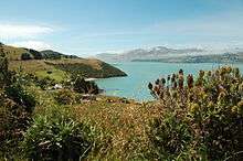
View of Lyttelton Harbour and Rapaki
Rapaki is a small settlement within the Whakaraupo (Lyttelton, New Zealand) Harbour basin.[1]
Rapaki is one of four Banks Peninsula rūnanga, or communities based around marae (tribal meeting grounds).[2] The Rapaki Marae, also known as Te Wheke Marae, is a meeting ground of Ngāi Tahu and its Te Hapū o Ngāti Wheke branch.[3] It includes Wheke wharenui (meeting ground).[4]
Rapaki is overlooked by the peak Te Poho o Tamatea. According to one legend, the Ngāi Tahu chief Te Rakiwhakaputa named the place by laying his waist mat (Rapaki) down to claim it.[5] The full name of Rapaki is Te Rapaki o Te Rakiwhakaputa, meaning the waist mat of Te Rakiwhakaputa.[6]
References
| Wikimedia Commons has media related to Rapaki. |
- ↑ Te Ara Encyclopedia of New Zealand
- ↑ Ngāi Tahu Rapaki description
- ↑ "Te Kāhui Māngai directory". tkm.govt.nz. Te Puni Kōkiri.
- ↑ "Māori Maps". maorimaps.com. Te Potiki National Trust.
- ↑ Ngai Tahu Rapaki description
- ↑ Rapaki marae introduction
Coordinates: 43°36′14″S 172°40′46″E / 43.6040°S 172.6795°E
This article is issued from
Wikipedia.
The text is licensed under Creative Commons - Attribution - Sharealike.
Additional terms may apply for the media files.