Cashmere, New Zealand
| Cashmere | |
|---|---|
 Cashmere | |
| Coordinates: 43°34′22″S 172°37′52″E / 43.572751°S 172.631100°ECoordinates: 43°34′22″S 172°37′52″E / 43.572751°S 172.631100°E | |
| Area | |
| • Total | 15.3003 km2 (5.9075 sq mi) |
| Population (2006) | |
| • Total | 6,876 |
| • Density | 450/km2 (1,200/sq mi) |
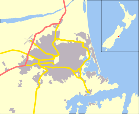
The suburb of Cashmere rises above the southern end of the city of Christchurch in New Zealand’s South Island.
Geography
Cashmere is situated on the north side of the Port Hills, immediately above the southern terminus of Christchurch’s main street, Colombo Street. Five kilometres south of the city centre, a commanding view of the city can be had from Victoria Park, at the upper end of the suburb. Above Victoria Park is Sugarloaf, a 496 m peak, which is the location of the 119 m transmission tower for local radio and TV stations.
History
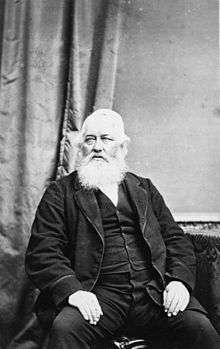
Cashmere takes its name from Sir John Cracroft Wilson's farm, which originally occupied the present suburb. Wilson was born in India and named his farm after Kashmir (Cashmere is an early British spelling of Kashmir).[1] In 1979, the house Wilson built for his Indian workers became a function centre known as "The Old Stone House". The building has been significantly damaged and restored twice, following a fire in 1971 and earthquakes in 2010 and 2011.[2]
Cashmere has a reputation as one of the country's more well-to-do and refined suburbs, and the 2006 census revealed there was generally a higher income concentration in the suburb.
Buildings and infrastructure
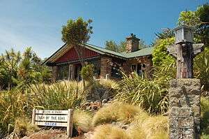
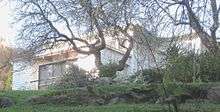
Two of Harry Ell's rest houses, the Sign of the Takahe and the Sign of the Kiwi, are located in Cashmere. Both are Category I heritage buildings.[3][4] Dame Ngaio Marsh's former house in Valley Road is a museum run in her memory. It is registered by Heritage New Zealand as a Category I heritage item.[5]
Schools include Cashmere Primary, Thorrington Primary and Cashmere High School. Princess Margaret Hospital, built in 1959, was once thought to become the main hospital of Christchurch, but it was too far from the central city.[6]
The Cashmere Club is home to many local sports groups including rugby, soccer, bowls, badminton, darts, squash and small bore rifle shooting. The Canterbury Ring Laser facility is located in the Cracroft Caverns, an underground bunker complex built during World War II. Christchurch Adventure Park is a mountain bike park that opened in December 2016.[7]
Notable residents
- Ruth Dyson (born 1957), politician
- Norman Hardie (born 1924), mountaineer[8]
- Ngaio Marsh (1895–1982), world-renowned crime writer who lived in 37 Valley Road from 1907 until her death[9]
- John Cracroft Wilson (1808–1881), Member of Parliament
- Ursula Bethell (1874–1945), poet
References
- ↑ Kristiansen, Tessa. "Wilson, John Cracroft - Biography". Dictionary of New Zealand Biography. Ministry for Culture and Heritage. Retrieved 10 July 2011.
- ↑ Cracroft Community Centre Inc. "History". The Old Stone House. Retrieved 27 July 2018.
- ↑ "Sign of the Takahe". Register of Historic Places. Heritage New Zealand. Retrieved 10 July 2011.
- ↑ "Sign of the Kiwi". Register of Historic Places. Heritage New Zealand. Retrieved 10 July 2011.
- ↑ "Ngaio Marsh House". Register of Historic Places. Heritage New Zealand. Retrieved 10 July 2011.
- ↑ "Cashmere (later Princess Margaret) Hospital, shown under construction". Christchurch City Libraries. Retrieved 6 June 2011.
- ↑ Redmond, Adele (17 December 2016). "Christchurch Adventure Park opens to Stoke Pass holders on Saturday". The Press. Retrieved 17 December 2016.
- ↑ "Man of the mountains". The Press. 29 November 2008. Retrieved 27 August 2016.
- ↑ Stafford, Jane. "Marsh, Edith Ngaio 1895 - 1982". Dictionary of New Zealand Biography. Ministry for Culture and Heritage. Retrieved 10 July 2011.