Genouillac, Charente
| Genouillac | |
|---|---|
| Commune | |
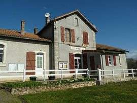 Town hall | |
 Genouillac Location within Nouvelle-Aquitaine region  Genouillac | |
| Coordinates: 45°51′13″N 0°34′19″E / 45.8536°N 0.5719°ECoordinates: 45°51′13″N 0°34′19″E / 45.8536°N 0.5719°E | |
| Country | France |
| Region | Nouvelle-Aquitaine |
| Department | Charente |
| Arrondissement | Confolens |
| Canton | Charente-Bonnieure |
| Intercommunality | Haute-Charente |
| Government | |
| • Mayor (2008–2014) | Jacques Marsac |
| Area1 | 14.59 km2 (5.63 sq mi) |
| Population (2008)2 | 588 |
| • Density | 40/km2 (100/sq mi) |
| Time zone | UTC+1 (CET) |
| • Summer (DST) | UTC+2 (CEST) |
| INSEE/Postal code | 16149 /16270 |
| Elevation |
154–267 m (505–876 ft) (avg. 227 m or 745 ft) |
|
1 French Land Register data, which excludes lakes, ponds, glaciers > 1 km2 (0.386 sq mi or 247 acres) and river estuaries. 2 Population without double counting: residents of multiple communes (e.g., students and military personnel) only counted once. | |
Genouillac is a commune in the Charente department in southwestern France.
Population
| Historical population | ||
|---|---|---|
| Year | Pop. | ±% |
| 1793 | 869 | — |
| 1800 | 750 | −13.7% |
| 1806 | 818 | +9.1% |
| 1821 | 911 | +11.4% |
| 1831 | 850 | −6.7% |
| 1841 | 908 | +6.8% |
| 1846 | 900 | −0.9% |
| 1851 | 910 | +1.1% |
| 1856 | 881 | −3.2% |
| 1861 | 834 | −5.3% |
| 1866 | 787 | −5.6% |
| 1872 | 757 | −3.8% |
| 1876 | 813 | +7.4% |
| 1881 | 827 | +1.7% |
| 1886 | 971 | +17.4% |
| 1891 | 865 | −10.9% |
| 1896 | 886 | +2.4% |
| 1901 | 876 | −1.1% |
| 1906 | 957 | +9.2% |
| 1911 | 1,016 | +6.2% |
| 1921 | 899 | −11.5% |
| 1926 | 975 | +8.5% |
| 1931 | 952 | −2.4% |
| 1936 | 943 | −0.9% |
| 1946 | 788 | −16.4% |
| 1954 | 843 | +7.0% |
| 1962 | 914 | +8.4% |
| 1968 | 900 | −1.5% |
| 1975 | 863 | −4.1% |
| 1982 | 715 | −17.1% |
| 1990 | 574 | −19.7% |
| 1999 | 575 | +0.2% |
| 2008 | 588 | +2.3% |
See also
References
| Wikimedia Commons has media related to Genouillac (Charente). |
This article is issued from
Wikipedia.
The text is licensed under Creative Commons - Attribution - Sharealike.
Additional terms may apply for the media files.