Gourville
| Gourville | |
|---|---|
| Commune | |
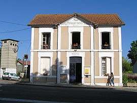 Town hall | |
 Gourville Location within Nouvelle-Aquitaine region  Gourville | |
| Coordinates: 45°49′51″N 0°00′50″W / 45.8308°N 0.0139°WCoordinates: 45°49′51″N 0°00′50″W / 45.8308°N 0.0139°W | |
| Country | France |
| Region | Nouvelle-Aquitaine |
| Department | Charente |
| Arrondissement | Cognac |
| Canton | Val de Nouère |
| Intercommunality | Rouillacais |
| Government | |
| • Mayor (2008–2014) | Marie-France Basset |
| Area1 | 12.92 km2 (4.99 sq mi) |
| Population (2008)2 | 653 |
| • Density | 51/km2 (130/sq mi) |
| Time zone | UTC+1 (CET) |
| • Summer (DST) | UTC+2 (CEST) |
| INSEE/Postal code | 16156 /16170 |
| Elevation |
55–155 m (180–509 ft) (avg. 124 m or 407 ft) |
|
1 French Land Register data, which excludes lakes, ponds, glaciers > 1 km2 (0.386 sq mi or 247 acres) and river estuaries. 2 Population without double counting: residents of multiple communes (e.g., students and military personnel) only counted once. | |
Gourville is a commune in the Charente department in southwestern France.
Population
| Historical population | ||
|---|---|---|
| Year | Pop. | ±% |
| 1793 | 1,115 | — |
| 1800 | 1,184 | +6.2% |
| 1806 | 1,119 | −5.5% |
| 1821 | 1,158 | +3.5% |
| 1831 | 1,179 | +1.8% |
| 1841 | 1,155 | −2.0% |
| 1846 | 1,112 | −3.7% |
| 1851 | 1,165 | +4.8% |
| 1856 | 1,140 | −2.1% |
| 1861 | 1,179 | +3.4% |
| 1866 | 1,209 | +2.5% |
| 1872 | 1,132 | −6.4% |
| 1876 | 1,083 | −4.3% |
| 1881 | 994 | −8.2% |
| 1886 | 862 | −13.3% |
| 1891 | 771 | −10.6% |
| 1896 | 712 | −7.7% |
| 1901 | 671 | −5.8% |
| 1906 | 694 | +3.4% |
| 1911 | 662 | −4.6% |
| 1921 | 638 | −3.6% |
| 1926 | 587 | −8.0% |
| 1931 | 582 | −0.9% |
| 1936 | 540 | −7.2% |
| 1946 | 514 | −4.8% |
| 1954 | 532 | +3.5% |
| 1962 | 516 | −3.0% |
| 1968 | 550 | +6.6% |
| 1975 | 487 | −11.5% |
| 1982 | 534 | +9.7% |
| 1990 | 543 | +1.7% |
| 1999 | 589 | +8.5% |
| 2008 | 653 | +10.9% |
See also
References
| Wikimedia Commons has media related to Gourville (Charente). |
This article is issued from
Wikipedia.
The text is licensed under Creative Commons - Attribution - Sharealike.
Additional terms may apply for the media files.